&<–2/”>a >nbsp;
Alaknanda :
The Alaknanda rises at the confluence and feet of the Satopanth and Bhagirath Kharak Glaciers in Uttarakhand. It meets the Bhagirathi river at Devprayag after flowing for approx. 229 km through the Alaknanda valley. Its main tributaries are the Mandakini, Nandakini, and Pindar rivers. The Alaknanda system drains parts of Chamoli, Tehri, and Pauri districts. The Alaknanda River is a tributary of the Ganges River that begins at the confluence of the Satopanth and Bhagirath Kharak glaciers in Uttarakhand. It merges with the Bhagirathi river near Devprayag. The Alaknanda is a Himalayan river in the state of Uttarakhand, India that is one of the two headstreams of the Ganges, the major river of Northern India and the holy river of Hinduism-2/”>Hinduism. The other headstream, Bhagirathi, which is longer, is the source stream.
Bhagirathi :
The Bhagirathi is a turbulent Himalayan river in the state of Uttarakhand, India, that is the source stream of the Ganges—the major river of the Gangetic plain of Northern India and the holy river of Hinduism. The headwaters of the Bhagirathi are formed in the region of the Gangotri and Khatling glaciers in the Garhwal Himalaya. From its source, the river flows for about 700 km (435 mi) before meeting the Alaknanda river at an elevation of 475 m (1,558 ft) in the town of Devprayag. Downstream of this confluence, considered holy by Hindus, the river is known as the Ganga or Ganges. The controversial Tehri dam lies at the confluence of the Bhagirathi and its tributary, the Bhilangna, near Tehri.
Ghori Ganga :
The Ghori Ganga is a river in the Munsiyari tehsil of the Pithoragarh District, part of the state of Uttarakhand in northern India. Its source is the Milam Glacier, just northeast of Nanda Devi. It is also fed by glaciers and streams flowing from the eastern slopes of the east wall of the Nanda Devi Sanctuary, and those flowing west from the high peaks of Panchchuli, Rajramba, and Chaudhara, including the Ralam Gad and the Pyunsani Gadhera. The Kalabaland-Burfu Kalganga glacier system also flows into the Ghori Ganga Valley from the east.
Kali River :
The Kali River originates from the Greater Himalayas at Kalapaani at an altitude of 3600 m, in the Pithoragarh district of Uttarakhand, India. The river is named after the Goddess K?l? whose temple is situated in Kalapaani near the Lipu-Lekh pass at the border between India and Tibet. On its upper course, this river forms India’s continuous eastern boundary with Nepal. The River Kali is known as River Sharda, when it reaches in the plains of Uttarakhand and Uttar Pradesh. The Kali River joins with the Gori Ganga at Jauljibi, a place famous for its annual trade fair. It the joins with the River Karnali and adopts a new name River Sarayu in Bahraich district till it meets with River Ganges. The area around Pancheshwar is called ‘Kali Kumaon’. Kali descends in plains and called by the name of Sharda. The Pancheswar Dam, a joint venture with Nepal for Irrigation and hydro-electric power generation will soon be constructed on the Sarayu or River Kali disambiguation needed. The Tanakpur Hydroelectric Project (120MW)was commissioned in April 1993 by the Uttarakhand Irrigation Department, with a Barrage on the Sharda river near the town of Tanakpur in the district of Champawat. The Kali River is the part of the Ganges River System. In 2007, the river
became the focus of media attention, due to the Kali river goonch attacks.
Pindar River :
The Pindar River is a river in Uttarakhand, India. It emerges from the Pindari Glacier and flows into the Alaknanda River at Karanprayag. The river, in its initial course, flows through Sedimentary Rocks. Further to the south, it meanders through quarts schist. Granite is found in abundance in this area. The Pindar river has cut a gorge in thick glacial deposits up to nearly 10 km, resulting in the formation of spacious glacial terraces spread on both sides of the gorge. Further down, from Phurkia up to Khati, places en route to the Pindari Glacier, there are numerous waterfalls, hanging valleys and tremendous rolls cliffs as the one of at Dwali.
Ramganga :
Ramganga West river originates from Doodhatoli ranges in the district of Pauri Garhwal, Uttarakhand state of India. The river Ramganga flows to south west from Kumaun Himalaya. It is a tributary of the river Ganga, originates from the high altitude zone of 800m-900m. Ramganga flows by the Corbett National Park near Ramnagar of Nainital district from where it descends upon the plains. Bareilly city of Uttar Pradesh is situated on its banks. There is a dam across this river at Kalagarh for irrigation and hydroelectric generation. An annual festival of Ganga Dassahra is organized on its banks annually during the months of September and October at Chaubari village near Bareilly.
Sarayu :
The Sarayu is a river that flows through what are now the modern Indian state of Uttar Pradesh. This river is of ancient significance finding mentions in Vedas and Ramayana. It is often considered to be synonymous with the modern Ghaghara river or as a tributary of it. The Rivers Karnali and Mahakali join in the Bahraich District and are known as Sarayu River. The tributary Mahakali also known as the River Sharda in Western Uttar Pradesh area and the same river is known as River Kali in Uttarakhand. The River Sharda is the Indian International Border with Nepal in the Pilibhit and Lakhimpur Kheri Districts. On Ram Navami, the festival that celebrates the birthday of Lord Rama, thousands of people take a dip in the sacred river Sarayu at Ayodhya.
The Ganga :
The Ganges is one of the major rivers of the Indian subcontinent, flowing east through the Gangetic Plain of northern India into Bangladesh. The 2,510 km (1,560 mi) river rises in the western Himalayas in the Uttarakhand state of India, and drains into the Sunderbans delta in the Bay of Bengal. It has long been considered a holy river by Hindus and worshiped as the goddess Ganga in Hinduism. It has also been important historically: many former provincial or imperial capitals (such as Patliputra, Kannauj, Kara, Allahabad, Murshidabad, and Calcutta) have been located on its banks. The Ganges Basin drains 1,000,000-square-kilometre (390,000 sq mi) and supports one of the world’s highest density of humans. The Average depth of the river is 52 feet (16 m), and the maximum depth, 100 feet (30 m). The many symbolic meanings of the river on the Indian subcontinent were spoken to in 1946 by Jawaharlal Nehru in his Discovery of India, The Ganges, above all is the river of India, which has held India’s heart captive and drawn uncounted millions to her banks since the dawn of history. The story of the Ganges, from her source to the sea, from old times to new, is the story of India’s civilization and culture, of the rise and fall of empires, of great and proud cities, of adventures of man.
Yamuna :
The Yamuna is the largest tributary river of the Ganges (Ganga) in northern India. Originating from the Yamunotri Glacier at a height 6,387 mtrs., on the south western slopes of Bandarpoonch peaks, in the Lower Himalayas, it travels a total length of 1,376 kilometers (855 mi) and has a Drainage System of 366,223 sq.km, 40.2% of the entire Ganga Basin, before merging with the Ganges at Triveni Sangam, Allahabad, the site for the Kumbha Mela every twelve years. It crosses several states, Uttarakhand, Haryana and Uttar Pradesh, passing by Himachal Pradesh and later Delhi, and meets several of its tributaries on the way, including Tons, its largest and longest tributary, Chambal, which has its own large basin, followed by Sindh, the Betwa, and Ken. Most importantly it creates the highly fertile alluvial, ‘Yamuna-Ganga Doab’ region between itself and the Ganges in the Indo-Gangetic plain. Nearly 57 million people depend on the Yamuna waters. Just like the Ganges, the Yamuna too is highly venerated in Hinduism and worshipped as goddess Yamuna, throughout its course. In Hindu mythology, she is the daughter of Sun God, Surya, and sister of Yama, the God of Death, hence also known as Yami and according to popular legends, bathing in its sacred waters frees one from the torments of death.
 ,
,
The drainage system of Uttarakhand is a complex and interconnected Network of rivers, streams, and tributaries. The main rivers in Uttarakhand are the Ganga, the Yamuna, the Alaknanda, and the Bhagirathi. These rivers flow through the state from the Himalayas to the plains of India. The tributaries of these rivers are numerous and they provide water for irrigation, drinking, and hydroelectric power generation.
The drainage system of Uttarakhand is also important for the Environment. The rivers and streams provide habitat for a variety of Plants and animals. The forests that surround the rivers help to prevent Soil erosion and flooding. The drainage system of Uttarakhand is a vital part of the state’s economy and environment.
Rivers
The main rivers in Uttarakhand are the Ganga, the Yamuna, the Alaknanda, and the Bhagirathi. These rivers flow through the state from the Himalayas to the plains of India. The tributaries of these rivers are numerous and they provide water for irrigation, drinking, and hydroelectric power generation.
The Ganga is the longest river in India and it is also one of the most sacred rivers in Hinduism. The river originates in the Himalayas and it flows through the states of Uttarakhand, Uttar Pradesh, Bihar, Jharkhand, and West Bengal. The Ganga is a major source of water for irrigation and drinking in India. It is also a major source of hydroelectric power.
The Yamuna is the second longest river in India and it is also a sacred river in Hinduism. The river originates in the Himalayas and it flows through the states of Uttarakhand, Haryana, and Delhi. The Yamuna is a major source of water for irrigation and drinking in India. It is also a major source of hydroelectric power.
The Alaknanda and the Bhagirathi are two tributaries of the Ganga. The Alaknanda originates in the Garhwal Himalayas and the Bhagirathi originates in the Kedarnath Himalayas. The two rivers meet at Devprayag to form the Ganga.
Streams
The streams in Uttarakhand are smaller than the rivers, but they are still important for the drainage system. The streams provide water for irrigation, drinking, and hydroelectric power generation. They also help to prevent soil erosion and flooding.
The streams in Uttarakhand are fed by the melting snow and ice from the Himalayas. The streams are also fed by the rains that fall in the state. The streams flow through the forests and the Mountains of Uttarakhand. They eventually join the rivers in the state.
Tributaries
The tributaries of the main rivers in Uttarakhand are numerous. They provide water for irrigation, drinking, and hydroelectric power generation. They also help to prevent soil erosion and flooding.
The tributaries of the Ganga, the Yamuna, the Alaknanda, and the Bhagirathi are numerous. The tributaries are fed by the melting snow and ice from the Himalayas. The tributaries are also fed by the rains that fall in the state. The tributaries flow through the forests and the mountains of Uttarakhand. They eventually join the main rivers in the state.
Forests
The forests that surround the rivers in Uttarakhand help to prevent soil erosion and flooding. They also provide habitat for a variety of plants and animals.
The forests in Uttarakhand are home to a variety of plants and animals. The forests are also home to a variety of birds. The forests help to prevent soil erosion and flooding. They also help to regulate the Climate.
Economy
The drainage system of Uttarakhand is a vital part of the state’s economy. The rivers and streams provide water for irrigation, drinking, and hydroelectric power generation. The forests that surround the rivers help to prevent soil erosion and flooding.
The agriculture sector is the largest sector of the economy in Uttarakhand. The agriculture sector is dependent on the water from the rivers and streams in the state. The hydroelectric power generation sector is also an important sector of the economy in Uttarakhand. The hydroelectric power generation sector is dependent on the water from the rivers and streams in the state.
Environment
The drainage system of Uttarakhand is also important for the environment. The rivers and streams provide habitat for a variety of plants and animals. The forests that surround the rivers help to prevent soil erosion and flooding.
The rivers and streams in Uttarakhand are home to a variety of plants and animals. The forests in Uttarakhand are also home to a variety of plants and animals. The forests help to prevent soil erosion and flooding. They also help to regulate the climate.
The drainage system of Uttarakhand is a vital part of the state’s economy and environment. The rivers and streams provide water for irrigation, drinking, and hydroelectric power generation. The forests that surround the rivers help to prevent soil erosion and flooding.
What is the drainage system of Uttarakhand?
The drainage system of Uttarakhand is a complex network of rivers, streams, and tributaries that flow through the state. The main rivers in Uttarakhand are the Ganga, Yamuna, and Alaknanda. These rivers originate in the Himalayas and flow through the plains of Uttar Pradesh and Haryana before joining the Bay of Bengal.
The drainage system of Uttarakhand is important for the state’s economy and environment. The rivers provide water for irrigation, drinking, and hydroelectric power. The forests that line the rivers help to prevent soil erosion and flooding.
What are the major rivers of Uttarakhand?
The major rivers of Uttarakhand are the Ganga, Yamuna, and Alaknanda. The Ganga is the longest river in India and is considered to be sacred by Hindus. The Yamuna is the second longest river in India and is also considered to be sacred by Hindus. The Alaknanda is a tributary of the Ganga and is considered to be one of the most sacred rivers in India.
What are the tributaries of the Ganga?
The tributaries of the Ganga include the Yamuna, Alaknanda, Mandakini, and Kali. The Yamuna is the second longest river in India and is also considered to be sacred by Hindus. The Alaknanda is a tributary of the Ganga and is considered to be one of the most sacred rivers in India. The Mandakini is a tributary of the Alaknanda and is considered to be a sacred river by Hindus. The Kali is a tributary of the Alaknanda and is considered to be a sacred river by Hindus.
What are the Dams in Uttarakhand?
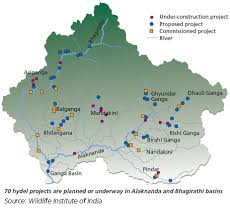
The dams in Uttarakhand include the Tehri Dam, Vishnuprayag Dam, and Srinagar Dam. The Tehri Dam is the largest dam in India and is located on the Bhagirathi River. The Vishnuprayag Dam is located on the Alaknanda River. The Srinagar Dam is located on the Mandakini River.
What are the effects of dams on the environment?
Dams can have a number of negative effects on the environment. They can block the flow of water, which can lead to the loss of wetlands and fish habitat. They can also cause changes in water temperature and salinity, which can harm aquatic life. Dams can also lead to the displacement of people who live in the area.
What are the benefits of dams?
Dams can have a number of positive effects on the environment. They can provide water for irrigation, drinking, and hydroelectric power. They can also help to control flooding and improve water quality. Dams can also provide a habitat for fish and other aquatic life.
What are the challenges of managing the drainage system of Uttarakhand?
The drainage system of Uttarakhand is facing a number of challenges. The state is experiencing rapid Population Growth, which is putting a strain on the water Resources. The state is also experiencing Climate Change, which is leading to more extreme weather events, such as floods and droughts. These challenges are making it difficult to manage the drainage system and protect the environment.
What are the solutions to the challenges of managing the drainage system of Uttarakhand?
There are a number of solutions to the challenges of managing the drainage system of Uttarakhand. The state needs to invest in Infrastructure-2/”>INFRASTRUCTURE, such as dams and reservoirs, to store water. The state also needs to improve water management practices, such as irrigation efficiency and rainwater harvesting. The state also needs to address climate change, such as by planting trees and reducing greenhouse gas emissions.
The main river in Uttarakhand is the:
(A) Ganga
(B) Yamuna
(C) Brahmaputra
(D) NarmadaThe main tributaries of the Ganga in Uttarakhand are the:
(A) Alaknanda, Mandakini, and Bhagirathi
(B) Yamuna, Chambal, and Son
(C) Brahmaputra, Teesta, and Manas
(D) Narmada, Tapti, and GodavariThe main tributaries of the Yamuna in Uttarakhand are the:
(A) Alaknanda, Mandakini, and Bhagirathi
(B) Tons, Kali, and Saryu
(C) Chambal, Banas, and Chambal
(D) Son, Betwa, and KenThe main tributaries of the Brahmaputra in Uttarakhand are the:
(A) Alaknanda, Mandakini, and Bhagirathi
(B) Tons, Kali, and Saryu
(C) Chambal, Banas, and Chambal
(D) Son, Betwa, and KenThe main tributaries of the Narmada in Uttarakhand are the:
(A) Alaknanda, Mandakini, and Bhagirathi
(B) Tons, Kali, and Saryu
(C) Chambal, Banas, and Chambal
(D) Son, Betwa, and KenThe main dams in Uttarakhand are the:
(A) Tehri Dam, Vishnugad Pipalkoti Dam, and Lakhwar Dam
(B) Sardar Sarovar Dam, Indira Sagar Dam, and Omkareshwar Dam
(C) Damodar Valley Corporation, Hirakud Dam, and Rihand Dam
(D) Nagarjuna Sagar Dam, Srisailam Dam, and Almatti DamThe main wildlife sanctuaries in Uttarakhand are the:
(A) Jim Corbett National Park, Rajaji National Park, and Nanda Devi National Park
(B) Kanha National Park, Bandhavgarh National Park, and Pench National Park
(C) Kaziranga National Park, Manas National Park, and Periyar National Park
(D) Gir National Park, Sanjay Gandhi National Park, and Tadoba Andhari Tiger ReserveThe main hill stations in Uttarakhand are the:
(A) Mussoorie, Nainital, and Almora
(B) Shimla, Manali, and Dalhousie
(C) Darjeeling, Kalimpong, and Gangtok
(D) Ooty, Kodaikanal, and MunnarThe main languages spoken in Uttarakhand are:
(A) Hindi, Garhwali, and Kumaoni
(B) Punjabi, Haryanvi, and Rajasthani
(C) Bengali, Assamese, and Oriya
(D) Kannada, Tamil, and TeluguThe main religions practiced in Uttarakhand are:
(A) Hinduism, Buddhism-2/”>Buddhism, and Jainism
(B) Islam, Christianity, and Sikhism
(C) Judaism, Zoroastrianism, and Baha’i Faith
(D) Shintoism, Confucianism, and Taoism