<<–2/”>a >a href=”https://exam.pscnotes.com/space-technology-indian-space-programs/”>Space Technology– Indian space programs.
Application of Satellites for different purposes
Despite being a developing economy with its attendant problems, India has effectively developed space technology and has applied it successfully for its rapid development and today is offering a variety of space Services globally.
Indian Space Program:
During the formative decade of 1960s, space research was conducted by India mainly with the help of sounding rockets. The Indian Space Research Organisation (ISRO) was formed in 1969. Space research activities were provided additional fillip with the formation of the Space Commission and the Department of Space by the government of India in 1972. And, ISRO was brought under the Department of Space in the same year.
In the history of the Indian space programme, 70s were the era of Experimentation during which experimental satellite programmes like Aryabhatta, Bhaskara, Rohini and Apple were conducted. The success of those programmes, led to era of operationalisation in 80s during which operational satellite programmes like INSAT and IRS came into being. Today, INSAT and IRS are the major programmes of ISRO.
For launching its spacecraft indigenously, India is having a robust launch vehicle programme, which has matured to the state of offering launch services to the outside world. Antrix, the commercial arm of the Department of Space, is Marketing India’s space services globally. Fruitful co-operation with other space faring nations, international bodies and the developing world is one of the main characteristics of India’s space programme.
The most significant milestone of the Indian Space Programme during the year 2005-2006 was the successful launch of PSLV-C6. On 5 May 2005, the ninth flight of Polar Satellite Launch Vehicle (PSLV-C6) from Satish Dhawan Space Centre (SDSC) SHAR, Sriharikota successfully placed two satellites – the 1560 kg CARTOSTAR-1 and 42 kg HAMSAT – into a predetermined polar Sun Synchronous Orbit (SSO). Coming after seven launch successes in a row, the success of PSLV-C6 further demonstrated the reliability of PSLV and its capability to place payloads weighing up to 1600 kg satellites into a 600 km high polar SSO.
The successful launch of INSAT-4A, the heaviest and most powerful satellite built by India so far; on 22 December 2005 was the other major event of the year 2005-06. INSAT-4A is capable of providing Direct-To-Home (DTH) television broadcasting services.
Besides, the setting up of the second cluster of nine Village Resource Centres (VRCs) was an important ongoing initiative of the Department of Space during the year. VRC concept integrates the capabilities of communications and earth observation satellites to provide a variety of information emanating from space systems and other IT tools to address the changing and critical needs of rural communities.
In October 2008, the first lunar mission launched by ISRO. The spacecraft, Chandrayaan took off from the Satish Dhawan Space Centre and it operated till August 2009. The project was announced by former PM Atal Bihari Vajpayee, as part of his independence day speech in 2003. The greatest achievement of this lunar project was the discovery of a large number of water Molecules in moon. ISRO plans to launch its second lunar mission, Chandrayaan 2 by 2018.
In 2014, Mangalyaan, India’s first interplanetary mission was launched, making ISRO the fourth space agency to reach Mars. Mangalyaan gained worldwide repute as being the least expensive Mars mission till date.
Recently India has launched 104 staellites at one go, which is a world record. The previous world record is with the Russian space agency with 37 satellites at one go.
India has been launching heavy satellites on its Geosynchronous Satellite Launch Vehicle (GSLV) but so far it has only been used for domestic satellites.In recent months though, there have been queries from foreign companies for launches on the GSLV.
Application of satellites for different purposes:
Satellites based on application can be categorized as follows:
Earth Observation satellite->
Starting with IRS-1A in 1988, ISRO has launched many operational remote sensing satellites. Today, India has one of the largest constellations of remote sensing satellites in operation. Currently, *thirteen* operational satellites are in Sun-synchronous orbit – RESOURCESAT-1, 2, 2A CARTOSAT-1, 2, 2A, 2B, RISAT-1 and 2, OCEANSAT-2, Megha-Tropiques, SARAL and SCATSAT-1, and *four* in Geostationary orbit- INSAT-3D, Kalpana & INSAT 3A, INSAT -3DR. Varieties of instruments have been flown onboard these satellites to provide necessary data in a diversified spatial, spectral and temporal resolutions to cater to different user requirements in the country and for global usage. The data from these satellites are used for several applications covering agriculture, water Resources, urban planning, rural development, mineral prospecting, Environment, Forestry, ocean resources and Disaster Management.
Communication satellite->
The Indian National Satellite (INSAT) system is one of the largest domestic communication satellite systems in Asia-Pacific region with nine operational communication satellites placed in Geo-stationary orbit. Established in 1983 with commissioning of INSAT-1B, it initiated a major revolution in India’s communications sector and sustained the same later. GSAT-18 joins the constellation of INSAT System consisting 14 operational satellites, namely – INSAT-3A, 3C, 4A, 4B, 4CR, 3DR and GSAT-6, 7, 8, 10, 12, 14, 15 and 16.
The INSAT system with more than 200 transponders in the C, Extended C and Ku-bands provides services to telecommunications, television broadcasting, satellite newsgathering, societal applications, weather forecasting, disaster warning and Search and Rescue operations.
Navigation satellite->
Satellite Navigation service is an emerging satellite based system with commercial and strategic applications. ISRO is committed to provide the satellite based Navigation services to meet the emerging demands of the Civil Aviation requirements and to meet the user requirements of the positioning, navigation and timing based on the independent satellite navigation system. To meet the Civil Aviation requirements, ISRO is working jointly with Airport Authority of India (AAI) in establishing the GPS Aided Geo Augmented Navigation (GAGAN) system. To meet the user requirements of the positioning, navigation and timing services based on the indigenous system, ISRO is establishing a regional satellite navigation system called Indian Regional Navigation Satellite System (IRNSS).
(a) GPS Aided GEO Augmented Navigation (GAGAN):
This is a Satellite Based Augmentation System (SBAS) implemented jointly with Airport Authority of India (AAI). The main objectives of GAGAN are to provide Satellite-based Navigation services with accuracy and Integrity required for civil aviation applications and to provide better Air Traffic Management over Indian Airspace. The system will be interoperable with other international SBAS systems and provide seamless navigation across regional boundaries. The GAGAN Signal-In-Space (SIS) is available through GSAT-8 and GSAT-10.
(b) Indian Regional Navigation Satellite System (IRNSS) : NavIC
This is an independent Indian Satellite based positioning system for critical National applications. The main objective is to provide Reliable Position, Navigation and Timing services over India and its neighbourhood, to provide fairly good accuracy to the user. The IRNSS will provide basically two types of services
Standard Positioning Service (SPS)
Restricted Service (RS)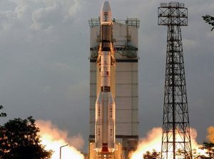
Space Segment consists of seven satellites, three satellites in GEO stationary orbit (GEO) and four satellites in Geo Synchronous Orbit (GSO) orbit with inclination of 29° to the equatorial plane. This constellation of seven satellites was named as “NavIC” (Navigation Indian Constellation) by the Honourable Prime Minister of India, Mr. Narendra Modi and dedicated to the Nation on the occasion of successful launch of IRNSS-1G, the seventh and last satellite of NavIC. All the satellites will be visible at all times in the Indian region. All the seven Satellites of NavIC, namely, IRNSS-1A, 1B, 1C, ID,1E, 1F and 1G were successfully launched on July 02, 2013, Apr 04, 2014, Oct 16, 2014, Mar 28, 2015, Jan 20, 2016, Mar 10, 2016 and Apr 28, 2016 respectively and all are functioning satisfactorily from their designated orbital positions.
Ground Segment is responsible for the maintenance and operation of the IRNSS constellation. It provides the monitoring of the constellation status, computation of the orbital and clock parameters and navigation data uploading. The Ground segment comprises of TTC & Uplinking Stations, Spacecraft Control Centre, IRNSS Timing Centre, CDMA Ranging Stations, Navigation Control Centre and Data Communication Links. Space segment is compatible with single frequency receiver for Standard Positioning Service (SPS), dual frequency receiver for both SPS & RS service and a multi mode receiver compatible with other GNSS providers.
Experimental satellite->
ISRO has launched many small satellites mainly for the experimental purposes. This experiment include Remote Sensing, Atmospheric Studies, Payload Development, Orbit Controls, recovery technology etc. Example- INS-1A, INS-1B, YOUTHSAT, APPLE
Small satellite->
The small satellite project is envisaged to provide platform for stand-alone payloads for earth imaging and science missions within a quick turn around time. For making the versatile platform for different kinds of payloads, two kinds of buses have been configured and developed.
Indian Mini Satellite -1 (IMS-1): IMS-1 bus has been developed as a versatile bus of 100 kg class which includes a payload capability of around 30 kg. The bus has been developed using various miniaturization techniques. The first mission of the IMS-1 series was launched successfully on April 28th 2008 as a co-passenger along with Cartosat 2A. Youthsat is second mission in this series and was launched successfully along with Resourcesat 2 on 20th April 2011.
Indian Mini Satellite -2 (IMS-2) Bus: IMS-2 Bus is evolved as a standard bus of 400 kg class which includes a payload capability of around 200kg. IMS-2 development is an important milestone as it is envisaged to be a work horse for different types of remote sensing applications. The first mission of IMS-2 is SARAL. SARAL is a co-operative mission between ISRO and CNES with payloads from CNES and spacecraft bus from ISRO.
Student/Academic satellite->
ISRO has influenced educational institutions by its activities like making satellites for communication, remote sensing and astronomy. The launch of Chandrayaan-1 increased the interest of universities and institutions towards making experimental student satellites.,
The Indian Space Programme (ISRO) is the space agency of India. It is headquartered in Bangalore, Karnataka. The Indian Space Programme was initiated in 1962 with the establishment of the Indian National Committee for Space Research (INCOSPAR) by the Government of India. The first Indian satellite, Aryabhata, was launched in 1975.
The objectives of the Indian Space Programme are to develop space technology for peaceful purposes, to promote self-reliance in space technology, and to use space technology for the benefit of the people of India. The Indian Space Programme has achieved many successes, including the launch of several satellites, the development of launch vehicles, and the establishment of a Network of ground stations.
The Indian Space Programme has applications in many fields, including Industry, agriculture, and rural development. In industry, space technology is used for remote sensing, navigation, and communication. In agriculture, space technology is used for weather forecasting, crop monitoring, and Irrigation planning. In rural development, space technology is used for Education, Health care, and disaster management.
The INSAT system is a series of geostationary satellites operated by the Indian Space Research Organisation (ISRO). The INSAT system provides a variety of services, including telecommunications, television broadcasting, meteorology, and disaster management. The first INSAT satellite, INSAT-1A, was launched in 1982. The INSAT system currently consists of 14 satellites in orbit.
The IRS system is a series of remote sensing satellites operated by the Indian Space Research Organisation (ISRO). The IRS system provides a variety of data, including images of the Earth’s surface, maps, and weather information. The first IRS satellite, IRS-1A, was launched in 1988. The IRS system currently consists of 10 satellites in orbit.
The future plans of the Indian Space Programme include the development of new satellites, launch vehicles, and ground stations. The Indian Space Programme also plans to expand its applications in various fields, including industry, agriculture, and rural development.
The Indian Space Programme has made significant contributions to the development of India. The Indian Space Programme has helped to improve the lives of millions of people in India. The Indian Space Programme has also helped to promote India’s image in the world.
Frequently Asked Questions about the Indian Space Programme
What is the Indian Space Programme?
The Indian Space Programme (ISRO) is the governmental agency responsible for space research and development in India. It was established in 1969 with the goal of developing indigenous space capabilities.What are the main achievements of the Indian Space Programme?
Some of the main achievements of the Indian Space Programme include:The launch of the first Indian satellite, Aryabhata, in 1975.
- The development of the Polar Satellite Launch Vehicle (PSLV), which is one of the most reliable launch vehicles in the world.
- The launch of the Chandrayaan-1 mission to the Moon in 2008.
The launch of the Mangalyaan mission to Mars in 2013.
What are the applications of the Indian Space Programme?
The Indian Space Programme has a wide range of applications, including:Telecommunications: The Indian Space Programme has developed a number of satellites that are used for telecommunications, including the INSAT series of satellites. These satellites provide communication services to millions of people in India.
- Earth observation: The Indian Space Programme has developed a number of satellites that are used for earth observation, including the IRS series of satellites. These satellites provide data on a variety of topics, such as agriculture, forestry, and Water Resources.
- Navigation: The Indian Space Programme has developed a number of satellites that are used for navigation, including the GAGAN system. This system provides accurate navigation signals to users in India.
Meteorology: The Indian Space Programme has developed a number of satellites that are used for meteorology, including the INSAT series of satellites. These satellites provide data on weather patterns, which is used to forecast the weather.
What are the future plans of the Indian Space Programme?
The Indian Space Programme has ambitious plans for the future, including:The development of a reusable launch vehicle.
- The launch of a human spaceflight mission.
- The establishment of a space station.
Frequently Asked Questions about INSAT and IRS systems
What is INSAT?
INSAT is a series of geostationary satellites that are used for telecommunications, meteorology, and Disaster Management in India. The first INSAT satellite was launched in 1983, and there are currently 14 INSAT satellites in orbit.What is IRS?
IRS is a series of remote sensing satellites that are used for earth observation in India. The first IRS satellite was launched in 1988, and there are currently 10 IRS satellites in orbit.What are the applications of INSAT and IRS systems?
INSAT and IRS systems have a wide range of applications, including:Telecommunications: INSAT satellites are used to provide telecommunications services to millions of people in India. These services include telephone, television, and Internet.
- Meteorology: IRS satellites are used to provide meteorological data, which is used to forecast the weather. This data is also used to monitor Climate change.
- Disaster management: INSAT and IRS satellites are used to monitor natural disasters, such as floods, Earthquakes, and Cyclones-2/”>Cyclones. This data is used to help with disaster relief efforts.
- Agriculture: IRS satellites are used to monitor crops and Soil conditions. This data is used to help farmers with crop planning and irrigation.
- Forestry: IRS satellites are used to monitor forests and forest cover. This data is used to help with forest management and conservation.
- Water resources: IRS satellites are used to monitor water resources, such as rivers, lakes, and Dams. This data is used to help with water management and planning.
- Urban planning: IRS satellites are used to monitor urban areas. This data is used to help with urban planning and development.
Coastal management: IRS satellites are used to monitor coastal areas. This data is used to help with coastal management and planning.
What are the future plans for INSAT and IRS systems?
The Indian Space Research Organisation (ISRO) has ambitious plans for the future of INSAT and IRS systems. These plans include:The development of new INSAT satellites with enhanced capabilities.
- The launch of new IRS satellites with enhanced capabilities.
- The establishment of a space-based data processing and dissemination system.
- The development of new applications for INSAT and IRS data.
Which of the following is not a satellite launched by India?
(A) INSAT
(B) IRS
(C) GSAT
(D) PSLVThe first Indian satellite was launched in the year:
(A) 1975
(B) 1980
(C) 1985
(D) 1990The Indian Space Research Organisation (ISRO) was founded in the year:
(A) 1969
(B) 1972
(C) 1975
(D) 1980The headquarters of ISRO is located in:
(A) Bangalore
(B) Hyderabad
(C) Chennai
(D) New DelhiThe first Indian astronaut to go to space was:
(A) Rakesh Sharma
(B) Sunita Williams
(C) Kalpana Chawla
(D) Abhilasha TripathiThe Indian Space Programme has been successful in launching a number of satellites into space. These satellites are used for a variety of purposes, including:
(A) telecommunications
(B) meteorology
(C) remote sensing
(D) all of the aboveThe INSAT system is a series of satellites that are used for telecommunications and meteorology. The first INSAT satellite was launched in the year:
(A) 1975
(B) 1980
(C) 1985
(D) 1990The IRS system is a series of satellites that are used for remote sensing. The first IRS satellite was launched in the year:
(A) 1988
(B) 1991
(C) 1993
(D) 1995The Indian Space Programme has made a significant contribution to the development of India. The programme has helped to improve the lives of millions of Indians by providing them with access to telecommunications, weather forecasting, and other essential services.
The Indian Space Programme is a shining example of India’s technological prowess. The programme has helped to put India on the map as a major player in the global space race.