Rivers of Goa
Drainage systems, also known as river systems, are the patterns formed by the streams, rivers, and lakes in a particular drainage basin. They are governed by the topography of the land, whether a particular region is dominated by hard or soft rocks, and the gradient of the land.
About Rivers of Goa and Drainage
- Goa, twenty fifth state of the Indian Union, is small but picturesque state, famous all over the world as “The Tropical Paradise of Tourists”.
- Ensconced on the slopes of Western Ghats which skirts its eastern boundary and lapped by the blue expanse of the Arabian Sea in the West, Goa admeasures an area of about 3,702 sqkm.
- Goa Situated between Karnataka and Maharashtra.
- Goa is bounded on the North by the Terekhol River, surrounded on the South and East by Karnataka while on the West is the Arabian sea.
- This state is divided into two districts, North and South, administered from Panaji, the capital city and Margao, respectively
- There are nine major rivers in Goa flowing from East (Western Ghat) to West (Arabian Sea) except Sal River.
- Terekhol, Chapora, Baga, Mandovi, Zuari, Sal, Saleri, Talpona, Galgibag are the main nine rivers of Goa. Among these rivers Mandovi and Zuari drain 2553 Sq. Km, about 70% of the total geographical area of Goa.
- Out of nine rivers, six originate and flow exclusively within the state boundaries and do not have any interstate implications.
- However, river Terekhol and Chapora originate in Maharashtra state while Mandovi originates in Karnataka.
- These rivers form an integral part of Goan life because of their portability, Irrigation facilities, agriculture and coastal Resources, transportation of mining ores, etc
- Rivers of Goa are unique and are both tidal as well as Rainfed. In Goa, during monsoon, water within the watershed areas is drained out through the major rivers to the sea.
- The rivers are influenced by the tidal influx upto the distance of 40Km inland towards upstream.
- Salinity factor in the river varies sharply during monsoon and non-monsoon seasons and so does the physico-chemical quality of water in wells along the riverbanks.
| River Basin in Goa | Length within the state | Basin Area in Sq. Kms. |
| Terekhol | 26 | 71 |
| Chapora | 32 | 255 |
| Baga | 10 | 50 |
| Mandovi | 52 | 1580 |
| Zuari | 145 | 973 |
| Sal | 40 | 301 |
| Saleri | 11 | 149 |
| Talpona | 32 | 233 |
| Galgibag | 14 | 90 |
| Total | 3702 Sq. Kms. |
Madovi and Zuari: Two most important Rivers of Goa
- Goa’s Riverine landscape is dominated by Mandovi and Zuari rivers.
- According to the recent findings of National Institute for Oceanography during the last glacial period, i.e. 20,000 years ago, both rivers, Mandovi and Zuari, flowed through the rocky terrain as a single river system before branching out separately.
Mandovi River
- The Mandovi also called Mahadayi rises at an elevation of 600 m in the main Sahyadris above the Kelil Ghat in a Degao village of Belgaum district of Karnataka state, located on the western fringe of the Karnataka Plateau.

- Flowing for 29 km through Uttar Kannada District of Karnataka State the river enters Goa State via Sattari Taluka of North Goa District.
- River is flowing a length of 52 km within the Goa State it falls into Arabian Sea at the Marmagao Bay near Panjim.
- Catchment of Mandovi River lies in Goa and partly in Karnataka making it an interstate river. Within Goa State the Mandovi River drains an area of 1,580 sq km covering about 42% area of the state.
- In the upper reaches of the Sattari valley, this river is called the Mhadei (meaning Great Mother). After its confluence with the Khandepar river at Bembol (Bicholim) it is called Mandovi till it meets the Arabian Sea ahead of Panaji.
- Mhadei River is an important tributary of Mandovi holds a great ecological significance for the state. About 85% of the area of Mhadei watershed is forest and is home for Mhadei Wildlife Sanctuary.
- Mandovi River has the largest basin in Goa.
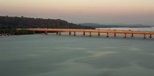
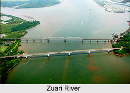
Zuari River
- Zuari River is the longest river in the state and has second largest basin.
- Zuari is believed to have been known in the earlier times as the Aghanashini, the destroyer of sin.
- Zuari’s source water; lies entirely within the state, with the inter-state boundary almost following the water divide.
- Referred to as a tidal river, Zuari originates in the Dighi Ghat of the Karnataka part of the Sahyadri Hills and after flowing a zigzag stretch of about 145 km joins the Arabian Sea at Mormugao – Dona Paula point.

- Zuari basin extending from Netravali to Panjim covers an area of about 975 km2 and constitutes about 27 % of the total area of Goa.
- The basin has forest area of 31.4% and hosts Netravali Wildlife Sanctuary.
Waters of Mandovi and Zuari are extensively used for drinking and agriculture purposes. Mandovi also serves as an important internal navigation route for commercial purpose. Panaji, the state capital and Old Goa, the former capital of Goa, are both situated on the left bank of the Mandovi.
Terekhol River
- The Terekhol River is a river in western India. In its upper reaches it is known as the Banda River and in the lower reaches as the Terekhol.
- It forms the boundary between Sindhudurg district of Maharashtra state and North Goa district of Goa state for some distance.
- The Terekhol rises in the environs of the Manohargad in the Western Ghats and flows in a south-westerly direction to meet the Arabian Sea.
- Terekhol fort is located on the northern bank of this river in the far north of Goa.
- From Kerim one can cross the Terekhol River by ferry and then it is 2 km to the fort.
Chapora River
- Chapora River is a river in northern Goa, India.
- It runs westward into the Arabian sea at Chapora and demarcates the border between the North Goa talukas of Pernem and Bardez.

- The river originates at Ramghat in the neighbouring state of Maharashtra enters Goa and flows into the Arabian Sea.
- Vagator Beach, a tourist destination, is located at the estuary to the south, and to the north is the village of Morjim.
- There is a bridge across Chapora from Morjim to Siolim.
- In the 18th century, the river marked the boundary between Portuguese Goa and India
Sal River
- The Sal River is a small river in Salcete, Goa, India.
- The river opens near Margao and passes through the villages of Benaulim, Navelim, Varca, Orlim, Carmona, Dramapur, Chinchinim, Assolna, Cavelossim, Mobor and drains itself into the Arabian Sea at Betul.
- Local residents of Benaulim have been complaining to the Government since 2008 about pollution and the dumping of garbage into the river and residents of Carmona have raised a Greenpeace petition to stop a “mega-housing project” which it is feared will add to the pollution.
Mapusa River
- Mapusa River is a tributary of the River Mandovi in Goa, India.
- The river originates from the jungles of Dumacem and Amthane, meanders eastward and then southward before it drains itself in the Mandovi River at place of Penha de France.
- Mapusa River has separated Corjuem from mainland Aldona.
- The river has since ancient times been used a popular waterway to transport agricultural products and spices.
- The town of Mapusa is the largest town located on the banks of the Rivers of Goa.
,
Goa is a state in western India with coastlines stretching along the Arabian Sea. Its major cities are Panaji, Margao, and Vasco Da Gama. It is known for its beaches, ranging from popular stretches at Baga and Palolem to those in laid-back fishing villages such as Agonda. Inland, Goa is hilly and forested, and its wildlife sanctuaries shelter elephants, langur monkeys, and tigers.
Goa is also home to a number of rivers, which play an important role in the state’s economy and ECOLOGY. The Mandovi River is the longest river in Goa, flowing from the Western Ghats Mountains to the Arabian Sea. The Zuari River is the second-longest river in Goa, and it is also an important source of water for irrigation and drinking. The Terekhol River is a tributary of the Mandovi River, and it is known for its beautiful waterfalls. The Chapora River is a tributary of the Zuari River, and it is a popular spot for swimming and fishing. The Sal River is a tributary of the Terekhol River, and it is an important source of water for irrigation and drinking. The Cumbarjua Canal is a man-made canal that connects the Mandovi River to the Zuari River. It is an important source of water for irrigation and drinking. The Anjunem River is a small river that flows through the Anjuna village. It is a popular spot for swimming and fishing. The Galgibag River is a small river that flows through the Galgibag village. It is a popular spot for swimming and fishing. The Baga River is a small river that flows through the Baga village. It is a popular spot for swimming and fishing. The Assonora River is a small river that flows through the Assonora village. It is a popular spot for swimming and fishing. The Tiracol River is a small river that flows through the Tiracol village. It is a popular spot for swimming and fishing. The Talpona River is a small river that flows through the Talpona village. It is a popular spot for swimming and fishing.
The rivers of Goa are an important part of the state’s economy and ecology. They provide water for irrigation, drinking, and Industry. They also support a variety of wildlife, including fish, birds, and mammals. The rivers are also a popular destination for tourists, who enjoy swimming, fishing, and boating.
The rivers of Goa are facing a number of challenges, including pollution, deforestation, and Climate change. Pollution from industries and sewage is a major problem, and it is having a negative impact on the Health of the rivers and the wildlife that depends on them. Deforestation is also a problem, as it is leading to Soil erosion and the loss of habitat for wildlife. Climate Change is also having an impact on the rivers, as it is leading to changes in rainfall patterns and sea levels. These changes are making it more difficult for the rivers to support the wildlife that depends on them.
Despite the challenges they face, the rivers of Goa are still an important part of the state’s economy and ecology. They provide water for irrigation, drinking, and industry. They also support a variety of wildlife, including fish, birds, and mammals. The rivers are also a popular destination for tourists, who enjoy swimming, fishing, and boating. It is important to protect the rivers of Goa so that they can continue to provide these benefits to the state.
Here are some frequently asked questions and short answers about rivers:
What is a river?
A river is a natural watercourse, flowing towards an ocean, sea, lake or another river.What are the different types of rivers?
There are three main types of rivers: perennial, intermittent, and ephemeral. Perennial rivers flow year-round, while intermittent rivers flow only during certain times of the year. Ephemeral rivers flow only after heavy rains.What are the different parts of a river?
The different parts of a river include the source, the headwaters, the trunk stream, the tributaries, the floodplain, the delta, and the mouth. The source is the beginning of the river, the headwaters are the upper reaches of the river, the trunk stream is the main channel of the river, the tributaries are smaller streams that flow into the river, the floodplain is the area of land that is flooded when the river overflows its banks, the delta is the fan-shaped deposit of sediment at the mouth of the river, and the mouth is the point where the river meets the ocean, sea, lake, or another river.What are the different features of a river?
The different features of a river include the riverbed, the riverbank, the current, the water level, the water temperature, the water quality, and the aquatic life. The riverbed is the bottom of the river, the riverbank is the edge of the river, the current is the movement of water in the river, the water level is the height of the water in the river, the water temperature is the temperature of the water in the river, the water quality is the cleanliness of the water in the river, and the aquatic life is the Plants and animals that live in the river.What are the benefits of rivers?
Rivers provide many benefits, including water for drinking, irrigation, and industry, transportation, recreation, and flood control.What are the challenges of rivers?
Rivers face many challenges, including pollution, Dams, and climate change. Pollution can come from a variety of sources, including agriculture, industry, and sewage. Dams can block the flow of water and disrupt the natural ecosystem. Climate change can cause changes in the water level, temperature, and flow of rivers.What are the conservation efforts for rivers?
There are many conservation efforts underway to protect rivers, including restoring degraded rivers, preventing pollution, and managing dams. Restoring degraded rivers involves removing dams, restoring wetlands, and planting trees. Preventing pollution involves reducing agricultural runoff, industrial pollution, and sewage pollution. Managing dams involves releasing water from dams during times of low water flow and operating dams in a way that minimizes the impact on the Environment.What is the future of rivers?
The future of rivers is uncertain. The challenges that rivers face, such as pollution, dams, and climate change, are likely to continue to impact rivers in the future. However, there are also many conservation efforts underway to protect rivers. The future of rivers will depend on the success of these conservation efforts.
Which of the following is not a river in Goa?
(A) Mandovi
(B) Zuari
(C) Sal
(D) NarmadaWhich of the following is the longest river in Goa?
(A) Mandovi
(B) Zuari
(C) Sal
(D) TerekholWhich of the following is the largest river in Goa?
(A) Mandovi
(B) Zuari
(C) Sal
(D) TerekholWhich of the following rivers flows through the capital city of Panaji?
(A) Mandovi
(B) Zuari
(C) Sal
(D) TerekholWhich of the following rivers is a tributary of the Mandovi?
(A) Chapora
(B) Baga
(C) Calangute
(D) AnjunaWhich of the following rivers is a tributary of the Zuari?
(A) Tiracol
(B) Sanvordem
(C) Curchorem
(D) MargaoWhich of the following rivers is a tributary of the Sal?
(A) Galgibag
(B) Netravali
(C) Harvalem
(D) MandremWhich of the following rivers is a tributary of the Terekhol?
(A) Talpona
(B) Galgibag
(C) Netravali
(D) HarvalemWhich of the following rivers is a perennial river?
(A) Mandovi
(B) Zuari
(C) Sal
(D) TerekholWhich of the following rivers is a seasonal river?
(A) Galgibag
(B) Netravali
(C) Harvalem
(D) Talpona