Rivers and Drainage System of Odisha
Following is the list of important rivers of Odisha:
Mahanadi
Brahmani
Baitarani
Subarnarekha
Budhabalanga
Rushikulya
Bahuda
vamsadhara
Nagavali
Salandi
Indirabati Kolab
Baitarani River
The Baitarani is one of the important east flowing rivers of peninsular India, flowing eastward and joining the Bay of Bengal. The river rises in the hill ranges of Keonjhar District of Orissa near Manakarancho village at an elevation of about 900m above M.S.L. On its way, many tributaries join the river from both banks. Details of the tributaries have been given in the table below. The basin is situated approximately between east longitudes of 850 – 10’to 870-03’and between north latitudes of 200-35’to 220-15’. The basin is surrounded by the Brahmani on the south and west, the Subernarekha on the orth, the Burhganbalang and the Bay of Bengal on the east. The river is flashy in nature having a total length of 355 km. With the upper reach upto to Anandpur in the hilly reason. There is a considerable fall in geographical gradient from RL 367.000 m at Champua to RL 28.000 m at Anandpur.
Brahmani
The Brahmani is a major inter-state east flowing river amongst the peninsular rivers in India. This basin is situated within the geographical co-ordinates of north latitude 20°-28′- to 23°-35′ and east longitude 83°52′ to 87°03′ approximately. The basin is bounded in the North by Chhotanagpur plateau, in the West and South by the Mahanadi basin and in the East by the Bay of Bengal. The basin flows through Jharkhand, Chhattisgarh and Orissa States and draining a total area of 39,033 sq.km. before it outfalls in to the Bay of Bengal.
Indravati
The river Indravati rises at an elevation of 914 metres in the Kalahandi district of Odisha on the western slopes of the Eastern Ghats. It flows west-ward through the Kalahandi, Nabarangapur and Koraput districts for 164 kms and after forming the boundary between Odisha and Chhattisgarh states for 9.5 kms, enters the Bastar district of Chhattisgarh. After flowing 233 kms in Chhattisgarh, it turns south and flows along the boundary of Chhattisgarh and Maharashtra for about 129 kms and joins Godavari River at the junction of the boundaries of Maharashtra, Chhattisgarh and Telangana states.
Mahanadi
The Mahanadi basin extends over states of Chhattisgarh and Odisha and comparatively smaller portions of Jharkhand, Maharashtra and Madhya Pradesh, draining an area of 1,41,589 Sq.km which is nearly 4.3% of the total geographical area of the country. The geographical extent of the basin lies between 80°28’ and 86°43’ east longitudes and 19°8’ and 23°32’ north latitudes. The basin has maximum length and width of 587 km and 400 km. It is bounded by the Central India hills on the north, by the Eastern Ghats on the south and east and by the Maikala range on the west. The Mahanadi is one of the major rivers of the country and among the peninsular rivers, in water potential and flood producing capacity, it ranks second to the Godavari. It originates from a pool, 6 km from Farsiya village of Dhamtari district of Chhattisgarh. The total length of the river from origin to its outfall into the Bay of Bengal is 851 km. The Seonath, the Hasdeo, the Mand and the Ib joins Mahanadi from left whereas the Ong, the Tel and the Jonk joins it from right. Six other small streams between the Mahanadi and the Rushikulya draining directly into the Chilka Lake also forms the part of the basin. The major part of basin is covered with agricultural land accounting to 54.27% of the total area and 4.45% of the basin is covered by water bodies.
Subarnarekha
After originating near piska/nagri, near Ranchi, the capital of Jharkhand, the Subarnarekha traverses a long distance through Ranchi Seraikela Kharsawan and East Singhbhum districts in the state. Thereafter, it flows for shorter distances through Paschim Medinipur district in West Bengal for 83 kilometres (52 mi) and Balasore district of Odisha. There, it flows for 79 kilometres (49 mi) and joins the Bay of Bengal near Talsari. The total length of the river is 395 kilometres (245 mi). The basin of the Subarnarekha is smaller than most multi-state river basins in India. The rain-fed river covers a drainage area of 18,951 square kilometres (7,317 sq mi) Fishing at Subarnarekha river near Domohani (confluence of Subarnarekha and Kharkhai) The prominent tributaries of the Subarnarekha are Kharkai, Roro, Kanchi, Harmu Nadi, Damra, Karru, Chinguru, Karakari, Gurma, Garra, Singaduba, Kodia, Dulunga and Khaijori. The Kharkai meets the Subarnarekha at Sonari (Domuhani), a neighborhood of Jamshedpur.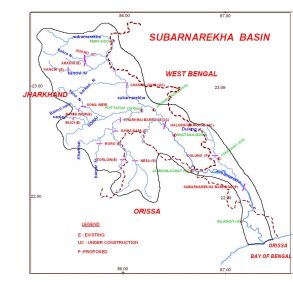
Nagavali
Nagavali River forms a prime river of north eastern Andhra Pradesh and southern Odisha. The origin of Nagavali River lies in the eastern slopes of the Eastern Ghats near Lakhbahal, located at an altitude of 1,300 metres in the Kalahandi district of the Indian state Odisha. Langulya is another name for Nagavali River. Nagavali river basin hosts the Niyamgiri hills where the Bauxite mining has been made proposed. However it has been predicted that from the red mud dump area of the Bauxite refinery the rain water run off can pollute the Nagavali River by enhancing the alkalinity of its water.
Nagavali River has a number of tributaries namely Vegavati, Relligedda, Vonigedda, Suvarnamukhi, Vottigedda, Gumudugedda, Srikona, Sitagurha, Satnala, Baldiya, Barha and Jhanjavati. Suvarnamukhi River has its origin in the hills of Salur mandal from where it flows towards an eastern direction, finally joining the Nagavali at Sangam village situated in the Vangara mandal of Srikakulam district. However the origin of Vegavathi River lies in Pachipenta Hills of Pachipenta Mandal.
vamsadhara river
Vamsadhara River is a significant east flowing river between Godavari and Mahanadi which meanders between north-eastern Andhra Pradesh and southern Odisha. It is also known as Bansadhara in the state of Odisha. The origin of the river lies in the border of Kalyansinghpur in Rayagada district and Thuamul Rampur in Kalahandi district of Odisha. The river flows for a length of 254 kilometres after which it joins the Bay of Bengal at Kalingapatnam in Andhra Pradesh. The catchment area of the river comprises an area of 10,830 square kilometres. Kalingapatnam and Mukhalingam, the famed tourist attractions of Srikakulam district are situated along the banks of Vamsadhara River.
One of the major tributaries of Vamsadhara River is Mahendratanaya which originates in Gajapati district of Odisha. It joins the main river in the state of Andhra Pradesh, upstream of Gotta barrage. For diverting the river for Irrigation purpose, the construction of Regulapadu barrage has been started.
Bahuda river
The river Bahuda originates near village Luba from the Singharaj hills of the Eastern Ghats in Gajapati district. It flows in the north east direction up to 55 km, south east direction for 17km in Odisha before entering Andhra Pradesh to flow for 18 km. Then it turns in Northeast direction for 6 km in Odisha before meeting the Bay of Bengal near the village Sunapurapeta, Odisha. The river traverses a total length of 96 km and the prominent tributaries are Poichandia, Bogiriadi, Batrada Nalla and Kantajura Nalla. The river is effectively providing water to more than 23,000 acres of the land which includes more than 90 villages in that area.
Rushikulya
The Rushikulya originates at an elevation of about 1000 m. from Rushimala Hills near Matabarhi village of Kandhamal district which is lies within the geographical coordinates of 19.07 to 20.19 north latitude and 84.01 to 85.06 east longitude. It meets the Bay of Bengal at Puruna Bandha of Chhatrapur block.
Its tributaries are the Baghua, the Dhanei, the Badanadi etc. It has no delta as such at its mouth.
It is 165 km long with the total catchment area is 7700 km2. It covers entire catchment area in the districts of Kandhamal and Ganjam district of Odisha.
,
Odisha is a state in eastern India. It is bordered by the states of West Bengal to the north, Jharkhand to the northwest, Chhattisgarh to the west, Andhra Pradesh to the south, and the Bay of Bengal to the east. The state has a Population of over 45 million people and a land area of over 155,000 square kilometers.
The capital of Odisha is Bhubaneswar. The other major cities in the state are Cuttack, Rourkela, Sambalpur, and Berhampur.
Odisha is a land of diverse geography. The state has a long coastline, with a number of beaches and islands. The eastern part of the state is covered by the Eastern Ghats, while the western part is covered by the Deccan Plateau. The state is also home to a number of rivers, including the Mahanadi, Brahmani, Baitarani, Indravati, Subarnarekha, Budhabalanga, Tel, and Brahmani-Mahanadi.
The Climate-of-odisha/”>Climate of Odisha is tropical. The state experiences two main seasons: the monsoon season (June-September) and the winter season (December-February). The monsoon season is characterized by heavy rainfall, while the winter season is characterized by cool weather.
Odisha is a rich and diverse state with a long history and culture. The state is home to a number of ethnic groups, including the Odia, the Santali, the Munda, and the Kui. The state is also home to a number of religions, including Hinduism-2/”>Hinduism, Buddhism-2/”>Buddhism, and Christianity.
Odisha is a developing state with a growing economy. The state is home to a number of industries, including steel, mining, and power generation. The state is also home to a number of agricultural products, including rice, wheat, and sugarcane.
Odisha is a beautiful and scenic state with a lot to offer visitors. The state is home to a number of historical and cultural sites, including the temples of Bhubaneswar, the Sun Temple of Konark, and the Jagannath Temple of Puri. The state is also home to a number of natural attractions, including the beaches of Puri, the hills of the Eastern Ghats, and the forests of the Western Ghats.
The rivers and drainage system of Odisha are an important part of the state’s economy and Environment. The rivers provide water for irrigation, drinking, and industrial use. The rivers also support a variety of fish and other aquatic life. The drainage system of Odisha is also important for the state’s tourism Industry. The rivers and waterfalls of Odisha are popular tourist destinations.
However, human activities have had a significant impact on the rivers and drainage system of Odisha. Deforestation, mining, and industrial pollution have all contributed to the degradation of the state’s rivers. As a result, the rivers of Odisha are now more prone to flooding and erosion. The water quality of the rivers has also declined, making it unsafe for drinking and irrigation.
The government of Odisha is taking steps to address the problem of river pollution. However, more needs to be done to protect the rivers and drainage system of Odisha.
What are the major rivers of Odisha?
The major rivers of Odisha are Mahanadi, Brahmani, Baitarani, Indravati, Subarnarekha, and Rushikulya.
What is the drainage system of Odisha?
The drainage system of Odisha is a complex Network of rivers, streams, and tributaries. The major rivers of Odisha are Mahanadi, Brahmani, Baitarani, Indravati, Subarnarekha, and Rushikulya. These rivers flow through the state and drain into the Bay of Bengal.
What is the importance of rivers in Odisha?
Rivers are important for the economy, environment, and culture of Odisha. They provide water for irrigation, drinking, and industrial use. They also support a variety of Ecosystems and are a source of livelihood for many people.
What are the challenges facing the rivers of Odisha?
The rivers of Odisha are facing a number of challenges, including pollution, deforestation, and Climate Change. Pollution from industrial and agricultural activities is a major problem. Deforestation is leading to Soil erosion and siltation of rivers. Climate change is causing changes in the flow of rivers and is leading to more extreme weather events, such as floods and droughts.
What are some of the initiatives that are being taken to protect the rivers of Odisha?
The government of Odisha is taking a number of initiatives to protect the rivers of the state. These include:
- Pollution control: The government is implementing a number of measures to control pollution from industrial and agricultural activities. These include setting up pollution control units, monitoring the quality of water, and enforcing environmental laws.
- Reforestation: The government is planting trees to prevent soil erosion and siltation of rivers. It is also promoting afforestation in degraded areas.
- Climate change adaptation: The government is taking a number of measures to adapt to climate change. These include building flood control structures, improving Drainage Systems, and raising awareness about climate change.
What are the benefits of protecting the rivers of Odisha?
Protecting the rivers of Odisha will have a number of benefits, including:
- Improved water quality: Protecting the rivers will help to improve the quality of water for drinking, irrigation, and industrial use.
- Reduced flooding: Protecting the rivers will help to reduce the risk of flooding.
- Improved Biodiversity-2/”>Biodiversity: Protecting the rivers will help to improve the biodiversity of the state.
- Increased tourism: Protecting the rivers will help to increase tourism in the state.
What can individuals do to help protect the rivers of Odisha?
Individuals can help to protect the rivers of Odisha by:
- Reducing pollution: Individuals can reduce pollution by using less water, recycling, and disposing of waste properly.
- Conserving water: Individuals can conserve water by taking shorter showers, fixing leaky faucets, and planting drought-tolerant Plants.
- Recycling: Individuals can recycle paper, plastic, Metal, and glass.
- Using less energy: Individuals can use less energy by turning off lights when they leave a room, unplugging appliances when they are not in use, and using energy-efficient appliances.
- Planting trees: Individuals can plant trees to help prevent soil erosion and siltation of rivers.
- Supporting environmental organizations: Individuals can support environmental organizations that are working to protect the rivers of Odisha.
Which of the following is not a river in Odisha?
(A) Mahanadi
(B) Brahmani
(C) Godavari
(D) KaveriThe Mahanadi river originates in which of the following states?
(A) Odisha
(B) Chhattisgarh
(C) Andhra Pradesh
(D) JharkhandThe Brahmani river originates in which of the following states?
(A) Odisha
(B) Jharkhand
(C) Chhattisgarh
(D) Andhra PradeshThe Godavari river originates in which of the following states?
(A) Odisha
(B) Chhattisgarh
(C) Andhra Pradesh
(D) TelanganaThe Kaveri river originates in which of the following states?
(A) Odisha
(B) Andhra Pradesh
(C) Karnataka
(D) Tamil NaduThe Mahanadi river is the longest river in which of the following states?
(A) Odisha
(B) Chhattisgarh
(C) Andhra Pradesh
(D) JharkhandThe Brahmani river is the longest river in which of the following states?
(A) Odisha
(B) Chhattisgarh
(C) Andhra Pradesh
(D) JharkhandThe Godavari river is the longest river in which of the following states?
(A) Odisha
(B) Andhra Pradesh
(C) Karnataka
(D) Tamil NaduThe Kaveri river is the longest river in which of the following states?
(A) Odisha
(B) Andhra Pradesh
(C) Karnataka
(D) Tamil NaduThe Mahanadi river is a tributary of which of the following rivers?
(A) The Brahmaputra
(B) The Ganges
(C) The Indus
(D) The NarmadaThe Brahmani river is a tributary of which of the following rivers?
(A) The Mahanadi
(B) The Godavari
(C) The Kaveri
(D) The NarmadaThe Godavari river is a tributary of which of the following rivers?
(A) The Mahanadi
(B) The Brahmani
(C) The Kaveri
(D) The NarmadaThe Kaveri river is a tributary of which of the following rivers?
(A) The Mahanadi
(B) The Brahmani
(C) The Godavari
(D) The NarmadaThe Mahanadi river is a perennial river.
(A) True
(B) FalseThe Brahmani river is a perennial river.
(A) True
(B) FalseThe Godavari river is a perennial river.
(A) True
(B) FalseThe Kaveri river is a perennial river.
(A) True
(B) FalseThe Mahanadi river is a rain-fed river.
(A) True
(B) FalseThe Brahmani river is a rain-fed river.
(A) True
(B) FalseThe Godavari river is a rain-fed river.
(A) True
(B) FalseThe Kaveri river is a rain-fed river.
(A) True
(B) FalseThe Mahanadi river is a source of irrigation for the state of Odisha.
(A) True
(B) FalseThe Brahmani river is a source of irrigation for the state of Odisha.
(A) True
(B) FalseThe Godavari river is a source of irrigation for the state of Andhra Pradesh.
(A) True
(B) FalseThe Kaveri river is a source of irrigation for the state of Tamil Nadu.
(A) True
(B) FalseThe Mahanadi river is a source of hydroelectric power for the state of Odisha.
(A) True
(B) FalseThe Brahmani river is a source of hydroelectric power for the state of Odisha.
(A) True
(B) FalseThe Godavari river is a source of hydroelectric power for the state of Andhra Pradesh.
(A) True
(B) FalseThe Kaveri river is a source of hydroelectric power for the state of Tamil Nadu.
(A) True
(B) FalseThe Mahanadi river is a source of drinking water for the state of Odisha.
(A) True