Rivers and Drainage System of Chhattisgarh:-
The rivers of Chhattisgarh are of much signifance to the state from a stand point of economic, social, political and religious views. The State of Chhattisgarh is divided in to five river basins. Mahanadi Basin drains out 75,858.45 Sq km, Godavari Basin drains out 38,694.02 Sq km, Ganga Basin drains out 18,406.65 Sq km, Brahmani Basin drains out 1,394.55 Sq km and Narmada Basin drains out 743.88 Sq km of catchment area in the state.Rivers and Drainage system of Chhattisgarh has been explained here with covering all the rivers and drainage basins.
- Mahanadi Basin:-
Mahanadi Basin extends over an area of 141589 Sq km which is nearly 4.3 percent of total geographical area of the country. The basin lies in the states of Chhattisgarh (75,858.45 Sq km), Orissa (65,580 Sq km), Bihar (635 Sq km) and Maharashtra (238 Sq km). Mahanadi river rises from Raipur district of Chhattisgarh and flows for about 851 km before its outfall into the Bay of Bengal . Its main tributaries are Seonath, Jonk, Hasdeo, Mand, Ib, Ong, and Tel. Most of the tributaries of Mahanadi join in from the western and northern side. Physiographically the basin can be divided into four regions namely the Northern, Plateau, the Eastern Ghats the Coastal Plain and the Erosional Plains of Central Table Land . The first two are hilly regions. The coastal plain is the central interior region of the basin traversed by the river and its tributaries. Main Sub Basins of Mahanadi are:–
- Seonath Sub Basin:-
The Seonath River Originates near village Panabaras in the Rajnandgaon District. The Basin area of river up to confluence with the Mahanadi River is 30,860 Sq Km . The river traverses a length 380 Km. The main tributaries of Seonath river are Tandula, Kharun, Arpa, Hamp, Agar and Maniyari Rivers. Tandula is not only an important tributary, but also forms a big reservoir in the district, from which a canal carries water towards the northeast of Durg. Kharum and Jamunia are two other important tributaries near Raipur. The mean annual rainfall in the basin varies from 1005 mm to 1255 mm.
- Hasdeo Sub basin:-
Hasdeo River, a major tributary of the mahanadi, is one of the important rivers of Chhatisgarh. Hasdeo has a total length of 245 Km and has its origin in Mendra village. It flows towards south of the state, through Koriya, Bilaspur and Korba Districts. During its course, this river merges with its tributaries such as Gej and the Chornai on the left bank and the Tan and the Ahiran on the right before it meets the mahanadi. Other tributaries of Hasdeo include Jhumka and Bania.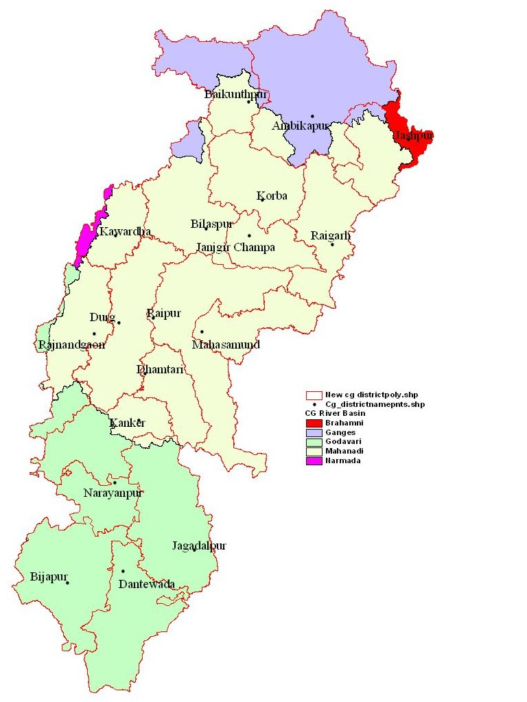
- Pairi Sub basin:-
River Pairi, running down from Raipur uplands, drains a significant portion of the entire undivided Raipur district. Originating in the Bhatigarh hills (493 m) located near Bindravagarh of Raipur District, the river flows southwards and meets the mahanadi near Rajim.
- Tel Sub basin:–
This is an important tributary of Mahanadi, which meets the main river at Sonpur or Subarnapur. Baidyanath temple, which is famous for the Kosaleshwar Shiva Temple, is located on the left bank of the tel river.
- Ib Sub basin:-
Ib river joins Mahanadi river flowing directly into the Hirakund Reservoir. The river originates in hills near Pandrapet.
- Mand Sub basin:-
Mand river joins the Mahanadi in Chandrapur, in Maharashtra, before the river reaches the Hirakund Dam.
- Jonk Sub basin:-
It flows via the Mountanious areas of the Mahasamund, the river goes eastwards to join the Mahanadi form Shivrinarayan.
- Kelo Sub basin:-
Kelo river originates in the Ludega hills located in the Raigarh District. It reaches a place name MahadevPali in Orrisa and joins the Mahanadi.
- Others Sub basin:–
Though the contribution of the tributaries from the eastern side of the
Mahanadi is lesser, both in number and in volume, three important rivers deserve a mention here. A small river, Silari, is important as it links a big reservoir, Maramsilli, in the southwest of
Raipur district to Mahanadi.
- GODAVARI BASIN:-
Godavari rises in the Sahyadris near Triambakeswar, about 80 km from the shore of Arabian Sea, at an elevation of 1,067 m in the Nasik district of Maharashtra. After flowing for about 1,465 km in a general south-easterly direction through Maharashtra and Andhra Pradesh, Godavari falls into the Bay of Bengal north of Rajahmundry. The basin extends over an area of 312,813 Sq km, which is nearly 10% of the total geographical area of the country. Out of the total basin area of 312,813 Sq km, the major parts of the basin falls in Maharashtra state. Further, about 38694.02 Sq km which is only 12.36% of the basin area falls in the Chhattisgarh state.
- Indravati Sub basin:-
Indravati is a important tributary of Godavari. The river and its tributaries are located in the Bastar area. Originating from Orissa it divides the area into two halves. Its major tributaries are Narangi, Baordhig, Nibra, Kotri, and a stream, the Chintavagu.
- Other Sub basin of Godavari Basin:-
Besides the Indravati and its tributaries, there are three important streams in the Bastar area, all direct tributaries of Godavari. These are Talperu, Chinta, and Sabari. In the Dandakaranya region lying to the south of Indravati most of the rivers are perennial, though with highly fluctuating regime. Due to rapid run-off and Evaporation, the land dries up very quickly after the monsoons. A very negligible amount of their water is used for agriculture.
- GANGA BASIN:-
The Ganga basin extends over an area of 1,086,000 Sq km. The drainage area lying in India is 862,769 Sq km which is nearly26.2% of the total geographical area of the country. Out of the total basin area about 18,406.65 Sq km which is only 1.695 % of the basin area falls in the Chhattisgarh state.
- Son sub basin:-
The river Son is an right bank tributary of the river Ganga. it originates from Amarkantak plateaeu of Maikala range in Bilaspur district of Chhatisgarh. Kanhar, Rihand, Gopad, Banas, Bijal are its other tributaries.
- Rihand river:– Rihand is a major river-body in the state, rising in the south of Surguja and flowing northwards, draining the Surguja Basin. it is a tributary of Son, which in turn merges with the Ganga. Before meeting Son, it is joined by three main tributaries during its course northwards in Surguja district. These are Gungata, Mahan and Moran.
- Kanhar river:–In the eastern part of Surguja is the Kanhar river, which flows for only for a few kilometers in this district, before joining the Son river in the state of Uttar Pradesh.
- BRAHMANI BASIN:-
The Brahmani Basin lies in the districts of Raigarh and Sarguja in Chhattisgarh, Ranchi and Singhbhumi in Jharkhand and Sundergarh, Deogarh, Sambalpur, Angul, Dhenkanal, Keonjhar, Jajpur and Kendrapara in Orissa. Brahmani basin is situated between Mahanadi Basin (on the right) and Baitarani Basin (on the left). Chhotanagpur Plateau in the East and South bound the basin, in the north a ridge separates it from Mahanadi basin, and to the east of the basin lie the Bay of Bengal and the Baitarani basin. Out of the total basin area of 39,269 Sqkm, the major parts of the basin falls in Orissa state. Further, about 1,394.45 Sqkm which is only 3.55% of the basin area falls in the Chhattisgarh state.
- NARMADA BASIN:-
The Narmada River, rises in the Amarkantak Plateau of Maikal range in the Shahdol district of Madhya Pradesh at an elevation of 1057 meters. The river travels a distance of 1,312 km before it falls into Gulf of Cambay (Khambat) in the Arabian Sea near Bharuch in Gujarat. The Narmada basin extends over an area of 98,796 Sq km and Out of the total basin area about 743.88 Sq km which is only 0.75% of the basin are falls in the Chhattisgarh state.
Thus, we find that there are many Rivers and Drainage system of Chhattisgarh and sub-basins in the region, especially in the southern and eastern parts of the state. The rivers draining these basins usually carry huge volumes in the rains, but are usually flowing in deep gorges in hilly areas. These offer a rich potential for rainwater harvesting and surface Irrigation projects that protect kharif.
,
Chhattisgarh is a state in central India. It is bordered by the states of Odisha to the east, Jharkhand to the west, Madhya Pradesh to the north, and Andhra Pradesh to the south. The state has a Population of over 29 million people and a land area of over 135,000 square kilometers.
The capital of Chhattisgarh is Raipur. The state is divided into 27 districts. The major cities of Chhattisgarh are Raipur, Bilaspur, Durg, Rajnandgaon, and Bastar.
Chhattisgarh is a land of forests and rivers. The state has a tropical Climate. The Average temperature in Chhattisgarh ranges from 15 degrees Celsius to 40 degrees Celsius. The state receives an average rainfall of 1,000 to 2,000 millimeters per year.
The major rivers of Chhattisgarh are the Mahanadi, Indravati, Hasdeo, Seonath, Son, Wainganga, Kelo, Mand, Pairi, Jonk, Shivnath, Ajay, Kharun, Balram, Durg, Arpa, and Barna. The Mahanadi is the longest river in Chhattisgarh. It is a tributary of the Godavari River. The Indravati is the second longest river in Chhattisgarh. It is a tributary of the Mahanadi River. The Hasdeo is the third longest river in Chhattisgarh. It is a tributary of the Son River. The Seonath is the fourth longest river in Chhattisgarh. It is a tributary of the Son River. The Son is the fifth longest river in Chhattisgarh. It is a tributary of the Ganges River. The Wainganga is the sixth longest river in Chhattisgarh. It is a tributary of the Godavari River. The Kelo is the seventh longest river in Chhattisgarh. It is a tributary of the Mahanadi River. The Mand is the eighth longest river in Chhattisgarh. It is a tributary of the Mahanadi River. The Pairi is the ninth longest river in Chhattisgarh. It is a tributary of the Hasdeo River. The Jonk is the tenth longest river in Chhattisgarh. It is a tributary of the Hasdeo River. The Shivnath is the eleventh longest river in Chhattisgarh. It is a tributary of the Mahanadi River. The Ajay is the twelfth longest river in Chhattisgarh. It is a tributary of the Son River. The Kharun is the thirteenth longest river in Chhattisgarh. It is a tributary of the Mahanadi River. The Balram is the fourteenth longest river in Chhattisgarh. It is a tributary of the Son River. The Durg is the fifteenth longest river in Chhattisgarh. It is a tributary of the Mahanadi River. The Arpa is the sixteenth longest river in Chhattisgarh. It is a tributary of the Hasdeo River. The Barna is the seventeenth longest river in Chhattisgarh. It is a tributary of the Hasdeo River.
The major Dams in Chhattisgarh are the Hasdeo Bango Dam, Indravati Dam, Sukma Dam, Mand Dam, Pairi Dam, Jonk Dam, Shivnath Dam, Ajay Dam, Kharun Dam, Balram Dam, Durg Dam, Arpa Dam, and Barna Dam. The Hasdeo Bango Dam is the largest dam in Chhattisgarh. It is a multipurpose dam on the Hasdeo River. The Indravati Dam is the second largest dam in Chhattisgarh. It is a multipurpose dam on the Indravati River. The Sukma Dam is a hydroelectric dam on the Sukma River. The Mand Dam is a hydroelectric dam on the Mand River. The Pairi Dam is a hydroelectric dam on the Pairi River. The Jonk Dam is a hydroelectric dam on the Jonk River. The Shivnath Dam is a hydroelectric dam on the Shivnath River. The Ajay Dam is a hydroelectric dam on the Ajay River. The Kharun Dam is a hydroelectric dam on the Kharun River. The Balram Dam is a hydroelectric dam on the Balram River. The Durg Dam is a hydroelectric dam on the Durg River. The Arpa Dam is a hydroelectric dam on the Arpa River. The Barna Dam is a hydroelectric dam on the Barna River.
The rivers and dams of Chhattisgarh are important for the state’s economy and Environment. The rivers provide water for irrigation, drinking, and hydroelectric power. The dams help to control floods and regulate the flow of water. The rivers and dams are also important for the state’s wildlife.
What are the major rivers of Chhattisgarh?
The major rivers of Chhattisgarh are the Mahanadi, the Indravati, the Hasdeo, the Son, and the Wainganga.
What is the drainage system of Chhattisgarh?
The drainage system of Chhattisgarh is a complex Network of rivers, streams, and tributaries. The major rivers of Chhattisgarh are the Mahanadi, the Indravati, the Hasdeo, the Son, and the Wainganga. These rivers flow through the state in a north-south direction and drain into the Bay of Bengal.
What is the importance of the rivers of Chhattisgarh?
The rivers of Chhattisgarh are important for a number of reasons. They provide water for irrigation, drinking, and industrial use. They are also a source of hydroelectric power. The rivers are also important for transportation and recreation.
What are the challenges facing the rivers of Chhattisgarh?
The rivers of Chhattisgarh are facing a number of challenges. These include pollution, deforestation, and Climate Change. Pollution is a major problem in the rivers of Chhattisgarh. The rivers are polluted by industrial waste, sewage, and agricultural runoff. Deforestation is also a major problem. The forests that once covered the banks of the rivers have been cut down, which has led to Soil erosion and sedimentation. Climate change is also a major challenge. Climate change is causing the rivers to become more erratic and unpredictable. This is leading to flooding and droughts.
What is being done to address the challenges facing the rivers of Chhattisgarh?
A number of things are being done to address the challenges facing the rivers of Chhattisgarh. These include:
- Pollution control: The government is working to reduce pollution in the rivers. This includes building sewage treatment Plants and enforcing environmental regulations.
- Reforestation: The government is working to reforest the banks of the rivers. This will help to prevent soil erosion and sedimentation.
- Climate change adaptation: The government is working to adapt to the effects of climate change. This includes building flood control measures and drought-resistant crops.
These are just some of the things that are being done to address the challenges facing the rivers of Chhattisgarh. The government and the people of Chhattisgarh are committed to protecting their rivers and ensuring that they are healthy and sustainable for future generations.
Which of the following is not a river in Chhattisgarh?
(A) Mahanadi
(B) Indravati
(C) Narmada
(D) GodavariThe Mahanadi river originates in which of the following states?
(A) Chhattisgarh
(B) Odisha
(C) Andhra Pradesh
(D) Madhya PradeshThe Indravati river originates in which of the following states?
(A) Chhattisgarh
(B) Odisha
(C) Andhra Pradesh
(D) Madhya PradeshThe Godavari river originates in which of the following states?
(A) Chhattisgarh
(B) Odisha
(C) Andhra Pradesh
(D) MaharashtraThe Narmada river originates in which of the following states?
(A) Chhattisgarh
(B) Madhya Pradesh
(C) Gujarat
(D) MaharashtraThe Chhattisgarh state is drained by how many major rivers?
(A) 4
(B) 5
(C) 6
(D) 7The Mahanadi river is the longest river in Chhattisgarh.
(A) True
(B) FalseThe Indravati river is the largest tributary of the Mahanadi river.
(A) True
(B) FalseThe Godavari river is the second longest river in India.
(A) True
(B) FalseThe Narmada river is the third longest river in India.
(A) True
(B) False