Relief and Structure of Telangana
Introduction:
Telangana, also spelled Telengana or Telingana, constituent state of south-central India. It is bordered by the states of Maharashtra to the north, Chhattisgarh and Odisha to the northeast, Andhra Pradesh to the southeast and south, and Karnataka to the west. The area of what is now Telangana constituted the north-central and northeastern portions of Andhra Pradesh for almost six decades, but on June 2, 2014, that territory was calved off to form a separate state. The capital of both Telangana and Andhra Pradesh is Hyderabad, in west-central Telangana.
TelenganaPlateau :
Telengana Plateau, Telengana also spelled Telangana, plateau in western Andhra Pradesh state, southeastern India. Comprising the northeastern part of the Deccan plateau, the Telengana Plateau has an area of about 57,370 square miles (148,000 square km), a north-south length of about 480 miles (770 km), and an east-west width of about 320 miles (515 km). Mentioned in one of the Mauryan emperor Ashoka’s edicts, the region was successively ruled by the Satavahanas,
The plateau is drained by the Godavari River taking a southeasterly course; by the Krishna River, which divides the peneplain into two regions; and by the Penneru River flowing in a northerly direction. The plateau’s forests are moist deciduous, dry deciduous, and tropical thorn.
Features of Telangana: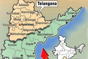
Telangana is situated on the Deccan Platue in the Indian Peninsula. The region is drained by two major rivers Godavari and River Krishna, but most of the land is arid. Telangana is also drained by several minor rivers such as the bhima, the maner, the manjira and the musi.
The annual rainfall is between 900 and 1500 mm in northern Telangana and 700 to 900 mm in southern Telangana, from the southwest monsoons. Various Soil-types/”>Soil Types abound, including chalkas, red Sandy soils, dubbas, deep red loamy soils, and very deep black Cotton soils that facilitate planting mangoes, oranges and flowers.
Geography of Telangana:
Telangana has an area of 1,14,800 square kilometres and it is drained by two major rivers, Krishna and Godavari. The river Godavari flows on the north, whereas Krishna flows in the south. Apart from these rivers, there are other small rivers such as Bhima, Dindi, Manjeera, Manair, Kinnerasani, Moosietc, which also flow through Telangana. 45% of the forest area of Andhra Pradesh is in the state of Telangana. It also has a vast coal deposit and around 20% of India’s coal deposit lies in Telangana. The coal produced from this region is supplied to the states in south India.
Telangana lies between 15°46’and 19°47′ N latitude and 77° 16′ and 81° 43’E longitude, and is bordered by the states of Maharashtra in the north and north-west, Karnataka in the west, Chhattisgarh in the north-east and AndhraPradesh in the south and east. The Average annual rainfall is about 906 mm, 80% of which is received from the Southwest monsoon. The State is strategically located in the Deccan Plateau in a semi-arid zone. The Climate is predominately hot and dry.
Relief and Structure of Telangana:
The relief features of a region in Geography means the high altitude areas, Mountains, peaks, valleys, low lying areas etc. These relief features divide the main lands into living areas, forests, islands, waste lands, river plains etc.
The telangana is on the Deccan plateau. It is on the central stretch of the Eastern seaboard of the Indian Peninsula. Major Rivers Godavari and Krishna flow through the state. The state is divided into two main regions. There are ghats and peneplains. There are many low depressions in the land. There are thick forest regions in the state. There are some Eastern ghats that border the state.
There are many small local reliefs in Telangana of height about 300 m, small summit areas and having steep slopes. There are not any notable valleys in the region. The altitudes of lands (hill tops) in the state range from 500 m to 800 m.
It is situated on the Deccan plateau, Telangana state occupies 1.14 lakh sq km on the central stretch of the eastern seaboard of the Indian peninsula.
Despite the region drained by two major rivers – 69% of Krishna’s catchment areas and 79% of Godavari – most of the land is dry and arid. There are also minor rivers like Bhima, Manjira and Musi that crisscross the state comprising 10 districts in all.
The annual rainfall ranges from 900 to 1,500 mm in northern Telangana and 700 to 900 mm in southern Telangana, mostly getting the Precipitation from the southwest monsoon.
Various soil types are found in Telangana – chalkas, red sandy soils, dubbas, deep red loamy soils, and very deep b.c.soils – that facilitate planting mangoes, oranges and flowers.
It is noteworthy that 45% of forest cover of undivided Andhra is now located in the five districts of Telangana.
Much of its area is occupied by the Telangana plateau in the north and the Golconda plateau in the south and is composed of gneissic rock.
The plateau’s average elevation is about 1,600 feet with its peaks in the west
and southwest and gradually sloping down towards the east and northeast, where it meets the disjointed ridges of the Eastern Ghats ranges.
Climate in Telangana
The summer begins from March to end in June, followed by a period of tropical rains from July to September; and finally, winter occurs from October to February.
Summers are very warm to extreme hot and dry, with temperatures often crossing 42-43 degree Celsius.
The annual precipitation mostly from the rainy southwest Monsoon Winds varies across the state. It Averages about 35 inches (900 mm) per year, although the annual total often varies considerably from the average and can be as little as 20 inches (500 mm) in drier areas.
The average minimum temperatures in Hyderabad reach about 15 degree Celsius in January and February, while in the elevated areas it falls between 10 and 12 degree Celsius in the winter.
,
Telangana is a state in southern India. It is bordered by the states of Maharashtra, Karnataka, Andhra Pradesh, and Chhattisgarh. The capital of Telangana is Hyderabad.
The physiography of Telangana is characterized by a number of different Landforms, including hills, valleys, and plateaus. The Western Ghats mountain range runs along the western border of Telangana, while the Eastern Ghats mountain range runs along the eastern border. The Deccan Plateau, a large plateau that covers much of central India, also extends into Telangana.
The Climate of Telangana is tropical, with hot summers and mild winters. The average temperature in Hyderabad ranges from 20 degrees Celsius (68 degrees Fahrenheit) in January to 38 degrees Celsius (100 degrees Fahrenheit) in May. The monsoon season, which brings heavy rains, runs from June to September.
The soils of Telangana are generally fertile, but they are also prone to erosion. The main Types of Soil in Telangana are black soil, red soil, and alluvial soil. Black soil is the most fertile type of soil in Telangana, and it is used for growing crops such as rice, cotton, and sugarcane. Red soil is less fertile than black soil, but it is still used for growing crops such as millet, sorghum, and pulses. Alluvial soil is the least fertile type of soil in Telangana, but it is used for growing crops such as rice and cotton.
Telangana has a number of rivers and reservoirs, which provide water for Irrigation and drinking. The major rivers in Telangana are the Godavari, Krishna, and Tungabhadra. The major reservoirs in Telangana are the Nagarjuna Sagar Dam, the Srisailam Dam, and the Almatti Dam.
The Flora and Fauna of Telangana are diverse, with a number of different plant and animal species. The forests of Telangana are home to a variety of trees, including teak, sandalwood, and bamboo. The animals that live in the forests of Telangana include tigers, leopards, elephants, and monkeys. The rivers and reservoirs of Telangana are home to a variety of fish, including carp, catfish, and tilapia.
Telangana is prone to a number of natural hazards, including floods, droughts, and Earthquakes. Floods are caused by heavy rains, and they can damage crops, homes, and Infrastructure-2/”>INFRASTRUCTURE. Droughts are caused by a lack of rain, and they can lead to crop failures and water shortages. Earthquakes are caused by the movement of tectonic plates, and they can cause damage to buildings and infrastructure.
Despite the challenges posed by natural hazards, Telangana is a beautiful and diverse state with a rich history and culture. The people of Telangana are hardworking and resilient, and they are determined to build a better future for their state.
What is the climate of Telangana?
Telangana has a tropical climate with hot summers and mild winters. The average temperature ranges from 20°C to 40°C. The monsoon season is from June to September, and the state receives an average rainfall of 800 mm.
What are the major rivers in Telangana?
The major rivers in Telangana are the Godavari, Krishna, and Tungabhadra. The Godavari is the longest river in India, and it flows through the state from north to south. The Krishna is the second longest river in India, and it flows through the state from west to east. The Tungabhadra is a tributary of the Krishna, and it flows through the state from north to south.
What are the major crops grown in Telangana?
The major crops grown in Telangana are rice, cotton, and maize. Rice is the staple food of the state, and it is grown in the Godavari and Krishna river valleys. Cotton is a major cash crop, and it is grown in the Telangana region. Maize is a major food crop, and it is grown in the Rayalaseema region.
What are the major industries in Telangana?
The major industries in Telangana are textiles, pharmaceuticals, and steel. Textiles is the largest Industry in the state, and it employs over 2 million people. Pharmaceuticals is a growing industry, and it employs over 1 million people. Steel is a major export, and it is produced by the state-owned Rashtriya Ispat Nigam Limited (RINL).
What are the major tourist attractions in Telangana?
The major tourist attractions in Telangana are the Golconda Fort, the Charminar, and the Qutb Shahi Tombs. The Golconda Fort is a UNESCO World Heritage Site, and it was the capital of the Qutb Shahi dynasty. The Charminar is a monument and mosque, and it is one of the most iconic landmarks in Hyderabad. The Qutb Shahi Tombs are a complex of tombs, and they are the final resting place of the Qutb Shahi rulers.
What are the major languages spoken in Telangana?
The major languages spoken in Telangana are Telugu, Urdu, and Hindi. Telugu is the Official Language of the state, and it is spoken by over 80% of the Population. Urdu is the second most spoken language, and it is spoken by over 10% of the population. Hindi is the third most spoken language, and it is spoken by over 5% of the population.
What are the major festivals celebrated in Telangana?
The major festivals celebrated in Telangana are the Bathukamma, the Bonalu, and the Dasara. The Bathukamma is a Hindu festival that is celebrated in the month of September. The Bonalu is a Hindu festival that is celebrated in the month of July. The Dasara is a Hindu festival that is celebrated in the month of October.
What are the major Sports played in Telangana?
The major sports played in Telangana are cricket, football, and kabaddi. Cricket is the most popular sport in the state, and it is played by over 1 million people. Football is the second most popular sport, and it is played by over 500,000 people. Kabaddi is the third most popular sport, and it is played by over 250,000 people.
The highest peak in Telangana is:
(A) Nandikonda
(B) Mahboobabad
(C) Adilabad
(D) KaleswaramThe longest river in Telangana is:
(A) Godavari
(B) Krishna
(C) Tungabhadra
(D) PennarThe capital of Telangana is:
(A) Hyderabad
(B) Warangal
(C) Nizamabad
(D) KarimnagarThe Population of Telangana is:
(A) 35 million
(B) 40 million
(C) 45 million
(D) 50 millionThe Literacy rate in Telangana is:
(A) 65%
(B) 70%
(C) 75%
(D) 80%The main language spoken in Telangana is:
(A) Telugu
(B) Urdu
(C) Hindi
(D) MarathiThe main religion in Telangana is:
(A) Hinduism-2/”>Hinduism
(B) Islam
(C) Christianity
(D) SikhismThe main crops grown in Telangana are:
(A) Rice
(B) Cotton
(C) Sugarcane
(D) TobaccoThe main industries in Telangana are:
(A) Textiles
(B) Electronics
(C) Pharmaceuticals
(D) AutomobilesThe main tourist attractions in Telangana are:
(A) Golconda Fort
(B) Charminar
(C) Qutb Shahi Tombs
(D) Hussain Sagar Lake