Rajasthan- Relief and Structure
The main geographic feature of Rajasthan is the Aravalli Range, which runs across the state from southwest Guru Peak (Mount Abu), which is 1,722 m in height to Khetri in the northeast, for more than 850 km. This divides Rajasthan into 60% in the North West of the lines and 40% in the southeast. The northwest tract is sandy and unproductive with little water but improves gradually from desert land in the far west and northwest to comparatively fertile and habitable land towards the east of India. The area includes the Great Indian (Thar) Desert. Mount Abu is at the southwestern end of the range, separated from the main ranges by the West Banas River, although a series of broken ridges continues into Haryana in the direction of Delhi where it can be seen as outcrops in the form of the Raisina Hill and the ridges farther north of India. About three-fifths of Rajasthan lies northwest of the Aravallis, leaving two-fifths on the east and south of India.
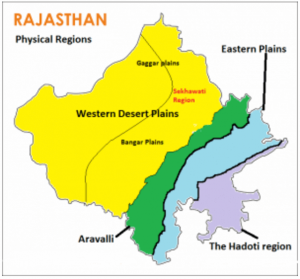
On the basis of the existing relief features, Rajasthan has been divided into the following physiographic divisions:
- Western Sandy Plains :
The surface of western Rajasthan is covered with vast stretches of sand occasionally interrupted by rocky protruding right up to the Pakistan border.
(a) Sandy Arid Plains
(i) Marusthali
(ii) Dune free Tract
(b) Semi-Arid Transitional Plains (Rajasthan Bagar)
(i) Luni Basin (Godwar Tract)
(ii) Plain of Interior Drainage (Sekhawati Tract)
(iii) Ghaggar Plain
63 per cent sand dune area of Rajasthan is concentrated in the desert districts of Barmer, Jaisalmer and Bikaner.
- Aravalli Range And Hilly Region
The principal and most dominant mountain range of Rajasthan is the Aravalli range. The Geological history of the Aravalli range can be traced back probably close of the dharwar times. This range runs diagonally across the State from northeast near Delhi and extends to southwest up to the Plains of Gujarat, for a distance of about 692 kilometers
- Aravalli Range and Bhorat Plateau
This division constitutes east Sirohi, nearly the whole of Udaipur except a narrow belt in the east and whole of Durgarpur district. The highest section of the Aravalli range known as ‘Bhorat’ Plateau lies northwest of Udaipur between Kumbhalgarh – Gogunda and the Average elevation of this plateau is 1,225 metres.
- Northeastern Hilly Region
Northern edge of Bhorat Plateau marks the boundary of north eastern hilly tract in the southwest. North of Kumbhalgarh, especially at the Alwar hills the elevation varies between 550 m to 670 m.
- Eastern Plains
The area on the northeast, east and southeast of the Aravalli range is known as the Eastern Plain. The Vindhyan Plateau marks the southeastern limit of the Plain. The western boundary is demarcated by the eastern edge of the Aravalli up to north of Udaipur.
- Banas Basin
The great watershed of India runs in an easterly direction starting From Udai Sagar, east of Udaipur. The watershed acts as the southern boundary of the Mewar Plains and south of this watershed is the Chappan Plain. The region is marked by various types of erosional features, produced in the granite and gneiss rocks mark the topography of the area.
- Chappan Plains
This plain drained by the tributaries of the Mahi River lies south of the great Indian watershed in southeastern Udaipur, Banswara and the southern part of Chittorgarh district. The Chappan area is deeply and intricately eroded resulting in the formation of separate hillocks, which is not identical to the Mewar plain in the north. This deeply dissected area is locally known as ‘Begaar’ and includes the hilly tracts of Banswara and Dungarpur.
- Southeastern Rajasthan Pathar (Hadoti Plateau)
The eastern part along the Chambal River is covered by the Hadoti Plateau. The Great Boundary Fault of the Aravallis forms its northwest boundary which extends eastward across the Rajasthan border. River Chambal drains the large part of this area. The Plateau has been divided into two smaller units:
- Vindhyan Scarpland
The scarps are facing towards the southsoutheast between the Banas and the Chambal and extend towards the east over Bundelkhand.
- Deccan Lava Plateau
The Deccan Lava Plateau is also known as ‘pathar (stony) or ‘uparmal’ plateau. It is a wide stony upland, including Kota-Bundi plateau section.
,
Rajasthan is a state in northwestern India. It is the largest state in India by area, covering 342,239 square kilometers (132,139 sq mi). The state is bordered by Haryana and Punjab to the north, Uttar Pradesh to the northeast, Madhya Pradesh to the east, Gujarat to the south, and Pakistan to the west. The capital of Rajasthan is Jaipur.
The relief and structure of Rajasthan can be divided into the following subtopics:
- Aravalli Range: The Aravalli Range is a mountain range that runs through the state of Rajasthan. It is the oldest mountain range in India and is composed of granite and gneiss. The Aravalli Range is a popular tourist destination, with several hill stations and temples located in the range.
- Thar Desert: The Thar Desert is a desert that covers most of the northwestern part of Rajasthan. It is the largest hot desert in India and is known for its sand dunes, scrub forests, and wildlife. The Thar Desert is home to several important cities, including Jaisalmer, Jodhpur, and Bikaner.
- Ganges Basin: The Ganges Basin is a river basin that covers most of the northern part of Rajasthan. It is the largest river basin in India and is home to the Ganges River, which is one of the most sacred rivers in Hinduism-2/”>Hinduism. The Ganges Basin is a major agricultural region, with rice and wheat being the main crops.
- Central Highlands: The Central Highlands are a region of highlands that covers the central part of Rajasthan. They are composed of sandstone and shale and are home to several important cities, including Jaipur, Jodhpur, and Udaipur. The Central Highlands are a popular tourist destination, with several forts and palaces located in the region.
- Western Plateau: The Western Plateau is a region of plateaus that covers the western part of Rajasthan. It is composed of limestone and dolomite and is home to several important cities, including Ajmer and Bikaner. The Western Plateau is a major agricultural region, with wheat and barley being the main crops.
- Eastern Plains: The Eastern Plains are a region of plains that covers the eastern part of Rajasthan. They are composed of alluvial Soil and are home to several important cities, including Kota and Bharatpur. The Eastern Plains are a major agricultural region, with rice and wheat being the main crops.
The Climate-of-rajasthan/”>Climate of Rajasthan is hot and dry, with an average temperature of 27 degrees Celsius (81 degrees Fahrenheit). The monsoon season runs from June to September, and brings most of the state’s annual rainfall. The Thar Desert is the driest region in Rajasthan, with an average annual rainfall of less than 100 millimeters (4 inches). The Central Highlands and Western Plateau receive more rainfall than the Thar Desert, with an average annual rainfall of 200 to 300 millimeters (8 to 12 inches). The Eastern Plains receive the most rainfall in Rajasthan, with an average annual rainfall of 400 to 500 millimeters (16 to 20 inches).
The Vegetation of Rajasthan varies depending on the climate and soil type. The Thar Desert is home to scrub forests and grasslands. The Central Highlands and Western Plateau are home to deciduous forests. The Eastern Plains are home to tropical forests.
The wildlife of Rajasthan is diverse, with a variety of animals found in the state’s different Ecosystems. The Thar Desert is home to blackbuck, chinkara, and desert foxes. The Central Highlands and Western Plateau are home to tigers, leopards, and sloth bears. The Eastern Plains are home to elephants, rhinoceroses, and tigers.
Rajasthan is a beautiful and diverse state with a rich history and culture. The state’s relief and structure, climate, vegetation, and wildlife make it a popular tourist destination.
What is the relief and structure of Rajasthan?
Rajasthan is a state in northwestern India. It is the largest state in India by area, covering 342,239 square kilometers (132,140 sq mi). The state is bordered by Punjab to the north, Haryana and Uttar Pradesh to the northeast, Madhya Pradesh to the east, Gujarat to the southeast, and Pakistan to the west. The capital of Rajasthan is Jaipur.
The relief and structure of Rajasthan is characterized by a number of different Landforms, including Mountains, plateaus, and deserts. The Aravalli Range, a mountain range that runs through the state, is the most prominent Landform in Rajasthan. The Aravalli Range is a part of the Indian Shield, which is the oldest geological formation in India. The Aravalli Range is home to a number of important historical and cultural sites, including the Mehrangarh Fort in Jodhpur and the Hawa Mahal in Jaipur.
The Thar Desert, the largest desert in India, is located in the northwestern part of Rajasthan. The Thar Desert is a hot, dry desert with a sparse Population. The desert is home to a number of different wildlife species, including camels, snakes, and lizards.
The plateaus of Rajasthan are located in the central and southern parts of the state. The plateaus are characterized by their flat, open terrain. The plateaus are home to a number of important agricultural areas, including the Malwa Plateau and the Shekhawati Plateau.
What are the major rivers in Rajasthan?
The major rivers in Rajasthan are the Chambal River, the Banas River, the Luni River, and the Sutlej River. The Chambal River is the longest river in Rajasthan. The Chambal River is a tributary of the Yamuna River. The Banas River is the second longest river in Rajasthan. The Banas River is a tributary of the Chambal River. The Luni River is the third longest river in Rajasthan. The Luni River is a tributary of the Arabian Sea. The Sutlej River is the fourth longest river in Rajasthan. The Sutlej River is a tributary of the Indus River.
What are the major cities in Rajasthan?
The major cities in Rajasthan are Jaipur, Jodhpur, Udaipur, Kota, and Bikaner. Jaipur is the capital of Rajasthan. Jaipur is a city with a rich history and culture. Jodhpur is a city in the Thar Desert. Jodhpur is known for its forts and palaces. Udaipur is a city on the banks of Lake Pichola. Udaipur is known for its palaces and temples. Kota is a city on the banks of the Chambal River. Kota is known for its military academy. Bikaner is a city in the Thar Desert. Bikaner is known for its forts and palaces.
What are the major tourist attractions in Rajasthan?
The major tourist attractions in Rajasthan are the Hawa Mahal, the Mehrangarh Fort, the City Palace, the Amber Fort, and the Jal Mahal. The Hawa Mahal is a palace in Jaipur. The Hawa Mahal is known for its intricate latticework. The Mehrangarh Fort is a fort in Jodhpur. The Mehrangarh Fort is one of the largest forts in India. The City Palace is a palace in Jaipur. The City Palace is a complex of palaces and gardens. The Amber Fort is a fort in Amber. The Amber Fort is a hilltop fort that offers stunning views of the surrounding countryside. The Jal Mahal is a palace in Udaipur. The Jal Mahal is a palace that is partially submerged in Lake Pichola.
What are the major festivals in Rajasthan?
The major festivals in Rajasthan are the Teej Festival, the Pushkar Camel Fair, the Gangaur Festival, and the Holi Festival. The Teej Festival is a festival that celebrates the love between husband and wife. The Pushkar Camel Fair is a fair that is held in the city of Pushkar. The Gangaur Festival is a festival that celebrates the return of the goddess Ganga to earth. The Holi Festival is a festival that celebrates the arrival of spring.
Which of the following is not a type of soil found in Rajasthan?
(A) Black soil
(B) Red soil
(C) Alluvial soil
(D) Desert soilWhich of the following is the largest district in Rajasthan?
(A) Jaisalmer
(B) Jodhpur
(C) Jaipur
(D) BikanerWhich of the following is the capital of Rajasthan?
(A) Jaipur
(B) Jodhpur
(C) Jaisalmer
(D) BikanerWhich of the following is the highest peak in Rajasthan?
(A) Guru Shikhar
(B) Mount Abu
(C) Aravalli Range
(D) None of the aboveWhich of the following is the largest lake in Rajasthan?
(A) Sambhar Lake
(B) Pichola Lake
(C) Jaisamand Lake
(D) None of the aboveWhich of the following is the national animal of Rajasthan?
(A) Tiger
(B) Lion
(C) Leopard
(D) None of the aboveWhich of the following is the national bird of Rajasthan?
(A) Peacock
(B) Eagle
(C) Vulture
(D) None of the aboveWhich of the following is the national flower of Rajasthan?
(A) Lotus
(B) Rose
(C) Lily
(D) None of the aboveWhich of the following is the national tree of Rajasthan?
(A) Peepal tree
(B) Banyan tree
(C) Ashoka tree
(D) None of the aboveWhich of the following is the national fruit of Rajasthan?
(A) Mango
(B) Apple
(C) Grapes
(D) None of the above