Rajasthan Cropping Pattern
Cropping pattern means the proportion of area under various crops at a point of time. The crop statistics published by the governments are used to denote the cropping patterns. Cropping pattern is, however, a dynamic concept as it changes over space and time.The cropping patterns of a region are closely influenced by the geo-climatic, socio-cultural, economic, historical and political factors. The physical Environment (physiographic, Climate, soils and water) imposes limits on the Growth and distribution of Plants and animals.
Depending on the terrain, topography, slope, temperature, amount and reliability of rainfall, soils and availability of water for Irrigation, the cropping patterns varyfrom region to region.
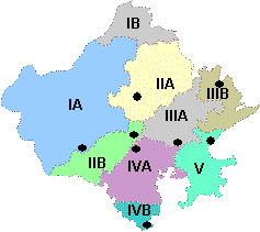
Agro Climatic Zones of Rajasthan
| Zone | Area | Total
Area (million ha) | District Covered | Average Rainfall (mm) | Temp OC | Major Crops | Soils | agriculture Research Station | ||
| Max. | Min | Kharif | Rabi | |||||||
| IA | Arid western plain | 4.74 | Barmer & part of Jodhpur | 200-370 | 40.0 | 8.0 | Pearlmillet Mothbean Sesame | Wheat, Mustard, Cumin | Desert soils and sand dunes aeolian Soil, coarse sand in texture some places calcareous | Mandore, Jodhpur |
| IB | Irrigated north western plain | 2.10 | Sriganganagar, Hanumangarh | 100-350 | 42.0 | 4.7 | Cotton, Clusterbean | Wheat, Mustard, Gram | Alluvial deposites calcareous, high soluble salts & exchangeable sodium | Ganganagar |
| IC | Hyper arid partial irrigated zone | 7.70 | Bikaner, Jaisalmer, Churu | 100-350 | 48.0 | 3.0 | Pearlmillet Mothbean Clusterbean | Wheat, Mustard, Gram | Desert soils and sand dunes aeolian soil, loamycoarse in texture & calcareous | Beechwal Bikaner |
| IIA | Internal drainage dry zone | 3.69 | Nagaur, Sikar, Jhunjhunu, Part of Churu | 300-500 | 39.7 | 5.3 | Pearlmillet Clusterbean Pulses | Mustard, Gram | Sandy loam, sallow depth red soils in depressions | Fatehpur, Sikar |
| IIB | Transitional plain of Luni basin | 3.00 | Jalore, Pali, Part of Sirohi, Jodhpur | 300-500 | 38.0 | 4.9 | Pearlmillet Clusterbean sesame | Wheat, Mustard | Red desert soils in Jodhopur, Jalore & Pali sierzems in Pali & Sirohi | Keshwana, Jalore |
| IIIA | Semi arid eastern plains | 2.96 | Jaipur, Ajmer, Dausa, Tonk | 500-700 | 40.6 | 8.3 | Pearlmillet Clusterbean Sorghum | Wheat, Mustard, Gram | Sierozens, eastern part alluvial, west north west lithosols, foot hills, brown soils | Durgapura, Jaipur |
| IIIB | Flood prone eastern plain | 2.77 | Alwar, Dholpur, Bharatpur, Karoli, S.Madhopur | 500-700 | 40.0 | 8.2 | Pearlmillet Clusterbean Groundnut | Wheat, Barley, Mustard, Gram | Alluvial prone to Water Logging, nature of recently alluvial calcareous has been observed | Navgaun, Alwar |
| IVA | Sub-humid southern plains | 3.36 | Bhilwara, Sirohi, Udaipur, Chittorgarh | 500-900 | 38.6 | 8.1 | Maize, Pulses, Sorghum | Wheat, Gram | Soil are lithosolsat foot hills & alluvials in plains | Udaipur |
| IVB | Humid sothern plains | 1.72 | Dungarpur, Udaipur, Banswara, Chittorgarh | 500-1100 | 39.0 | 7.2 | Maize, Paddy Sorghum Blackgram | Wheat, Gram | Predominantly reddish medium texture, well drained calcareous, shallow on hills, deep soils in valleys | |
| V | Humid south eastern plain | 2.70 | Kota, Jhalawar, Bundi, Baran | 650-1000 | 42.6 | 10.6 | Sorghum Soyabean | Wheat, Mustard | Black of alluvial origin, clay loam, groundwater salinity | Ummedganj, Kota |
Land-Use pattern in Rajasthan state
S.N Land Use Details Area (in lakh hactare)
1 Total Geographical area 342.66
2 Forest 26.60
3 Non agriculture use 17.60
4 Barren & unculturable land 24.98
5 Area unfit for cultivation (3+4) 42.59
6 Cultivable wasteland 45.46
7 Pasture 17.08
8 Land under misc trees crops& groves 0.14
9 Uncultivated land excluding fallows (6+7+8) 62.69
10 Fallow 36.82
11 Net Area sown 173.94
12 Gross area sown 216.64
13 Net area Irrigated 52.39
14 Gross Area irrigated 63.93
15 Cultivable land(6+10+11) 256.22
16 Rainfed cultivable land (6+10+11-13) 203.83
- Culturable Wasteland is highest in Ajmer, Alwar and Jaisalmer and minimum at Hanumangarh, Jhunjhunu and Bharatpur. Fallow lands other than current fallow cover the highest area in Alwar, Ajmer and Jodhpur whereas they are lowest at Karauli, Dholpur and Bharatpur. The current fallow land covers the highest area in Ajmer, Alwar and Barmer whereas the lowest are at Karauli, Banswara and Rajsamand.
- Under the category of Net Area Sown and Net Area Sown more than once Ajmer and Alwar stand on the top two positions with Barmer and Hanumangarh at the third positions respectively. Dhoplur, Dungarpur and Rajsamand are the lowest three in the category of Net Area Sown and Dungarpur, Sirohi and Rajsamand are the last three of Net Area Sown more than once.
- It can be seen that the western districts of Jaisalmer, Bikaner and Barmer have large stretches of Sandy soils therefore a very high Percentage of cultivable waste and fallow land is present in the region. The net sown area is also less than the other types of land uses here. Higher percentage of seasonal pasture lands exist in Barmer, Jodhpur, Jalore and Nagaur districts. Generally, Forest areas are evidently absent in the entire western Rajasthan Churu, Nagaur, Jodhpur, Pali and Jalore districts lying in the mid western districts of arid and the semi arid zone support only Rain-fed Crops in this area and because of low rainfall the percentage of fallow land is quite high. The net sown area is the highest in the semi-arid zone and the sub-humid parts of eastern Rajasthan which also accounts for extensive agriculture. Due to the presence of hilly terrain in parts of Bhilwara, Chittorgarh, Udaipur, Kota and Baran districts the percentage of cultivable waste and the land put to non agricultural use is highest.
,
Rajasthan is a state in northwestern India. It is the largest state in India by area, covering 342,239 square kilometers (132,139 sq mi). The state is located in the Thar Desert, and has a Population of over 70 million people. The capital of Rajasthan is Jaipur.
The main crops grown in Rajasthan are wheat, rice, cotton, and bajra. Other important crops include barley, mustard, gram, and sugarcane. Rajasthan is also a major producer of milk, meat, and eggs.
The cropping pattern in Rajasthan varies depending on the season. Rabi Crops are grown during the winter season, from October to March. Kharif Crops are grown during the monsoon season, from June to September. Summer crops are grown during the hot season, from April to May.
Fodder crops are grown to feed Livestock. Oilseed crops are grown to produce oil, which is used in cooking and for other purposes. Pulses crops are grown to produce pulses, which are a type of legume. Cereals crops are grown to produce grains, such as wheat, rice, and barley. Vegetables crops are grown to produce vegetables, such as tomatoes, onions, and potatoes. Fruits crops are grown to produce fruits, such as mangoes, oranges, and apples. Spices crops are grown to produce spices, such as turmeric, chili peppers, and ginger. Medicinal crops are grown to produce medicinal herbs. Industrial crops are grown to produce raw materials for industries, such as cotton and sugarcane. Cash Crops are grown to produce crops that can be sold for a profit, such as wheat and rice.
The cropping pattern in Rajasthan is affected by a number of factors, including climate, soil type, water availability, and government policies. The climate in Rajasthan is hot and dry, which limits the types of crops that can be grown. The soil in Rajasthan is mostly sandy, which also limits the types of crops that can be grown. Water availability is a major constraint on agriculture in Rajasthan. The state receives very little rainfall, and most of the water for irrigation comes from groundwater. Government policies also play a role in the cropping pattern in Rajasthan. The government provides subsidies for certain crops, such as wheat and rice. This encourages farmers to grow these crops, even if they are not the most profitable crops to grow.
The cropping pattern in Rajasthan is constantly changing. New crops are being introduced, and old crops are being abandoned. This is due to a number of factors, including Climate Change, technological advances, and changing market conditions. Climate change is making it more difficult to grow certain crops in Rajasthan. For example, the wheat crop is being affected by rising temperatures. Technological advances are making it possible to grow new crops in Rajasthan. For example, Drip Irrigation is making it possible to grow crops in areas with limited water Resources. Changing market conditions are also affecting the cropping pattern in Rajasthan. For example, the demand for organic food is increasing, which is encouraging farmers to grow organic crops.
The cropping pattern in Rajasthan is an important part of the state’s economy. Agriculture employs over 50% of the state’s workforce. The cropping pattern also affects the state’s environment. The use of pesticides and Fertilizers can pollute the water and soil. The clearing of land for agriculture can lead to deforestation. The cropping pattern in Rajasthan is a complex issue that is affected by a number of factors. It is important to understand the factors that affect the cropping pattern in order to develop sustainable agricultural practices.
What is the cropping pattern?
The cropping pattern is the mix of crops that are grown in a particular area. It is determined by a number of factors, including climate, soil type, water availability, and market demand.
What are the different types of cropping patterns?
There are two main types of cropping patterns: annual cropping and perennial cropping. Annual cropping systems involve growing a different crop each year, while perennial cropping systems involve growing the same crop for several years.
What are the advantages and disadvantages of each type of cropping pattern?
Annual cropping systems have the advantage of being able to respond to changes in market demand. However, they also have the disadvantage of being more susceptible to pests and diseases. Perennial cropping systems are less susceptible to pests and diseases, but they also have the disadvantage of being less responsive to changes in market demand.
What are the factors that influence the cropping pattern?
The cropping pattern is influenced by a number of factors, including climate, soil type, water availability, and market demand. Climate is the most important factor, as it determines the types of crops that can be grown in a particular area. Soil type is also important, as it affects the growth of crops. Water availability is important, as crops need water to grow. Market demand is important, as farmers will only grow crops that they can sell.
What are the challenges of cropping pattern?
The main challenges of cropping pattern are pests and diseases, climate change, and water scarcity. Pests and diseases can damage crops, leading to crop losses. Climate change can affect the growth of crops, leading to crop failures. Water scarcity can limit the amount of crops that can be grown.
What are the solutions to the challenges of cropping pattern?
The solutions to the challenges of cropping pattern include using resistant varieties of crops, using integrated pest management, using climate-resilient crops, and using water-efficient irrigation methods.
What is the future of cropping pattern?
The future of cropping pattern is uncertain. Climate change is expected to make it more difficult to grow crops in some areas. Water scarcity is also expected to become a major problem. As a result, farmers will need to find ways to adapt to these challenges.
Which of the following is not a major crop grown in Rajasthan?
(A) Wheat
(B) Rice
(C) Maize
(D) CottonThe main reason for the low agricultural productivity in Rajasthan is:
(A) Lack of irrigation facilities
(B) Unsuitable soil conditions
(C) Low rainfall
(D) All of the aboveThe main irrigation source in Rajasthan is:
(A) Canals
(B) Wells
(C) Tanks
(D) Tube wellsThe main type of soil found in Rajasthan is:
(A) Alluvial soil
(B) Black soil
(C) Red soil
(D) Desert soilThe main crops grown in the arid region of Rajasthan are:
(A) Bajra
(B) Jowar
(C) Maize
(D) All of the aboveThe main crops grown in the semi-arid region of Rajasthan are:
(A) Wheat
(B) Rice
(C) Cotton
(D) All of the aboveThe main crops grown in the sub-humid region of Rajasthan are:
(A) Sugarcane
(B) Oilseeds
(C) Fruits
(D) All of the aboveThe main livestock reared in Rajasthan are:
(A) Camels
(B) Sheep
(C) Goats
(D) All of the aboveThe main mineral found in Rajasthan is:
(A) Petroleum
(B) Coal
(C) Gypsum
(D) All of the aboveThe main Industry in Rajasthan is:
(A) Mining
(B) Manufacturing
(C) Tourism
(D) All of the above