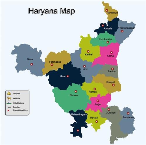
Geographical location of Haryana
- Haryana is a State in the northwest of India and was carved out of the Indian State of Punjab on 1st November 1966.
- With capital at Chandigarh which is administered as a Union Territory, this north Indian land locked state is located between 27º 39′ and 30º 35’N latitude and between 74º27′ and 77º36′ E longitude with just 1.37% of the total geographical area and less than 2% of India’s Population.
- Almost 1/3 of the total area of the state falls in the National Capital Region. Haryana is an agrarian state whereas 85% of its area is under cultivation, engaging about 78% of its population in agriculture.
- Haryana has carved a place of distinction for itself during the past three decades, whether it is agriculture or Industry, canal Irrigation or rural electrification.
- Haryana is among the most prosperous states in India, having one of the highest per capita incomes in the country
Geography of Haryana
Haryana has four main geographical features.
- Shivalik Hills to the north east
- Ghaggar Yamuna Plain forming the largest part of the state
- Semi- desert sandy plain in the south west
- Aravalli hills in the south.
Shivalik Hills:
- These hills are the source of the rivers like Saraswati, Ghaggar, Tangri and Markanda. Parts of Panchkula, Ambala and Yamunanagar districts.
Aravali hills: This is a dry irregular hilly area.
Semi-desert sandy plain:
- This area includes the districts of Sirsa and parts of Hissar, Mahendergarh, Fatehbad, Bhiwani and Shares border with Rajasthan.
Ghaggar Yamuna Plain:
- Divided in 2 parts – the higher one is called ‘Bangar’ and the lower ‘Khadar’.
- This alluvium plain is made up of sand, clay, silt and hard calcareous balls like gravel known locally as kankar
Physiographic profile of Haryana
- Physiography of Haryana sub-region mainly consists of plains made up of alluvium of Yamuna River with some pediments of Aravali.

- Almost all the districts of sub-region have similar characteristics except areas dominated by Aravali.
Panipat District
- Panipat district is a part of alluvial plain of Yamuna river.
- It slopes from west to east and water of the area flows towards Yamuna.
- Out of the two major physiographic units in the area, the flood plains are suitable for cultivation of rice and sugarcane.
- The other unit i.e. older alluvial plain spreading in the western part of the district is inclined towards the south and south-west area is irrigated by tube wells and canals and is a prosperous agricultural area.
Sonipat district
- Sonipat district may roughly be divided physiographically into three regions: The Khadar, the upland plain and the sandy region.
Rohtak district
- Rohtak district comprises of the vast IndoGangetic alluvial plains called older alluvial plain.
- This older alluvial plain is further divided into sand derived from the old alluvial plains is mostly from the Himalayan rivers having a heterogeneous composition.
Jhajjar district
- Jhajjar district comprises of vast Indo-Gangetic alluvial plains.
- The main physiographic components are
- Upland plains, being spread in the northeastern part of the district, covered with old alluvium Soil possessing high productivity characteristics
- Alluvial Plains which are productive soils with good irrigation facilities (canal and tube-wells).
Rewari district
- Rewari district can be divided into four terrains i.e.
- Barren rocky/stony waste/sheet rocky
- Sandy plain with sand dunes
- Old flood plains
- Occasional hillocks and Undulating uplands with or without scrub.
- The Aravali are presently experiencing weathering and denudation.
Gurgaon district
- Gurgaon district comprises of both hills on one hand and depressions on the other, forming irregular and diverse nature of topography.
- Two ridges (i) the Firozepur-Jhirka Delhi ridge forms the western boundary and (ii) the Delhi ridge forms the eastern boundary of the district.
Mewat district
- Mewat district has distinct topographic features with flat alluvial plains over most of the region, long and narrow pediments and local undulations caused by windblown sands at the foot hill zones and the plains.
Faridabad and Palwal districts
- Faridabad and Palwal districts have mountainous physiography and have alluvium deposits.
- The alluvial plains have been divided into two units.
- Khadar that is the low lying flood plain of newer alluvium and Banger, an upland plain made of older alluvial and is spread towards west.
- There are also few artificial lakes namely Surajkund, Badhkal, Peacock and Dhauj Lake etc
,
Haryana is a state in northern India. It is bordered by Punjab to the north, Himachal Pradesh to the east, Uttarakhand to the northeast, Uttar Pradesh to the south, Rajasthan to the southwest, and Delhi to the west. The state has an area of 44,212 square kilometers (17,075 sq mi) and a population of 28.8 million as of 2020. The capital of Haryana is Chandigarh, which is also the joint capital of the neighboring state of Punjab.
Haryana is a landlocked state with a varied topography. The northern part of the state is mountainous, while the southern part is plain. The highest point in Haryana is Chaurichand Peak, which is located in the Shivalik Hills. The Yamuna River flows through the state from east to west.
The Climate-of-haryana/”>Climate of Haryana is tropical continental, with hot summers and cold winters. The Average temperature in January is 10 degrees Celsius (50 degrees Fahrenheit), while the average temperature in July is 38 degrees Celsius (100 degrees Fahrenheit). The state receives an average annual rainfall of 700 millimeters (28 inches).
Haryana is a major agricultural state. The main crops grown in the state are wheat, rice, sugarcane, and Cotton. The state is also home to a number of industries, including manufacturing, electronics, and pharmaceuticals.
Haryana is a culturally diverse state. The majority of the population is Hindu, but there are also significant Muslim, Sikh, and Christian minorities. The state is home to a number of historical and religious sites, including the Kurukshetra War Site, the Karnal Fort, and the Surajkund Mela.
Haryana is a rapidly developing state. The state has a young population and a growing economy. The state is also home to a number of educational institutions, including the Indian Institute of Technology Roorkee, the Panjab University, and the Maharshi Dayanand University.
Haryana is a beautiful and vibrant state with a rich history and culture. The state is home to a number of natural and man-made attractions, making it a popular tourist destination.
What is Haryana known for?
Haryana is known for its agriculture, Dairy, and manufacturing industries. It is also home to the ancient city of Kurukshetra, which is a major pilgrimage site for Hindus.
What is the capital of Haryana?
The capital of Haryana is Chandigarh.
What is the population of Haryana?
The population of Haryana is over 28 million people.
What is the language spoken in Haryana?
The Official Language of Haryana is Hindi, but Punjabi and Haryanvi are also widely spoken.
What is the religion of Haryana?
The majority of people in Haryana are Hindu, followed by Muslims and Sikhs.
What is the climate of Haryana?
The climate of Haryana is hot and dry in the summer, and cold and dry in the winter.
What is the economy of Haryana?
The economy of Haryana is based on agriculture, dairy, and manufacturing.
What are some of the tourist attractions in Haryana?
Some of the tourist attractions in Haryana include the ancient city of Kurukshetra, the Pinjore Gardens, and the Surajkund Mela.
What are some of the famous people from Haryana?
Some of the famous people from Haryana include the cricketer Kapil Dev, the actor Dharmendra, and the politician Bansi Lal.
What are some of the challenges facing Haryana?
Some of the challenges facing Haryana include POVERTY, illiteracy, and pollution.
What are some of the opportunities for Haryana?
Some of the opportunities for Haryana include its growing economy, its skilled workforce, and its strategic location.
What is the future of Haryana?
The future of Haryana is bright. The state is poised for continued economic Growth, and its people are determined to improve their lives.
1. Which of the following is not a state in India?
(A) Haryana
(B) Punjab
(C) Himachal Pradesh
(D) Uttar Pradesh
2. Which of the following is the capital of Haryana?
(A) Chandigarh
(B) Panchkula
(C) Faridabad
(D) Gurugram
3. Which of the following is the largest city in Haryana?
(A) Faridabad
(B) Gurugram
(C) Gurgaon
(D) Noida
4. Which of the following is the official language of Haryana?
(A) Hindi
(B) Punjabi
(C) English
(D) Urdu
5. Which of the following is the chief minister of Haryana?
(A) Manohar Lal Khattar
(B) Bhupinder Singh Hooda
(C) Om Prakash Chautala
(D) Devi Lal
6. Which of the following is the population of Haryana?
(A) 28,350,000
(B) 29,350,000
(C) 30,350,000
(D) 31,350,000
7. Which of the following is the Literacy rate of Haryana?
(A) 75.6%
(B) 76.6%
(C) 77.6%
(D) 78.6%
8. Which of the following is the sex ratio of Haryana?
(A) 879
(B) 889
(C) 899
(D) 909
9. Which of the following is the GDP of Haryana?
(A) $100 billion
(B) $110 billion
(C) $120 billion
(D) $130 billion
10. Which of the following is the agricultural land of Haryana?
(A) 70%
(B) 75%
(C) 80%
(D) 85%
11. Which of the following is the industrial land of Haryana?
(A) 15%
(B) 20%
(C) 25%
(D) 30%
12. Which of the following is the service land of Haryana?
(A) 15%
(B) 20%
(C) 25%
(D) 30%
13. Which of the following is the main crop of Haryana?
(A) Wheat
(B) Rice
(C) Cotton
(D) Sugarcane
14. Which of the following is the main industry of Haryana?
(A) Automobile
(B) Electronics
(C) Engineering
(D) Textile
15. Which of the following is the main tourist attraction of Haryana?
(A) Pinjore Gardens
(B) Surajkund Mela
(C) Kurukshetra War Memorial
(D) all of the above