Drainage System and River of Sikkim
- Sikkim is a small Himalayan state in north-east India situated between 27degree 00’ 46″ to 28 degree 07’ 48″ N latitude and 88 degree 00’ 58″ to 88 degree 55’ 25″E longitude with geographical area of 7,096 sq km constituting only 0.22% of total geographical area of India.
- It has a human Population of 5,40,493 as per Census, 2001, which constitutes only 0.05% of India’s total population.
- The state is somewhat rectangular in shape with maximum length from north to south of about 112 km and maximum width of 90 km from east to west.
- Sikkim is bounded in the north by the Tibetan plateau, by China (Tibet) on the northeast, by Pangola range of Bhutan on the southeast, by Darjeeling district of West Bengal on the south and Singalila range and Mt. Khangchendzonga on the west and northwest.
- Entire state of Sikkim constitutes upper basin of Teesta river except for a small area of 75.62 sq km in extreme southeast that of Jaldhaka river, which originates in East Sikkim and flows through West Bengal parallel to Teesta river to meet Brahmaputra river.

- In southernmost part of Sikkim, Teesta river flows in southwest direction and defines the inter-state boundary between Sikkim and West Bengal up to Melli Bazar where it is joined by Rangit river which drains West Sikkim district.
- Rangit river, the largest tributary of Teesta river in Sikkim, from Naya Bazar point flows in southeast direction and marks the interstate boundary between Sikkim and West Bengal in the southwest.
Teesta River
- One of the rivers that almost flow right across the length of Sikkim is the Teesta.
- It’s major tributary is the Rangeet which originates from the Rathong Glacier, meets it at the border between Sikkim and West Bengal.
- Teesta originates from the Cholamu lake where Teesta is hardly a stream.
- No one can imagine that this innocuous looking stream would transform into a thundering mighty river less than a hundred kilometers downstream.
- The source of the Teesta is the pristine Tso Lhamu Lake in North Sikkim, some 5,300 metres above sea level.
- The glacial waters then move downwards to meet Zemu Chu just above Lachen village and then rushing down deep gorges it meets Lhachung Chu at Chungthang.
- At Mangan, the river is joined by the Talung Chu as it continues its journey down, finally reaching Singtam in East Sikkim, becoming slower and widening to almost double its width.
- Further down at Melli, the Teesta merges with the river Rangeet which is born of the Rathong glacier in West Sikkim, before entering the plains of North Bengal and eventually joining Brahmaputra in Bangladesh.
- During monsoons the otherwise innocuous looking rivers of Sikkim become swollen, swift, muddy and dangerous.
- The rivers are narrow, serpentine and full of rocks and hence are not navigable.
- Because of swift currents hitting rocks, the rivers are very noisy and can be heard for miles together.
- The Teesta finally joins the Bhramaputra in Bangladesh.
- The rivers are fed by snow melting on the Mountains as well as rain that accumulates in the catchment areas during the monsoons.
- Human settlements usually must exist above the level of rivers and hence even if flooding takes place life and property remain safe.
The Rangeet or Rangit
- It is a tributary of the Teesta river, which is the largest river in the Indian state of Sikkim.
- The Rangeet river originates in the Himalayanmountains in West Sikkim The river also forms the boundary between Sikkim and Darjeeling district.
- A perennial river, it is fed by the melting snow of the Himalayas in early summer and the monsoonrains in June–September.
- It is popular among rafting enthusiasts owing to its turbulent waters.
- The river flows past the towns of Jorethang, Pellingand Legship.
- During its final few kilometres, it joins the TeestaRiver at a confluence known as Tribeni, which is a popular picnic spot.
- The Rangeet River has an NHPChydropower plant with the capacity of 60 megawatts (80,000 hp) capacity in Sikkim.
River Rangpo
- It is a river in the Indian state of Sikkim.
- A tributary of the Teesta River, it is fed by the Rangpo chu.
- The town of Rangpo in Sikkim lies on River Rangpo north bank.
- The river forms the border between Sikkim and West Bengal states at Rangpo town.
- There is no separate name for the town in West Bengal that lies on south bank of the river and therefore it is also called Rangpo.
- The river runs through most of East Sikkim and a few parts of the Darjeeling District of North Bengal.
- This tributary flows mainly from east to west with a variable channel pattern including braided, meandering, straight, gorge and blocked lake.
- Landslides are very common along the river bank as cliff-like bedrocks are considerably exposed along the river valley wall.
- Its confluence with Teesta River is immediately downstream of Rangpo town.
The Talung River
- It is an east-south east flowing river in the North Sikim Himalayas.
- It originates at the Talung-Tonsyong Glacier’s confluenceat the meeting point of Talung and Tongshiong River & then flows east south east to meet the River Teesta near Singhik, North Sikkim of India.
- The upper catchment is fed by a number of streams and rivulets.
- These streams & rivulets flow from the southern part of Simvu-Sinialchu region to meet the main river.
- Another tributary which feeds the main stream flows from the Zorpetam mountain valley.
- Zorepetam valley is a typical inaccessible mountain terrain in the east of Pandim and Tinchenkhang.
- Number of River of Sikkim originates from this region.
- Owing to the complexity of the river systems its name in its catchment area changes from place to place.
- According to records it is Rukel Chu at first, then Rungayang or Rongyoung Chu and thereafter Talung River or Tholung Chu till its confluence
The Jaldhaka River
- It is also known as Dichu River in earlier times, is a trans-boundary river with a length of 192 kilometres that originates from the Kupup or Bitang Lake in southeastern Sikkim in the eastern Himalayas and flows through Bhutan and the Kalimpong, Jalpaiguri and Cooch Behar districts of West Bengal, India.
- At that point the river enters Bangladesh through the Lalmonirhat District and then joins with the Dharla River until the Dharla debouches into the Brahmaputra River near the Kurigram District.
- Due to the river’s wandering over several international borders, only a small length of the river lies within Bangladesh
The Lachen River
- It is a tributary of the Teesta River in the state of Sikkim, India.
- It is one of the two main tributaries of the Teesta along with the Lachung River, which rise on opposite sides of the Donga Rangein neighbouring Bhutan and converge in Chungthang in the North Sikkim district.
The Lachung River
- Itis a tributary of the Teesta River located in the North Indian state of Sikkim.
- It is a chief tributary of the Teesta, which is an important river in Sikkim along with Rangeet River.
- The village of Lachungis perched on the craggy bank of the river approximately 23 kilometres from Chungthang. It is at Chungthang where the Lachung and Lachen rivers converge and give rise to the Teesta.
- The river is 2,500 metres (8,200 ft) above sea level.
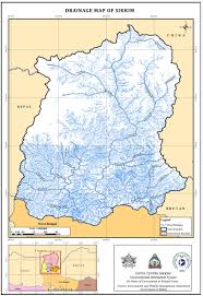
Drainage systems, also known as river systems, are the patterns formed by the streams, rivers, and lakes in a particular drainage basin. They are governed by the topography of the land, whether a particular region is dominated by hard or soft rocks, and the gradient of the land.
Teesta River Basin Information
- The river Teesta is one of the main Himalayan rivers and originates from the Glaciers of Sikkim in North at an elevation of about 5,280 m.
- The river rises in mountainous terrain in extreme north as Chhombo Chhu, which flows eastward and then southward to be joined by Zemu Chhu, upstream of Lachen village near Zema.
- The river takes a gentle turn in southeast direction and meets Lachung Chhu at Chungthang where it takes the form of a mighty Himalayan river.
 Irrigation-Project-in-Bangladesh-224×300.png” alt=”Drainage system and River of Sikkim” width=”224″ height=”300″ />
 - Teesta, therefore, is the main river of the state with its several tributaries viz. Zemu Chhu, Lachung Chhu, Rangyong Chhu, Dik Chhu, Rani Khola, Rangpo Chhu and Rangit river and constitutes an extremely important resource of the state.
- After the confluence of Teesta river and Lachung Chhu at Chungthang, the river gradually widens and takes a strong westward turn upstream of Tong and after flowing down to Singhik, the river drops from 1,550 m to 750 m.
- At Singhik, the river receives one of its major tributaries, Rangyong Chhu on its right bank, which originates from the Talung glacier, a part of the Khangchendzonga mountain range.
- From Singhik, the river flows southwards to Dikchu with a 200 m drop through a very deep valley for about 30 km.
- From Dikchu onwards, the river takes many sharp and wide curves and flows down to Singtam with a further drop of about 200m.
- Rangpo Chhu, which drains the Chhangu lake area in East Sikkim joins Teesta river on its left bank at Rangpo. Downstream of Rangpo, Teesta river widens and is joined by Rangit river at Melli Bazar on Sikkim-West Bengal border.
- From Melli Bazar downstream, the river leaves the hilly terrain and enters the plains of West Bengal at Sevoke near Siliguri. Teesta river ultimately drains into Brahmaputra at Teestamukh Ghat (Kamarjani-Bahadurabad in Rangpu district of Bangladesh) and traverses a distance of about 400 km from its origin.
- Teesta and most of its tributaries are flashy mountain rivers and carry boulders and considerable quantity of sediment. The flow is turbulent and characterised by high velocities.
- Throughout its course in Sikkim, Teesta and its tributaries flow in very narrow and deep valleys having precipitous hill slopes, except where the tributaries join the main stream.
- The hill slopes are mostly friable and landslips are very common throughout the basin.
 Irrigation-Project-in-Bangladesh-224×300.png” alt=”Drainage system and River of Sikkim” width=”224″ height=”300″ />
WATERSHEDS OF TEESTA BASIN IN SIKKIM
- The main Teesta while flowing from north to south divides the state into two parts.
- Teesta drainage basin in Sikkim cover an area of 7,020.38 sq km of Sikkim and 75.32 sq km of the state is under Jaldhaka river watershed, which is not the part of Teesta basin. In order to understand the profile and behaviour of the prominent tributaries of Teesta river basin in Sikkim, Teesta basin was divided into its major tributary watersheds.
- The entire Teesta basin falling in Sikkim has been delineated into 17 watersheds following the conventional methodology of delineation based upon drainage order Classification.
- For this Survey of India toposheets at 1:50,000 scale were used, with ridge line demarcating the boundaries between adjacent watersheds.
- These watersheds vary in size and shape depending upon the drainage pattern in a particular watershed.
,
The drainage system of Sikkim is a complex Network of rivers and streams that flow through the state. The major rivers of Sikkim are the Teesta, Rangit, and Yamuna. The Teesta is the largest river in Sikkim and is a major source of irrigation and hydroelectric power. The Rangit is the second largest river in Sikkim and is also a major source of irrigation and hydroelectric power. The Yamuna is the third largest river in Sikkim and is a major source of irrigation.
The rivers of Sikkim are fed by the monsoon rains that fall in the summer. The monsoon rains are very heavy and can cause flooding in the rivers. The rivers of Sikkim are also fed by the snowmelt from the Himalayas. The snowmelt occurs in the spring and summer and can also cause flooding in the rivers.
The rivers of Sikkim are an important part of the state’s economy. The rivers are used for irrigation, hydroelectric power, and transportation. The rivers are also a popular tourist destination.
Teesta River
The Teesta River is the largest river in Sikkim and is the main tributary of the Brahmaputra River. The Teesta River originates in the Himalayas and flows through the states of Sikkim, West Bengal, and Assam. The Teesta River is a major source of irrigation and hydroelectric power in Sikkim. The Teesta River is also a popular tourist destination.
Rangit River
The Rangit River is the second largest river in Sikkim. The Rangit River originates in the Himalayas and flows through the states of Sikkim and West Bengal. The Rangit River is a major source of irrigation and hydroelectric power in Sikkim. The Rangit River is also a popular tourist destination.
Yamuna River
The Yamuna River is the third largest river in Sikkim. The Yamuna River originates in the Himalayas and flows through the states of Sikkim and West Bengal. The Yamuna River is a major source of irrigation in Sikkim. The Yamuna River is also a popular tourist destination.
Monsoon rains
The monsoon rains are the annual rains that fall in the Indian subcontinent. The monsoon rains are caused by the difference in temperature between the land and the ocean. The land heats up faster than the ocean, which causes the air to rise. The rising air creates an area of low pressure, which draws in moist air from the ocean. The moist air rises and cools, which causes the water vapor to condense and fall as rain.
The monsoon rains are very important for the Indian subcontinent. The rains provide water for irrigation, drinking, and hydroelectric power. The rains also help to replenish the groundwater and prevent droughts.
Snowmelt
The snowmelt is the melting of snow and ice that occurs in the spring and summer. The snowmelt is caused by the increase in temperature. The increase in temperature causes the snow and ice to melt, which releases water into the rivers and streams.
The snowmelt is an important source of water for the rivers and streams in Sikkim. The snowmelt helps to maintain the flow of the rivers and streams during the dry season. The snowmelt also helps to prevent flooding during the monsoon season.
Irrigation
Irrigation is the artificial application of water to land to assist in the growing of crops. Irrigation is an important part of agriculture in Sikkim. The rivers of Sikkim are used to irrigate crops in the state. The irrigation helps to increase the yield of crops and improve the quality of the crops.
Hydroelectric power
Hydroelectric power is electricity that is generated by the flow of water. Hydroelectric power is an important Source Of Energy in Sikkim. The rivers of Sikkim are used to generate hydroelectric power. The hydroelectric power helps to meet the energy needs of the state.
Transportation
The rivers of Sikkim are also used for transportation. The rivers are used to transport goods and people in the state. The rivers are also used for tourism. The rivers are a popular destination for rafting and kayaking.
Tourism
The rivers of Sikkim are a popular tourist destination. The rivers are a popular destination for rafting and kayaking. The rivers are also a popular destination for fishing and bird watching.
What is the capital of Sikkim?
The capital of Sikkim is Gangtok.
What is the population of Sikkim?
The population of Sikkim is 610,577 (2011 census).
What is the language spoken in Sikkim?
The Official Language of Sikkim is Nepali. Other languages spoken in Sikkim include Sikkimese, Bhutia, Lepcha, and Limbu.
What is the religion of Sikkim?
The majority religion in Sikkim is Hinduism-2/”>Hinduism (75.1%). Other religions practiced in Sikkim include Buddhism-2/”>Buddhism (21.9%), Christianity (2.8%), and Islam (0.2%).
What is the currency of Sikkim?
The currency of Sikkim is the Indian rupee (INR).
What is the time zone of Sikkim?
Sikkim is in the UTC+5:30 time zone.
What is the Climate of Sikkim?
The climate of Sikkim varies from tropical in the south to alpine in the north. The Average temperature in Gangtok ranges from 15°C (59°F) in January to 28°C (82°F) in July.
What are the major tourist attractions in Sikkim?
Some of the major tourist attractions in Sikkim include:
- Nathu La Pass: A high-altitude pass in the Himalayas that connects India and China.
- Yumthang Valley: A valley in the Himalayas known for its hot springs and rhododendron forests.
- Gangtok: The capital of Sikkim and a popular tourist destination for its temples, monasteries, and views of the Himalayas.
- Pemayangtse Monastery: A Buddhist monastery in the Himalayas that is one of the oldest in Sikkim.
- Namgyal Institute of Tibetology: A research institute in Gangtok that is dedicated to the study of Tibetan culture and Buddhism.
- Tsomgo Lake: A lake in the Himalayas that is popular for its scenic beauty and trout fishing.
- Kanchenjunga National Park: A national park in the Himalayas that is home to the Kanchenjunga massif, the third highest mountain in the world.
What are the major festivals in Sikkim?
Some of the major festivals in Sikkim include:
- Losar: The Tibetan New Year, which is celebrated in February or March.
- Dussehra: A Hindu festival that celebrates the victory of good over evil, which is celebrated in October or November.
- Diwali: A Hindu festival of lights, which is celebrated in November or December.
- Guru Nanak Jayanti: A Sikh festival that celebrates the birth of Guru Nanak Dev Ji, the founder of Sikhism, which is celebrated in November or December.
- Christmas: A Christian festival that celebrates the birth of Jesus Christ, which is celebrated in December.
What are the major exports of Sikkim?
Some of the major exports of Sikkim include:
- Tea
- Cardamom
- Timber
- Fruits
- Vegetables
What are the major imports of Sikkim?
Some of the major imports of Sikkim include:
- Petroleum products
- Machinery
- Vehicles
- Electronics
- Food
What is the GDP of Sikkim?
The GDP of Sikkim is $2.2 billion (2017).
What is the per capita income of Sikkim?
The per capita income of Sikkim is $3,600 (2017).
What is the Literacy rate of Sikkim?
The literacy rate of Sikkim is 82.2% (2011 census).
What is the life expectancy of Sikkim?
The life expectancy of Sikkim is 72.5 years (2017).
What is the infant mortality rate of Sikkim?
The infant mortality rate of Sikkim is 30 deaths per 1,000 live births (2017).
What is the maternal mortality rate of Sikkim?
The maternal mortality rate of Sikkim is 120 deaths per 100,000 live births (2017).
What is the HIV/AIDS prevalence rate of Sikkim?
The HIV/AIDS prevalence rate of Sikkim is 0.1% (2017).
What is the Unemployment rate of Sikkim?
The unemployment rate of Sikkim is 3.5% (2017).
**What is the crime rate of Sik
Sure, here are some MCQs about Sikkim without mentioning the topic Drainage system and River of Sikkim:
Sikkim is located in which state of India?
(A) West Bengal
(B) Assam
(C) Meghalaya
(D) SikkimThe capital of Sikkim is?
(A) Gangtok
(B) Darjeeling
(C) Kalimpong
(D) SiliguriThe highest mountain in Sikkim is?
(A) Kanchenjunga
(B) Everest
(C) Makalu
(D) LhotseThe official language of Sikkim is?
(A) Nepali
(B) Sikkimese
(C) Hindi
(D) EnglishThe currency of Sikkim is?
(A) Indian rupee
(B) Sikkimese rupee
(C) Bhutanese ngultrum
(D) Nepalese rupeeThe population of Sikkim is?
(A) 610,000
(B) 620,000
(C) 630,000
(D) 640,000The literacy rate of Sikkim is?
(A) 82%
(B) 83%
(C) 84%
(D) 85%The main religion of Sikkim is?
(A) Hinduism
(B) Buddhism
(C) Christianity
(D) IslamThe main crops of Sikkim are?
(A) Rice, maize, wheat
(B) Tea, cardamom, ginger
(C) Apples, oranges, pears
(D) All of the aboveThe main tourist attractions of Sikkim are?
(A) Nathu La Pass
(B) Yumthang Valley
(C) Kanchenjunga National Park
(D) All of the above