Division And District Of Uttar Pradesh
Introduction
Uttar Pradesh is a state in northern India. Abbreviated as UP, it is the most populous state in the Republic of India as well as the most populous country subdivision in the world. The densely populated state, located in the northern region of the Indian subcontinent, has over 200 million inhabitants. It was created on 1 April 1937 as the United Provinces during British rule, and was renamed Uttar Pradesh in 1950. The state is divided into 18 divisions and 75 districts with the capital being Lucknow. The state is bordered by Rajasthan to the west, Haryana, Himachal Pradesh and Delhi to the northwest, Uttarakhand and Nepal to the north, Bihar to the east, Madhya Pradesh to the south, and touches the states of Jharkhand and Chhattisgarh to the southeast. It covers 243,290 square kilometres (93,933 sq mi), equal to 7.33% of the total area of India, and is the fourth-largest Indian state by area.
After India’s independence, the United Provinces were renamed “Uttar Pradesh” (“northern province”), preserving UP as the acronym, notification regarding this was done in union gazette on 24 January 1950. The state has provided eight of India’s prime ministers, including current Prime Minister Narendra Modi who is MP from Varanasi, which is more than any other state and is the source of the largest number of seats in the Lok Sabha.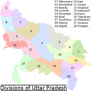
Administrative division
An administrative division, unit, entity, area or region, also referred to as a subnational entity, constituent unit, or country subdivision, is a portion of a country or other region delineated for the purpose of administration. Administrative divisions are granted a certain degree of autonomy and are usually required to manage themselves through their own local governments. Countries are divided up into these smaller units to make managing their land and the affairs of their people easier. A country may be divided into provinces, which, in turn, are divided into counties, which, in turn, may be divided in whole or in part into municipalities.
Administrative divisions are conceptually separate from dependent territories, with the former being an integral part of the state and the other being only under some lesser form of control. However, the term “administrative division” can include dependent territories as well as accepted administrative divisions (for example, in geographical databases).
For clarity and convenience the standard neutral reference for the largest administrative subdivision of a country is called the “first-level administrative division” or “first administrative level”. Next smaller is called “second-level administrative division” or “second administrative level”
18 DIVISION And 75 DISTRICT
- Agra Divisionis one of the divisions of Uttar Pradesh, India. It District Agra, Firozabad, Mainpuri and Mathura districts.
- Saharanpur division is an administrative geographical unit of Uttar Pradesh state of India. The city of Saharanpur is the administrative headquarters of the division. Southern areas of Saharanpur division are close to New Delhi, the capital of India. Hindu’s holy city of pilgrimage Haridwar is very near. Uttarakhand’s famous animal sanctuary in Shivalik hills, the Rajaji National Park, is also near.
Administrative jurisdiction
This division has three districts under its jurisdiction: Saharanpur, Shamli and Muzaffarnagar. Headquarter Saharanpur.
- Aligarh divisionis one of the administrative divisions of the Indian state of Uttar Pradesh. Aligarh division consists of:-Aligarh District, Etah District, Hathras Disrict, Kasganj District
Headquarter – Aligarh
- Allahabad divisionis an administrative unit of Indian state of Uttar Pradesh
In 2000, when Uttar Pradesh was reorganised by forming Uttaranchal out of its northern areas, Allahabad division and the district was majorly reorganised too. The Etawah, Farrukhabad and Kanpur district districts of the Allahabad division were made into a separate Kanpur division. Parts of the western areas of Allahabad district were carved out to create a new district named Kaushambi. At the sametime, Pratapgarh district, that falls in Awadh, was included in the Allahabad division.
The new Allahabad division consists of the following districts Allahabad District, Fatehpur District, Kaushambi District, Pratapgarh District
Headquarter – Allahabad
- Azamgarh divisionis an administrative unit of Indian state of Uttar Pradesh. Azamgarh division consists of:-Azamgarh District, Ballia District and Mau District
Headquarter – Azamgarh
- Bareilly divisionis an administrative geographical unit of Uttar Pradesh state of India. Bareilly is the administrative headquarters of the division. Bareilly division have 3 major cities of West UP – Bareilly, Badaun, and Shahjahanpur.
Bareilly is the medical hub of UP, one of the biggest industrial area, and 3rd fastest developing city of UP.
Budaun is politically sensantional, and historical city, and have many historical sites, and one of the oldest existing city of India, and have been capity of India in Iltutmish’s rule. It is also the 6th fastest developing city of UP.
Shahjahanpur is also one of the main cities of UP West.
Currently (2005), the division consists of districts of – Bareilly District, Badaun District, Pilibhit District, Shahjahanpur District.
Headquarter – Bareilly
- Basti Divisionis an administrative geographical unit of Uttar Pradesh state of India. Basti is the administrative headquarters of the division. Currently (2005), the division consists following districts:basti district and basti division carved out from gorakhpur district. Basti, Sidhartha Nagar, and Sant Kabir-2/”>Kabir Nagar.
Headquarter Basti.
- Chitrakoot Divisionis an administrative division of Uttar Pradesh state in northern India. Hisotrically part of Bundelkhand region, it includes the districts of: Banda, Chitrakoot, Hamirpur, and Mahoba.
Till a few years ago, this was the part of Jhansi division, but due to administrative requirements, this division was established. Chitrakoot division is one of the most backward areas of the country, which cons. full of natural raw material like moram, ballast, granite etc.
Three major rivers are part of this division: Ken,Betwa andYamuna.
Headquarter – Chitrakoot
- Devipatan divisionis an administrative geographical unit of Uttar Pradesh state of India. Currently (2005), the division consists of districts of : Gonda, Bahraich, Shravasti, and Balarampur.
Headquarter- Gonda.
- Faizabad divisionis an administrative geographical unit of Uttar Pradesh state in India. Faizabad is the administrative headquarters of the division. The division consists of districts of – Ambedkar Nagar, Amethi, Barabanki, Faizabad, Sultanpur
Headquarter – Faizabad
- Gorakhpur divisionis an administrative geographical unit of Uttar Pradesh state in northern India. Gorakhpur is the administrative headquarters of the division. Currently (2017), the division consists of four districts. Gorakhpur, Kushinagar, Deorria and Maharajganj.
Headquarter – Gorakhpur
- Jhansi Divisionis one of 17 divisions of Uttar Pradesh state in northern India. The city of Jhansi is the administrative center. The division is part of the historic Bundelkhand region, which includes a portion of southern Uttar Pradesh and extends into neighboring Madhya Pradesh state.
Jhansi Division is subdivided into three districts: Jhansi District, Jalaun District, Lalitpur District
Headquarter – Jhansi
- Kanpur divisionis an administrative geographical unit of Uttar Pradesh state of India. Kanpur is the administrative headquarters of the division. Currently (2005), the division consists of districts of: Auraiya District, Etawah, Farukhabad, Kanpur Dehat , Kanpur Nagar and Kannauj.
Headquarter – Kanpur
- Lucknow divisionis an administrative geographical unit of Uttar Pradesh state of India. Lucknow is the administrative headquarters of the division. As of 2005, the division consists of Lucknow, Hardoi, Lakhimpur Kheri, Raebareli, Sitapur, and Unnao.
Headquarter – Lucknow
- Meerut divisionis an administrative geographical unit of Uttar
Pradesh state of India. Meerut is the administrative headquarters of the division.
Currently, the division consists of the districts of Baghpat, Meerut, Ghaziabad, Hapur, Gautam Buddh Nagar and Bulandshahr.
Headquarter –Meerut
- Mirzapur divisionis a division of Uttar Pradesh state of India. Mirzapur is the administrative headquarters. Currently (2005), the division consists of districts of: Mirzapur, Sant Ravidas Nagar, Bhadohi and Sonbhadra.
Headquarter – Mirzapur
- Moradabad divisionis an administrative geographical unit of Uttar Pradesh state of India. Moradabad is the administrative headquarters of the division. Currently (2005), the division consists of districts of Moradabad, Bijnor, Rampur, Amroha and Sambhal.
Headquarter – Moradabad
- Varanasi divisionis an administrative geographical unit of Uttar Pradesh state of India. Varanasi is the administrative headquarters of the division. Currently (2005), the division consists of districts of Varanasi, Chandauli, Ghazipur, and Jaunpur and is loosely equivalent to the Benares State.
Headquarter – Varanasi
,
Uttar Pradesh is a state in northern India. It is the most populous state in India, with over 200 million people. The state is divided into 75 districts, which are further divided into tehsils and blocks. The districts of Uttar Pradesh are:
- Agra
- Aligarh
- Allahabad
- Bareilly
- Basti
- Bhadohi
- Bulandshahr
- Chandauli
- Chitrakoot
- Deoria
- Etah
- Faizabad
- Farrukhabad
- Gautam Buddha Nagar
- Ghaziabad
- Gorakhpur
- Hamirpur
- Hardoi
- Hathras
- Jhansi
- Kanpur Nagar
- Kanpur Dehat
- Kasganj
- Kaushambi
- Lakhimpur Kheri
- Lucknow
- Maharajganj
- Mathura
- Meerut
- Mirzapur
- Moradabad
- Muzaffarnagar
- Pilibhit
- Pratapgarh
- Rae Bareli
- Rampur
- Saharanpur
- Sambhal
- Shahjahanpur
- Sitapur
- Sonbhadra
- Sultanpur
- Unnao
- Varanasi
- Vrindavan
The districts of Uttar Pradesh are further divided into tehsils and blocks. Tehsils are administrative units that are smaller than districts. Blocks are the smallest administrative units in Uttar Pradesh.
The districts of Uttar Pradesh are home to a diverse range of cultures and languages. The most common languages spoken in Uttar Pradesh are Hindi, Urdu, and Punjabi. The state is also home to a number of smaller languages, such as Awadhi, Bhojpuri, and Garhwali.
The economy of Uttar Pradesh is the second largest in India. The state is a major producer of agricultural products, such as wheat, rice, and sugarcane. Uttar Pradesh is also home to a number of industrial centers, such as Kanpur, Agra, and Lucknow.
Uttar Pradesh is a beautiful state with a rich history and culture. The state is home to a number of historical monuments, such as the Taj Mahal, the Red Fort, and the Qutub Minar. Uttar Pradesh is also home to a number of religious sites, such as the Kashi Vishwanath Temple, the Allahabad Kumbh Mela, and the Vrindavan Dham.
If you are planning a trip to India, Uttar Pradesh is definitely worth a visit. The state has something to offer everyone, from historical monuments to religious sites to natural beauty.
Here are some frequently asked questions and short answers about Uttar Pradesh:
What is the capital of Uttar Pradesh?
The capital of Uttar Pradesh is Lucknow.What is the Population-of-uttar-pradesh/”>Population of Uttar Pradesh?
The population of Uttar Pradesh is 209,298,926.What is the area of Uttar Pradesh?
The area of Uttar Pradesh is 243,280 square kilometers.What is the language spoken in Uttar Pradesh?
The language spoken in Uttar Pradesh is Hindi.What is the religion of the majority of people in Uttar Pradesh?
The religion of the majority of people in Uttar Pradesh is Hinduism-2/”>Hinduism.What is the Literacy rate in Uttar Pradesh?
The literacy rate in Uttar Pradesh is 69.3%.What is the GDP of Uttar Pradesh?
The GDP of Uttar Pradesh is $1.5 trillion.What are the major industries in Uttar Pradesh?
The major industries in Uttar Pradesh are agriculture, textiles, and manufacturing.What are the major tourist attractions in Uttar Pradesh?
The major tourist attractions in Uttar Pradesh are the Taj Mahal, Agra Fort, and Fatehpur Sikri.What are some famous people from Uttar Pradesh?
Some famous people from Uttar Pradesh are Mahatma Gandhi, Jawaharlal Nehru, and Indira Gandhi.What are some challenges facing Uttar Pradesh?
Some challenges facing Uttar Pradesh are POVERTY, illiteracy, and Corruption.What are some opportunities for Uttar Pradesh?
Some opportunities for Uttar Pradesh are its large population, its natural Resources, and its strategic location.What is the future of Uttar Pradesh?
The future of Uttar Pradesh is bright. The state has a young population, a growing economy, and a strong cultural heritage. With the right policies and investments, Uttar Pradesh can become one of the most prosperous states in India.
Sure, here are some MCQs without mentioning the topic Division And District Of Uttar Pradesh:
Which of the following is the capital of Uttar Pradesh?
(A) Lucknow
(B) Agra
(C) Kanpur
(D) VaranasiWhich of the following is the largest city in Uttar Pradesh?
(A) Lucknow
(B) Agra
(C) Kanpur
(D) VaranasiWhich of the following is the most populous state in India?
(A) Uttar Pradesh
(B) Maharashtra
(C) Bihar
(D) West BengalWhich of the following is the Official Language of Uttar Pradesh?
(A) Hindi
(B) Urdu
(C) English
(D) PunjabiWhich of the following is the currency of India?
(A) Indian Rupee
(B) Pakistani Rupee
(C) Bangladeshi Taka
(D) Sri Lankan RupeeWhich of the following is the national animal of India?
(A) Tiger
(B) Lion
(C) Elephant
(D) RhinocerosWhich of the following is the national bird of India?
(A) Peacock
(B) Parrot
(C) Eagle
(D) SwanWhich of the following is the national flower of India?
(A) Lotus
(B) Rose
(C) Lily
(D) JasmineWhich of the following is the National Flag of India?
(A) A tricolor flag with saffron at the top, white in the middle and green at the bottom, with a blue wheel in the center.
(B) A green flag with a white crescent and star in the center.
(C) A saffron flag with a white tiger in the center.
(D) A red flag with a hammer and sickle in the center.Which of the following is the National Anthem of India?
(A) Jana Gana Mana
(B) Vande Mataram
(C) Saare Jahan Se Accha
(D) Ashoka Chakra
I hope these MCQs were helpful!