Araria
Araria is situated at the southern part of Purnia and Medhepura in Bihar. Borders of Araria are surrounded by Nepal in northern side, Kishanganj in western side and Supaul at south-eastern side. The district came into existence by division of Purnia district on Makar-Sankranti day of 1990. District border is adjacent to border of Nepal, so the district is important in terms of security. Jogbani is the last point of Araria and after that “Virat Nagar” district of Nepal starts. For transportation both train and road media’s are available. Araria contains two bus terminals one at ‘0’ mile and second in city. Buses for most of the districts are available and as well as for internal blocks too. Train facility is in the form of meter gauge track. This track ends one side to the Katihar, which is a big and important junction where from trains to all over India are available, other end of track is Jogbani the last point of Indian rail.
Arwal
Arwal district was earlier a part of the Jehanabad district and it came into existence in September 2001. This is the thirty-eight District of Bihar.
Arwal is situated 60 km south of Patna. The nearest airport is at Patna from where regular flights are available to all important towns and cities across the country. The nearest railway station is located at Jehanabad. By road, Arwal is efficiently linked with Jehanabad, Patna and Bhojpur.
Aurangabad
Aurangabad is a city and a Municipality in Aurangabad district in the state of Bihar, India. Aurangabad is situated on the Grand Trunk Road. The people of this region primarily speak Magahi. Due to lack of industrialization, people are still mainly dependent upon agriculture and related activities. Rice and wheat are the main crops produced here.
Aurangabad district is the part of Magadh division. The nearest rivers flowing are Sone, Punpun, Auranga, Bataane, Morhar, Aadi.
Banka
The geographical area of the district is 305621 hectare i.e. 3019.3465 Sq Km.
The district head quarter of Banka is situated in Banka town. The district has been established on 21st, February, 1991. Earlier it was a Sub-Division of a the district Bhagalpur.
The district consists 11 blocks and two towns Banka and Amarpur.
The border of the district is adjacent to the state Jharkhand. Therefore the physical character ( Natural Environment ) of the district resembles with that of Jharkhand. Chanan is the main river of the district.
The river Chanan is the largest river of the Hill streams in the district. It rises just in the north part of Deogher in Jharkhand state. It passes near Banka and joins the Ganges at Ghogha ( Bhagalpur District ). The Chanan river scheme irrigates a large area of land in Banka district.
North part of Banka has generally a plain surface except the southern area adjoining Santhalpargana ( Jharkhand). The land begins to rise at an easy ascent near or after of Banka, Barahat, so south of Banka hilly tracts commence. Thus the district of Banka has 60% of hilly area.
The river Belharni and Barua flows in the north-western area of the district. Chanan and Orhni flows from middle of the district. The river Cheer meets river Chanan in the north- eastern of Mandar Giri which rises in the east of Mandar.
The plains of Banka is formed from several streams of the these river. The plain area is very fertile.
These river are perennial. It almost dries in summer but are flood effect in rainy season.
Chanan and Barua rivers has been made useful by constructing embankments and channels. These channels irrigates the fertile lands as well as prevents floods also.
As a result of these channels water from rivers of the district is self sufficient in production of grain, fruits, vegetables etc.
Begusarai
Begusarai occupies a central position in North Bihar. In 1870 it was established as a sub-divison of the Munger district. It emerged as a district in 1972. It was named after “Begu” a man of this district who used to look after “Sarai” an old and small market.
Kaimur
Geographically, Kaimur (Bhabhua) district covers an area of about 340447 Hectares and can be divided into two parts viz. (i) Hilly area and (ii) Plain area. The hilly area comprises of Kaimur plateau. The plain area on the western side is flanked by the rivers The Karmanasha and the Durgawati. The Kudra river lies on it eastern side. The district of Buxar of Bihar State and the district of Ghazipur of U.P. State bound it on the North. On the south is the district of Garhwa of Jharkhand State and on the West is the district of Chandauli and Mirjapur of the U.P. State. On the East is district of Rohtas of Bihar State. The district has close linkage with the history of Shahabad, which was its parent district also. The old district of Shahabad had four subdivisions of which Bhabua was one. The present district of Kaimur has been formed from the whole of this Bhabua subdivision.
Bhagalpur
It is situated in the plane of Ganga basin at height Of 141 feet above sea level. It covers an area of 2569.50 sq. km. It Lies between 25o-07 – 25o30′ N Latitude and between 86o 37 ‘ – 87o 30 ‘E longitude. The district is surrounded by Munger, Khagaria, Madhepura, Purnea, Kathiar & Banka districts of Bihar and Godda & Sahebganj districts of Jharkhand.
Bhojpur
The present Bhojpur came into existence in 1992. Earlier this district was part of old Sahabad district. In the year 1972 Sahabad district was bifurcated in two parts namely Bhojpur and Rohtas. Buxar was a subdivision of old Bhojpur district. In 1992, Buxar became a separate district and rest of Bhojpur district has now three sub-divisions – Ara Sadar,Jagdishpur and Piro. Ara town is the headquarters of the district and also its principal town.
The new Bhojpur districts consists of three sub-divisions, viz., Ara Sadar; Jagdishpur and Piro comprising 14 development blocks stretching over an area of 2,37,526 hectors. The entire strip of land between the river Ganga on the north and the main line of Eastern Railway on the south is low laying deposits of silt from the Ganges almost every year and is extremely fertile. In fact, this region is considered to be the best wheat-growing area in the state of Bihar .
The district has rivers running almost three sides-North, East, and some part of Southern boundary. The Ganges forms the northern boundary of the district. The low-lying rich alluvial plains in the north-eastern and owe their fertility to the river Ganges . The rivers Chher and Banas fall into the Ganges .
The Sone is another important river in the district. The Sone enters the state of Bihar at the tri-junction of Palamu (Jharkhand), Mirzapur (U.P.) and Rohtas( Bihar ). It runs along the southern and eastern boundaries of the district of Bhojpur until it merges in the river Ganges near Maner in Patna district.
Buxar
Buxar is a small city in the state of Bihar in the Eastern part of India. Buxar District is located on the banks of river Ganges. A road bridge over Ganges connects Buxar with Ballia District in the neighboring state Uttar Pradesh. The town is connected to the state capital Patna by rail and road routes. The Buxar railway station is a major station. Many major trains pass through the station due to its strategic location. The language spoken is Bhojpuri and the script is Devanagari. Substantial proportion of trade activities are with well connected towns and cities in Uttar Pradesh such as Varanasi, Ballia and Ghazipur.
Darbhanga
Presently Darbhanga district is having the total geographical area of 2279 sq. km. and Population of 2507815 according to 1991 census. It is situated between longitude 85 degree 45’- 86 degree 25’ East and latitude 25 degree 53’ – 26 degree 27’ North and is bounded on the north by Madhubani district, on the south by Samastipur district, on the east by Saharsa district and on the west by Sitamarhi and Muzaffarpur districts.
The District of Darbhanga can be divided into four natural divisions. The eastern portion consisting of Ghanshyampur, Biraul and Kusheshwarsthan blocks contain fresh silt deposited by the Kosi River. This region was under the influence of Kosi floods till the construction of Kosi embankment in the Second Five Year Plan. It contains large tracts of sandy land covered with wild marsh.
The second division comprised of the anchals lying south of the Boorhi Gandak river and is the most fertile area in the district. It is also on higher level than the other part of the district and contains very few marshes. It is well suited to the rabbi crops.
The third natural region is the doab between the Burhi Gandak and Baghmati and consists of the low-lying areas dotted over by chaur and marshes. It gets floods every year.
The fourth division covers the Sadar sub-division of the district. This tract is watered by numerous streams and contains some up-lands.
The district has a vast alluvial plain devoid of any hills. There is a gentle slope from north to south with a depression on the centre. Numerous rivers originating in the Himalays water this district. Out of these rivers Kamla, Baghmati, Kosi and Kareh are of most importance.
The District has somewhat dry and healthy Climate. There are three well-marked seasons, the winter, the summer & the Rainy season. The cold weather begins in November and continues up to February, though March is also somewhat cool. Westerly winds begin to blow in the second half of March and temperature rises considerably. May is the hottest month when the temperature goes up to 107 degree Fahrenheit. Rain sets in towards the middle of June. With the advent of the Rainy seasons, temperature falls and humidity rises. The moist heat of the Rainy season is very oppressive up to August .The rain continues till the middle of October. Average rainfall is 1142.3 mm. around 92% of rainfall is received during monsoon months.
| East Champaran (Motihari) |
| Motihari is the headquarters of Poorvi Champaran (East Champaran) district in the state of Bihar, in India. Bakuntha Nath Temple: Bakuntha Nath Temple is located at 21 km. north of Motihari. This temple is the religious centre for the Hindus. The idols of Shiva, Parvati and Ganesh are merged in a single idol. This idol was not established by any people but it was believed that the idol was seen as “coming out from the earth. |
Motihari is reported to have the tallest and the largest Buddhist Stupa in the world, following its discovery in 1998 through excavation by the Archaeological Survey of India (ASI). Rising to a height of 104 feet, and much reduced than its reported original height, it is still one foot taller than the famous Borobodur Stupa in Java. The Stupa is located near the town of Kasaria, 120km from Patna, capital of Bihar. According to the National Informatics Centre of East Champaran (Motihari) publication, the Kesaria Stupa was 123 feet tall before the 1934 earthquake in Bihar. Originally the Kesaria Stupa was reported to have been 150 feet tall, 12 feet taller than the Borobodur stupa, which is 138 feet, according to the A.S.I. report. At present Kesaria Stupa is 104 feet and Borobodur Stupa is 103 feet. The height of ‘Sanchi Stupa ‘ a world heritage site is only 77.50 feet. Legend states that Buddha, on his last Journey, is reported to have spent a memorable night at Kesaria, where he reportedly made some historical revelations, which were later recorded in a Buddhist Jataka Story, in which it was written that in his previous births he ruled as a Chakravartin. According to the story, the Buddha also asked Licchivis to return to Vaishali after giving them “Begging Bowl, and it was believed that the Stupa in Kesaria known to the people as “Raja Ben ka deora” was built by Licchivis of Vaishali before the Buddha attained Nirvana. The Chinese pilgrim, Hieun Tshang. reportedly had visited this Stupa site in the seventh century. (Based on historical facts contributed by Sri Chandra Bhusahan Pandey of National Informatics Centre: East Champararan, Motihari.)
| Gaya |
| Gaya derives its name from the mythological demon Gayasur (which literally means Gaya the holy demon), demon (asur, a Sanskrit word) and Gaya. Over its history dating millennia, the word asur got deleted and the name Gaya remained in currency. Lord Vishnu killed Gayasur, the holy demon by using the pressure of his foot over him. This incident transformed Gayasur into the series of rocky hills that make up the landscape of the Gaya city. Gaya was so holy that he had the power to absolve the sins of those who touched him or looked at him; after his death many people have flocked to Gaya to perform shraddha sacrifices on his body to absolve the sins of their ancestors. Gods and goddesses had promised to live on Gayasur’s body after he died, and the hilltop protuberances of Gaya are surmounted by temples to various gods and goddesses. These hilltop temples at Rama Shila, Mangla Gauri, Shringa Sthan and Brahmayoni are part of the pilgrimage circuit, and grand staircases have been built up to most of them. |
Sacred places in Gaya correspond to physical features, most of which occur naturally. Ghats and temples line the banks of the sacred Falgu River. Trees such as pipal trees and Akshayavat, the undying banyan, are especially sacred. The Mangla Gauri shrine is marked by two rounded stones that symbolize the breasts of the mythological Sati, the first wife of Lord Shiva. The most popular temple today is Vishnupad Temple, a place along the Falgu River, marked by a footprint of Vishnu incised into a block of basalt, that marks the act of Lord Vishnu subduing Gayasur by placing his foot on Gayasur’s chest. The present day temple was rebuilt by Devi Ahilya Bai Holkar, the ruler of Indore, in the 18th century. Buddhist tradition regards the footstep in the Vishnupad Temple as a footstep of Buddha (who is regarded as an avatar of Vishnu by Hindus).
Gaya is significant to Hindus from the point of view of salvation to the souls of ancestors (a ritual called pindadanam). According to Ramayana, when Lord Rama came to Gaya along with Sita for pitrupaksha (or to perform pindadanam), Sita cursed the Falgu River following some disobedience on the part of the river. The mythology states that on account of this curse, Falgu River lost its water, and the river is simply a vast stretch of sand dunes.
For Buddhists, Gaya is an important pilgrimage place because it was at Brahmayoni hill that Buddha preached the Fire Sermon (Adittapariyaya Sutta) to one thousand former fire-worshipping ascetics, who all became enlightened while listening to this discourse. At that time, the hill was called Gayasisa.
Documented history of Gaya dates back to the birth of Gautam Buddha. About 15 km from Gaya town is Bodh Gaya, the place where Gautam Buddha got enlightenment. Since then the places around Gaya (Rajgir, Nalanda, Vaishali, Patliputra) had been the citadel of knowledge for the ancient world. These centers of knowledge further flourished under the rule of dynasties like the Mauryans who ruled from Patliputra (modern Patna) and covered the area beyond the boundaries of the Indian subcontinent. During this period, Gaya was a part of the Magadh region.
,
Bihar is a state in eastern India. It is the third-largest state in India by population, after Uttar Pradesh and Maharashtra. The Official Language of Bihar is Hindi, but Maithili, Bhojpuri, and Angika are also widely spoken. The capital of Bihar is Patna.
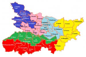
Bihar is divided into 38 districts, which are further divided into blocks and villages. The districts of Bihar are:
- Araria
- Arwal
- Bhabua
- Banka
- Begusarai
- Bhagalpur
- Bhawanipur
- Bhojpur
- Buxar
- Darbhanga
- Deoghar
- East Champaran
- Gaya
- Gopalganj
- Jamui
- Jehanabad
- Kaimur
- Khagaria
- Kishanganj
- Lakhisarai
- Madhepura
- Madhubani
- Munger
- Muzaffarpur
- Nalanda
- Nawada
- Patna
- Purnia
- Rohtas
- Saharsa
- Samastipur
- Saran
- Sheikhpura
- Sitamarhi
- Supaul
- Vaishali
- West Champaran
Bihar is also divided into five divisions: Patna Division, Tirhut Division, Magadh Division, Kosi Division, and Purnia Division.
Patna Division is the largest division in Bihar, with 10 districts. The headquarters of Patna Division is Patna.
Tirhut Division is the second-largest division in Bihar, with eight districts. The headquarters of Tirhut Division is Muzaffarpur.
Magadh Division is the third-largest division in Bihar, with six districts. The headquarters of Magadh Division is Gaya.
Kosi Division is the fourth-largest division in Bihar, with five districts. The headquarters of Kosi Division is Saharsa.
Purnia Division is the smallest division in Bihar, with four districts. The headquarters of Purnia Division is Purnia.
Bihar is a land of rich history and culture. The state is home to many ancient temples and monuments, including the Mahabodhi Temple, which is a UNESCO World Heritage Site. Bihar is also home to many universities and colleges, including the Patna University, which is the oldest university in India.
Bihar is a developing state with a population of over 100 million people. The state is facing many challenges, including POVERTY, illiteracy, and Unemployment. However, Bihar is also a state with great potential. The state has a young population, a rich natural resource base, and a growing economy.
Bihar is a state with a bright future. The state is poised to become a major economic and social force in India.
Districts of Bihar
Bihar is a state in eastern India. It is the third-largest state in India by population and the 13th-largest by area. The state is divided into 38 districts. The districts are further divided into blocks and villages.
The districts of Bihar are:
- Araria
- Arwal
- Bhabua
- Banka
- Begusarai
- Bhagalpur
- Bhojpur
- Buxar
- Darbhanga
- Gaya
- Gopalganj
- Jamui
- Jehanabad
- Kaimur
- Katihar
- Khagaria
- Kishanganj
- Lakhisarai
- Madhepura
- Madhubani
- Munger
- Muzaffarpur
- Nalanda
- Nawada
- Patna
- Purnia
- Rohtas
- Saharsa
- Samastipur
- Saran
- Sheikhpura
- Sheohar
- Sitamarhi
- Supaul
- Vaishali
- West Champaran
- East Champaran
Divisions of Bihar
Bihar is divided into nine divisions:
- Patna Division
- Bhagalpur Division
- Darbhanga Division
- Purnia Division
- Munger Division
- Gaya Division
- Araria Division
- Saharsa Division
- Kosi Division
The divisions are further divided into districts.
Frequently Asked Questions
1. What are the districts of Bihar?
The districts of Bihar are:
- Araria
- Arwal
- Bhabua
- Banka
- Begusarai
- Bhagalpur
- Bhojpur
- Buxar
- Darbhanga
- Gaya
- Gopalganj
- Jamui
- Jehanabad
- Kaimur
- Katihar
- Khagaria
- Kishanganj
- Lakhisarai
- Madhepura
- Madhubani
- Munger
- Muzaffarpur
- Nalanda
- Nawada
- Patna
- Purnia
- Rohtas
- Saharsa
- Samastipur
- Saran
- Sheikhpura
- Sheohar
- Sitamarhi
- Supaul
- Vaishali
- West Champaran
- East Champaran
2. What are the divisions of Bihar?
The divisions of Bihar are:
- Patna Division
- Bhagalpur Division
- Darbhanga Division
- Purnia Division
- Munger Division
- Gaya Division
- Araria Division
- Saharsa Division
- Kosi Division
3. What is the capital of Bihar?
The capital of Bihar is Patna.
4. What is the language spoken in Bihar?
The most widely spoken language in Bihar is Hindi. Other languages spoken in Bihar include Urdu, Maithili, Bhojpuri, Magahi, and Angika.
5. What is the religion of the majority of people in Bihar?
The majority of people in Bihar are Hindu. Other religions practiced in Bihar include Islam, Christianity, and Sikhism.
6. What is the economy of Bihar like?
The economy of Bihar is based on agriculture, Industry, and Services. The main agricultural products of Bihar are rice, wheat, maize, sugarcane, and pulses. The main industries of Bihar are textiles, sugar, jute, and engineering. The main services of Bihar are Banking, insurance, and tourism.
7. What are some of the tourist attractions in Bihar?
Some of the tourist attractions in Bihar include the Mahabodhi Temple, the Nalanda University, the Rajgir Hills, the Pawapuri Stupa, and the Vaishali Stupa.
8. What are some of the challenges facing Bihar?
Some of the challenges facing Bihar include poverty, illiteracy, and Corruption.
9. What are some of the achievements of Bihar?
Some of the achievements of Bihar include the development of the Mahabodhi Temple, the Nalanda University, and the Rajgir Hills.
10. What is the future of Bihar?
The future of Bihar is bright. The state has a young population, a rich history and culture, and a number of natural Resources. With the right policies and investments, Bihar can become a developed state in the near future.
Districts of Bihar
Bihar is a state in eastern India. It is the third-largest state in India by population and the 13th-largest by area. The state is divided into 38 districts. The capital of Bihar is Patna.
The districts of Bihar are:
- Araria
- Arwal
- Bhabua
- Banka
- Begusarai
- Bhagalpur
- Bhawanipur
- Bhojpur
- Buxar
- Champaran
- Darbhanga
- Deoghar
- East Champaran
- Gaya
- Gopalganj
- Hajipur
- Jamui
- Jehanabad
- Kaimur
- Katihar
- Khagaria
- Kishanganj
- Lakhisarai
- Madhepura
- Madhubani
- Munger
- Muzaffarpur
- Nalanda
- Nawada
- Patna
- Purnia
- Rohtas
- Saharsa
- Samastipur
- Saran
- Sheikhpura
- Sheohar
- Sitamarhi
- Supaul
- Vaishali
- West Champaran
Divisions of Bihar
Bihar is divided into nine divisions:
- Patna Division
- Saran Division
- Tirhut Division
- Bhagalpur Division
- Munger Division
- Darbhanga Division
- Purnia Division
- Saharsa Division
- Gaya Division
MCQs
Which of the following is not a district of Bihar?
(A) Araria
(B) Arwal
(C) Bhabua
(D) BuxarWhich of the following is the capital of Bihar?
(A) Patna
(B) Gaya
(C) Bhagalpur
(D) DarbhangaBihar is divided into how many divisions?
(A) 9
(B) 10
(C) 11
(D) 12Which of the following is not a division of Bihar?
(A) Patna Division
(B) Saran Division
(C) Tirhut Division
(D) Purnea DivisionWhich of the following is the largest district in Bihar by area?
(A) Araria
(B) Arwal
(C) Bhabua
(D) BuxarWhich of the following is the most populous district in Bihar?
(A) Patna
(B) Gaya
(C) Bhagalpur
(D) DarbhangaWhich of the following is the least populous district in Bihar?
(A) Araria
(B) Arwal
(C) Bhabua
(D) BuxarWhich of the following is the most literate district in Bihar?
(A) Patna
(B) Gaya
(C) Bhagalpur
(D) DarbhangaWhich of the following is the least literate district in Bihar?
(A) Araria
(B) Arwal
(C) Bhabua
(D) BuxarWhich of the following is the poorest district in Bihar?
(A) Araria
(B) Arwal
(C) Bhabua
(D) BuxarWhich of the following is the richest district in Bihar?
(A) Patna
(B) Gaya
(C) Bhagalpur
(D) DarbhangaWhich of the following districts is known for its silk industry?
(A) Bhagalpur
(B) Darbhanga
(C) Purnia
(D) SaharsaWhich of the following districts is known for its tea industry?
(A) Munger
(B) Darbhanga
(C) Purnia
(D) SaharsaWhich of the following districts is known for its rice industry?
(A) Muzaffarpur
(B) Darbhanga
(C) Purnia
(D) SaharsaWhich of the following districts is known for its sugarcane industry?
(A) Gopalganj
(B) Darbhanga
(C) Purnia
(D) Saharsa