Rajasthan: Transportation Network
Transport, an important component of the Tertiary Sector is of immense significance in a country’s Economic Development. With the advancements complexities and sophistication of the modern world, a country cannot think of attaining economic
the transport sector. Transport is an essential economic Infrastructure-2/”>INFRASTRUCTURE for the rapid development of any region. The lack of transport facilities retards the process of economic development even if a region is endowed with rich natural Resources. Transport has been recognized as an indispensable ingredient of a State’s overall development. Healthy transport system is indicator of economic Health and development of a nation. It is well known fact that road is harbinger of development in present road transport system. All development sectors get benefits of improved transport and Communication. In a vast State like Rajasthan, an integrated and efficient transportation mode is absolutely necessary for rapid economic development. Roads carry larger share of traffic.
The total road length which was just 13,553 km in 1949 increased to 2,17,707.25 km upto March, 2016. The road density in the state is 63.61 km per 100 sq. km at the end of 31March, 2016, which is much below the national Average of 166.47 km.
A number of national highways join Rajasthan to the other parts of India. The most famous highway in the state is National Highway 8. It is the oldest highway with 4-8 lanes in the country. The road network of Rajasthan is highly impressive and called as Rajasthan State Highway or “RJ SH”. In total there are 20 National Highways which extend to 5,713 km together with 85 State Highway which are extended up to 11,716 km.
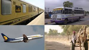
The state houses one inter-city surface transport infrastructure comprising bus Services and railways. All the major cities in the state are joined by railways, flights, and roadways.
Roadways
Rajasthan is sufficiently linked with all the major cities in India like Ahmedabad, New Delhi, and Indore through both National and State Highways.
The national highways system in Rajasthan encompasses an overall span of 5,585 km. The NH8, the most well-known highway in the state, joins major cities such as Ajmer, Jaipur, Udaipur, and Chittorgarh. The length of the NH 8 is around 688 km inside the borders of the state.
The names of the other national highways in the state are as follows: NH 11, NH 3, NH 11B, NH 11A, NH 14, NH 12, NH 65, NH 15, NH 79, NH 76, NH 89, NH 79A, NH 112, NH 90, NH 113, NH 116, and NH 114.
At present, the number of state highways in the state is 85 and the combined span of these thoroughfares is 11,716 km.
The state highways and national highways in Rajasthan represent 14.5% of the transportation system. At the same time, these highways handle 85% of the traffic movement. Bitumen roads join approximately 60% of the villages in Rajasthan.
The state is well joined with a roadways network spanning 150,876 km that runs across the state.
National Highways in Rajasthan
Given below are the names of the national highways in Rajasthan:
- NH3 – The distance between the border of Madhya Pradesh and the border of Uttar Pradesh – Majiyan is 20 miles or 32 km
- NH8 – Starting from the border of Gujarat – Bechiwara – Khairwara -Udaipur – Nathdwara – Dewair – Bhim – Beawar – Ajmer – Kishangarh – Jaipur – Manoharpur – Kotputli – Behror – Ajarka till the border of Haryana (covers a distance of 688 km or 428 miles)
- NH11 starting from Bikaner on National Highway 15 – Sri Dungarh – Ratangarh – Fatehpur – Sikar – Ringas – Jaipur – Dausa – Mahwa – Bharatpur till the border of Uttar Pradesh (covering a distance of 330 miles or 531 km)
- NH11A – Starting from Kothum on National Highway 8 connecting Lalsot, Dausa and Manoharpur (covers a distance of 90 miles or 145 km)
- NH11B – Starting from Dhaulpur on NH 3 – Bari -Barauli – Anjai – Muthra – Sir – Karauli – Gangapur and ending at its meeting point with NH 11A close to Lalsot (covers a distance of 110 miles or 180 km)
- NH12 – From Jaipur – Kothum – Tonk – Devli – Bundi – Kota – Jhalawar – Aklera – Ghatoli till the border of Madhya Pradesh (covering a distance of 250 miles or 400 km)
- NH14 – Starting from border of Gujarat – Mawal – Beawar – Abu Road – Pindwara – Sirohi – Sanderav – Pali – Chadawal (covering a distance of 190 miles or 310 km)
- NH15 – Starting from the border of Gujarat – Sanchor – Barmer – Shiv – Devikot – Jaisalmer – Pokaran – Phalodi – Kolayat – Bikaner – Lunkaransar – Suratgarh – Ganganagar and ending at the border of Punjab (covering a distance of 563 miles or 906 km)
- NH65 – Starting from Pali – Jodhpur – Soila – Nagaur – Deh – Ladnun – Salasar – Fatehpur – Churu – Rajgarh and ending at the border of Haryana (covering a distance of 252 miles or 405 km)
- NH71B – Starting near the border of Haryana close to Taoru and ending at Bhiwadi which is also close to the border of Haryana (covering a distance of 3.1 miles or 5 km)
- NH76 – Starting from the border of Madhya Pradesh – Deori – Shahbad – Kishanganj – Baran – Kota – Kheri – Pindwara – Chittaurgarh – Udaipur and ending at Gogunda (covering a distance of 300 miles or 480 km)
- NH79 – Starting from the border of Madhya Pradesh – Nimbahera – Chittaurgarh – Jharwasa – Nasirabad – Ajmer (covering a distance of 140 miles or 220 km)
- NH79A – Nasirabad (National Highway 79) – Kishangarh (National Highway 8) (covering a distance of 22 miles or 35 km)
- NH89 – Bikaner – Nokha – Nagaur – Ren – Pushkar – Ajmer (covering a distance of 190 miles or 300 km)
- NH90 Aklera – Baran (covering a distance of 62 miles or 100 km)
- NH112 – Barmer Kawas – Tilwara – Balotra -Pachpadra – Kalyanpur – Jodhpur – Kaparda – Bilara – Jaitaran – Bar – and ending at the highway’s meeting point with NH 14 close to Bar (covering a distance of 213 miles or 343 km)
- NH113 – Starting from the border of Gujarat to Banswara – Bari – Sohagpura – Pratapgarh and ending at its meeting point with National Highway 79 close to Nimbahera (covering a distance of 120 miles or 200 km)
- NH114 – Starting from near Pokaran on National Highway 15 to Dechhu – Shaitrawa – Balesar and ending at the highway’s meeting point with National Highway 65 close to Jodhpur (covering a distance of 110 miles or 180 km)
- NH116 – Starting from Sawai Madhopur and ending at the highway’s meeting point with National Highway 12 close to Tonk – r – Uniara (covering a distance of 50 miles or 80 km).
The RSRTC or Rajasthan State Road Transport Corporation, which is a state-owned organization, offers regular bus services to different parts of the state. Privately owned operators also run bus services. Rajasthan State Road Transport Corporation (RSRTC) was established on 1st October, 1964 under the Road Transport Corporation Act, 1950. Presently Rajasthan State Road Transport Corporation (RSRTC) is operating to run a total of 4,607 own and on contract Private buses. The vehicles are operated on 2,263 routes in the States, plying 15.92 lakh km and carrying 8.65 lakh passengers per day.
The total length of railway routes in the State was 5,870 km in March, 2014, which increased by 28 km and reaches 5,898 km at the end of March, 2015. The Railway length in State is 8.93 per cent of all India route length.
Railways
The North Western Railway (NWR) is one of the seventeen railway zones in India. It is headquartered at Jaipur, This zone is the key enabler of the Delhi Mumbai Industrial Corridor Project by virtue of running railways 1,500 km long Western Dedicated Freight Corridor. comprising four divisions: Jodhpur and reorganized Bikaner division of the erstwhile Northern Railway zone, and reorganized Jaipur and Ajmer divisions of the erstwhile Western Railway zone.
The state is blessed with 6 airports out which 2 are accessed by the national operators and one belongs to the Indian air force.
Airports Info
Sanganer Airport (Jaipur)
Jaipur international airport is a huge entity with all the basic amenities available to the travelers. It is located in the southern direction of the city.
Civil Airport Jodhpur (Jodhpur)
The domestic airport at Jodhpur is at a distance of 5 Km from the city.
Maharana Pratap Airport (Udaipur)
It is a domestic airport and is located about 22 km away from the city. It is one of the busiest airports because it receives flights from different sources such as Delhi, Mumbai, Jaipur along with Jodhpur.
Kota Airport (Kota)
Domestic airport of Kota was functional till 1997 when it was closed down due to the lack of flight, however private operators conduct flight on this route.
Jaisalmer Airport (Jaisalmer)
It is located 9 km away from the city; however it is only open for Indian Air force and its fighter planes.
Nal Airport (Bikaner)
The airport at Bikaner is under construction and would be soon in operation. It is situated 17 km away from the city.
Upcoming Airports
The central government has allocated funds for the construction of low budget airports at Alwar, Kota and Bhilwara. These towns are known for their artistic works and many tourists come from all over the world to buy the products. Often they have to travel by road which is costly and cumbersome. Ajmer would soon have its own airport due to its proximity to the dargah and the pushkar temple.
,
Transportation is the movement of people and goods from one place to another. It is a vital part of the economy and plays a key role in the development of Society. There are many different modes of transportation, including airports, buses, railways, roads, and waterways.
Airports are facilities that allow aircraft to take off and land. They are typically located near major cities and are used for both passenger and cargo transportation. Airports are important economic drivers, and they play a vital role in the global economy.
Buses are public transportation vehicles that carry passengers along fixed routes. They are a common mode of transportation in many cities and towns. Buses are a relatively inexpensive way to travel, and they can be a convenient way to get around if you do not have a car.
Railways are systems of tracks that allow trains to travel from one place to another. They are a major mode of transportation for both passengers and cargo. Railways are an efficient way to move large amounts of people and goods over long distances.
Roads are paved surfaces that allow vehicles to travel from one place to another. They are the most common mode of transportation in many countries. Roads are essential for the movement of people and goods, and they play a vital role in the economy.
Waterways are natural or artificial channels that allow boats and ships to travel from one place to another. They are a major mode of transportation for both passengers and cargo. Waterways are an efficient way to move large amounts of people and goods over long distances.
Each mode of transportation has its own advantages and disadvantages. Airports are fast and convenient, but they can be expensive. Buses are inexpensive, but they can be slow and crowded. Railways are efficient and comfortable, but they can be expensive to build and maintain. Roads are the most common mode of transportation, but they can be congested and dangerous. Waterways are an efficient way to move large amounts of people and goods, but they can be slow and expensive.
The best mode of transportation depends on the specific needs of the traveler. For example, if you are traveling a long distance, you may want to fly. If you are traveling on a budget, you may want to take the bus. If you are traveling in a group, you may want to rent a car. If you are traveling to a remote area, you may need to take a boat or a train.
Transportation is a complex and ever-changing Industry. New technologies are constantly being developed that are changing the way we travel. For example, self-driving cars are becoming more and more common, and they have the potential to revolutionize the transportation industry.
The future of transportation is uncertain, but it is clear that it will continue to play a vital role in the economy and society.
What are the different modes of transportation in Rajasthan?
The different modes of transportation in Rajasthan are:
- Air: There are two international airports in Rajasthan: Jaipur International Airport and Jodhpur International Airport. There are also several domestic airports in the state, including Udaipur Airport, Bikaner Airport, and Kota Airport.
- Rail: Rajasthan has a well-developed rail network, with trains connecting major cities and towns in the state. The main railway stations in Rajasthan are Jaipur Junction, Jodhpur Junction, and Udaipur City Railway Station.
- Road: Rajasthan has a good road network, with national highways and state highways connecting major cities and towns in the state. The main bus stations in Rajasthan are Jaipur Bus Stand, Jodhpur Bus Stand, and Udaipur Bus Stand.
- Water: There are no major waterways in Rajasthan, but there are several rivers and canals that are used for transportation. The main river in Rajasthan is the Chambal River.
What are the major transportation hubs in Rajasthan?
The major transportation hubs in Rajasthan are:
- Jaipur: Jaipur is the capital of Rajasthan and is a major transportation hub for the state. The city is served by Jaipur International Airport, Jaipur Junction railway station, and Jaipur Bus Stand.
- Jodhpur: Jodhpur is the second largest city in Rajasthan and is a major transportation hub for the western part of the state. The city is served by Jodhpur International Airport, Jodhpur Junction railway station, and Jodhpur Bus Stand.
- Udaipur: Udaipur is a popular tourist destination and is a major transportation hub for the southern part of the state. The city is served by Udaipur Airport, Udaipur City Railway Station, and Udaipur Bus Stand.
What are the best ways to get around Rajasthan?
The best ways to get around Rajasthan depend on your budget and your travel plans. If you are on a tight budget, the best way to get around is by bus. Buses are relatively inexpensive and connect most major cities and towns in the state. If you are looking for a more comfortable option, you can travel by train or air. Trains are a good option if you are traveling between major cities, while air travel is a good option if you are traveling long distances or if you are short on time.
What are some of the things to keep in mind when traveling in Rajasthan?
Some of the things to keep in mind when traveling in Rajasthan include:
- The weather in Rajasthan can be extreme, so it is important to pack accordingly. The summers are very hot and the winters can be very cold.
- Rajasthan is a large state, so it is important to plan your itinerary carefully. If you are short on time, you may want to focus on one or two regions of the state.
- Rajasthan is a very diverse state, so it is important to be respectful of the local culture and customs.
- Rajasthan is a safe state to travel in, but it is always a good idea to be aware of your surroundings and take precautions against petty theft.
Sure, here are some MCQs without mentioning the topic Rajasthan: Transportation Network:
Which of the following is not a mode of transportation?
(A) Air
(B) Water
(C) Land
(D) SpaceWhich of the following is the most common mode of transportation in the world?
(A) Air
(B) Water
(C) Land
(D) SpaceWhich of the following is the fastest mode of transportation?
(A) Air
(B) Water
(C) Land
(D) SpaceWhich of the following is the most expensive mode of transportation?
(A) Air
(B) Water
(C) Land
(D) SpaceWhich of the following is the most environmentally friendly mode of transportation?
(A) Air
(B) Water
(C) Land
(D) SpaceWhich of the following is the most dangerous mode of transportation?
(A) Air
(B) Water
(C) Land
(D) SpaceWhich of the following is the most popular mode of transportation in the United States?
(A) Air
(B) Water
(C) Land
(D) SpaceWhich of the following is the most popular mode of transportation in China?
(A) Air
(B) Water
(C) Land
(D) SpaceWhich of the following is the most popular mode of transportation in India?
(A) Air
(B) Water
(C) Land
(D) SpaceWhich of the following is the most popular mode of transportation in Japan?
(A) Air
(B) Water
(C) Land
(D) Space