Geographical Location of Telangana
Introduction to Telangana:
The state of Telangana emerged as 29th state in the Indian Union as per the Andhra Pradesh Reorganization Act, 2014 (No. 6 of 2014) of Parliament, which received the assent of the President of India on the 1st March, 2014 and came into existence with effect from 2nd June, 2014. The said Andhra Pradesh Reorganization Act, 2014 was received an amendment called the Andhra Pradesh Reorganization (Amendment) Act, 2014 (No. 19of 2014) on the 17th July, 2014, transferring certain mandals and villages (327) of Khammam district to residual Andhra Pradesh, enforcing this amendment with effect from 29th May, 2014.
Telangana is a state in the Southern region of India. It has an area of 1,12,077 sq.kms., after the Andhra Pradesh Reorganization (amendment) Act, 2014 (as per Act No. 6of 2014 it was 1,14,840 kms.), and is the twelfth largest state in terms of both areaand the size of the Population in the country. Most of it was part of the princely stateof Hyderabad, ruled by Nizam of Hyderabad during the British Raj, joining the Union ofIndia in 1948. In 1956, the Hyderabad state was dissolved as part of the linguisticreorganization of states, and the Telugu speaking part of Hyderabad state, known asTelangana, was merged with former Andhra State to form Andhra Pradesh. On 2nd June 2014,Telangana was separated from Andhra Pradesh as a new 29th state of India, with thecity of Hyderabad as its capital.
The state is bordered by the states of Maharashtra, Chattisgarh to theNorth, Karnataka to the west, and Andhra Pradesh to the south, east and north east.The major cities in Telangana state include Hyderabad, Warangal, Mahabubnagar,Karimnagar, Nizamabad, and Khammam. The State is strategically located in the Deccan plateau in a semi-arid region. The Climate is predominantly hot and dry.
Demography
Geographical Location of Telangana:
Telangana has an area of 1,14,800 square kilometres and it is drained by two major rivers, Krishna and Godavari. The river Godavari flows on the north, whereas Krishna flows in the south. Apart from these rivers, there are other small rivers such as Bhima, Dindi, Manjeera, Manair, Kinnerasani, Moosi etc, which also flow through Telangana. 45% of the forest area of Andhra Pradesh is in the state of Telangana. It also has a vast coal deposit and around 20% of India’s coal deposit lies in Telangana. The coal produced from this region is supplied to the states in south India.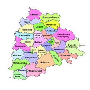
Telangana lies between 15°46’and 19°47′ N latitude and 77° 16′ and 81° 43’E longitude, and is bordered by the states of Maharashtra in the north and north-west, Karnataka in the west, Chhattisgarh in the north-east and AndhraPradesh in the south and east. The Average annual rainfall is about 906 mm, 80% of which is received from the Southwest monsoon. The State is strategically located in the Deccan Plateau in a semi-arid zone. The climate is predominately hot and dry.
Telengana Plateau of Geographical Location of Telangana:
Telengana Plateau, Telengana also spelled Telangana, plateau in western Andhra Pradesh state, southeastern India. Comprising the northeastern part of the Deccan plateau, the Telengana Plateau has an area of about 57,370 square miles (148,000 square km), a north-south length of about 480 miles (770 km), and an east-west width of about 320 miles (515 km). Mentioned in one of the Mauryan emperor Ashoka’s edicts, the region was successively ruled by the Satavahanas,
The plateau is drained by the Godavari River taking a southeasterly course; by the Krishna River, which divides the peneplain into two regions; and by the Penneru River flowing in a northerly direction. The plateau’s forests are moist deciduous, dry deciduous, and tropical thorn.
LAND UTILISATION
The total geographical area of the State is 112.07 lakh hectares, of which the area under forest cover is 27.43 lakh hectares, constituting 23.89% of the land. About 43.20% area is under cultivation (49.61 lakh hectares), 8.36% is current fallow lands (9.60 lakh hectares), 7.79% of land is put to non-agricultural uses (8.95 lakh hectares), 5.36% is barren and uncultivable (6.15 lakh hectares) and 6.24% falls under other fallows (7.17 lakh hectares). The remaining 5.16% is under culturable waste, permanent pastures and other grazing lands, and land under miscellaneous tree crops and groves are not included in the net area sown (5.93 lakh hectares).
POPULATION:
The Government of India, in exercise of powers conferred under the provisions ofthe Census Act, 1948, conducting the population census across the country once in adecade and releasing the results in different phases. Accordingly, the Government of India has conducted the population census in the year 2011 and released the final results, up to the village level, in different classifications. An attempt is made in this chapter to present the results of the population census, 2011 conducted in TelanganaState, excluding (327) revenue villages that were transferred to the state of AndhraPradesh as per the Andhra Pradesh Reorganization (Amendment) Act, 2014 (No. 19of 2014) along with certain comparisons with that of the earlier censuses. Accordingly, thegeographical area of the Telangana State is 1,12,077 Sq. Kms. And population is350.04 lakhs consisting of 176.12 Lakh males and 173.92 Lakh females, is thetwelfth largest state in terms of both area and size of population in union of India. Thesex ratio is being 988 in the state.
Growth OF POPULATION:
The people of the state are predominantly residing in rural areas with 61.12% and the restof 38.88% are residing in urban areas. The overall growth of total population duringthe decade 2001 to 2011 is 13.58%, whereas it was 18.77% in the preceding decade.The growth of the population in urban areas has been witnessing a significant increase.Urban population in the State grew by 38.12% during the decade 2001 to 2011 ascompared with 25.13% in the preceding decade. In sharp contrast, rural population in thestate grew by a modest 2.13% as per the 2011 census, which is much higher than theUnited Nations estimates of world Population Growth at 1.23%. Around 30% of totalurban population is residing in the capital city of Hyderabad alone.
SEX RATIO:
The sex ratio is defined as the number of females per 1,000 males. This ratio for thestate is 988 according to 2011 Census. One distinguishing feature is that the sex ratio in thedistricts of Nizamabad, Adilabad, Karimnagar and Khammam is over 1,000. The sex ratiohas been witnessing an improvement in the State from 967 in 1991 to 971 in 2001 andfurther to 988 in 2011. Despite a favorable sex ratio of the total population, the sex ratioof children in the age group of 0-6 years is declined from 957 in 2001 to 932 in2011. The sex ratio of the SC population at 1,008 in 2011 is much higher than theState average of 988 in all districts, except Rangareddy, Hyderabad andMahabubnagar districts. The sex ratio of ST population at 977 is marginally lower than theState average of 988, but it is higher in Adilabad, Karimnagar, Nizamabad and Khammamdistricts.
DENSITY OF POPULATION:
The density of population is defined, in general, as average number of personsresiding per square kilometer of area. The density of population in the State rangesfrom 170 to 18,172 per square kilometer. Adilabad district has the lowest density of 170 per sq. kilometer and Hyderabad district with highest density of 18,172 per sq.kilometer. The districts of Adilabad, Khammam and Mahabubnagar have lower density ofpopulation with 170, 197 and 220 per sq. kilometer respectively, as compared to theState average of 312 per sq. kilometer.
Literacy RATE:
According to the Census Of India, the literacy rate is defined as the totalpercentage of the population of an area at a particular time, aged seven years or above whocan read and write with understanding.The literacy rate of the State as per 2011 census is 66.54%. Male literacy andfemale literacy are 75.04% and 57.99%, respectively. Hyderabad district is highest with 83.25%and Mahabubnagar district at lowest with 55.04%, the same is depicted in the followinggraph
,
Telangana is a state in southern India. It was formed on 2 June 2014, after splitting from the state of Andhra Pradesh. The capital of Telangana is Hyderabad.
Telangana is a landlocked state, with a total area of 100,000 square kilometers. It is bordered by the states of Andhra Pradesh, Karnataka, Maharashtra, and Chhattisgarh.
The Climate of Telangana is tropical, with hot summers and mild winters. The average temperature in Hyderabad ranges from 20 degrees Celsius in winter to 40 degrees Celsius in summer.
The topography of Telangana is hilly, with the Deccan Plateau covering most of its area. The major rivers in Telangana are the Godavari, Krishna, and Tungabhadra.
Telangana has a large forest cover, which is home to a variety of wildlife. The state is home to a number of national parks and sanctuaries, including the Nagarjuna Sagar National Park, the Srisailam Wildlife Sanctuary, and the Papikonda National Park.
agriculture is the main occupation in Telangana, and the state is a major producer of rice, Cotton, and tobacco. The state is also home to a number of industries, including textiles, pharmaceuticals, and electronics.
Telangana is a popular tourist destination, with a number of historical and cultural sites. The state is home to a number of temples, including the Golconda Fort, the Charminar, and the Qutb Shahi Tombs.
Telangana is a beautiful and diverse state with a rich history and culture. It is a popular tourist destination, and is home to a number of industries. The state is also a major producer of rice, cotton, and tobacco.
Here are some of the historical and cultural sites in Telangana:
- Golconda Fort: The Golconda Fort is a ruined fort located in Hyderabad, Telangana. It was built in the 16th century by the Qutb Shahi dynasty. The fort is known for its intricate architecture and its massive size.
- Charminar: The Charminar is a monument located in Hyderabad, Telangana. It was built in the 16th century by the Qutb Shahi dynasty. The Charminar is a popular tourist destination and is known for its beautiful architecture.
- Qutb Shahi Tombs: The Qutb Shahi Tombs are a complex of tombs located in Hyderabad, Telangana. They were built in the 16th century by the Qutb Shahi dynasty. The tombs are a popular tourist destination and are known for their beautiful architecture.
- Warangal Fort: The Warangal Fort is a ruined fort located in Warangal, Telangana. It was built in the 13th century by the Kakatiya dynasty. The fort is known for its intricate architecture and its massive size.
- Kakatiya Rudreshwara Temple: The Kakatiya Rudreshwara Temple is a Hindu temple located in Warangal, Telangana. It was built in the 13th century by the Kakatiya dynasty. The temple is known for its beautiful architecture and its intricate carvings.
- Mahanandi Temple: The Mahanandi Temple is a Hindu temple located in Kurnool district, Telangana. It is dedicated to the god Shiva. The temple is known for its beautiful architecture and its intricate carvings.
- Belum Caves: The Belum Caves are a group of caves located in Nalgonda district, Telangana. They are the largest known caves in India. The caves are home to a variety of wildlife, including bats, snakes, and monkeys.
- Nagarjuna Sagar Dam: The Nagarjuna Sagar Dam is a dam located on the Krishna River in Nalgonda district, Telangana. It is the largest dam in India. The dam is used for Irrigation, hydroelectric power generation, and flood control.
- Srisailam Dam: The Srisailam Dam is a dam located on the Krishna River in Kurnool district, Telangana. It is the second largest dam in India. The dam is used for irrigation, hydroelectric power generation, and flood control.
- Kaleswaram Project: The Kaleswaram Project is a multi-purpose irrigation project located in Karimnagar district, Telangana. The project includes the construction of a series of Dams and canals. The project is expected to irrigate over 2 lakh hectares of land and provide drinking water to over 1 crore people.
- Yadadri Temple: The Yadadri Temple is a Hindu temple located in Yadadri Bhuvanagiri district, Telangana. It is dedicated to the god Vishnu. The temple is under construction and is expected to be completed in 2023.
What is Telangana?
Telangana is a state in India. It was formed on 2 June 2014, by splitting the northern part of the erstwhile Andhra Pradesh state. The state is bordered by Maharashtra to the north, Karnataka to the west, Chhattisgarh to the east, and Andhra Pradesh to the south. The capital of Telangana is Hyderabad.
What is the Population of Telangana?
The population of Telangana is 35,286,653 as of 2011. The sex ratio is 993 females per 1000 males. The literacy rate is 66.6%.
What is the language spoken in Telangana?
The Official Language of Telangana is Telugu. Other languages spoken in the state include Urdu, Hindi, Marathi, and Kannada.
What is the religion of Telangana?
The majority of the population of Telangana is Hindu (87.1%). Muslims (12.0%) and Christians (0.8%) are the other major religions.
What is the economy of Telangana?
The economy of Telangana is based on agriculture, Industry, and Services. The state is a major producer of rice, cotton, and tobacco. The major industries in Telangana are textiles, pharmaceuticals, and electronics. The services sector is the largest contributor to the state’s economy.
What are the tourist attractions in Telangana?
Some of the popular tourist attractions in Telangana include the Charminar, Golconda Fort, and the Qutb Shahi Tombs. The state is also home to several temples and mosques.
What are the famous people from Telangana?
Some of the famous people from Telangana include P. V. Narasimha Rao, M. C. Rajah, and K. Chandrashekar Rao.
What are the challenges faced by Telangana?
Some of the challenges faced by Telangana include POVERTY, Unemployment, and Infrastructure-2/”>INFRASTRUCTURE-development/”>Infrastructure Development. The state is also facing the problem of water scarcity.
What are the future prospects of Telangana?
Telangana is a state with a lot of potential. The state has a young population, a strong economy, and a rich culture. With the right policies and investments, Telangana can become one of the most developed states in India.
Sure. Here are some MCQs about Telangana without mentioning the topic Geographical Location of Telangana:
-
Telangana is a state in which of the following regions of India?
(A) Northern India
(B) Southern India
(C) Eastern India
(D) Western India -
Telangana is bordered by which of the following states?
(A) Andhra Pradesh
(B) Karnataka
(C) Maharashtra
(D) All of the above -
The capital of Telangana is:
(A) Hyderabad
(B) Vijayawada
(C) Amaravati
(D) None of the above -
The official language of Telangana is:
(A) Telugu
(B) Hindi
(C) English
(D) None of the above -
The population of Telangana is approximately:
(A) 35 million
(B) 40 million
(C) 45 million
(D) 50 million -
The literacy rate in Telangana is approximately:
(A) 65%
(B) 70%
(C) 75%
(D) 80% -
The main religion in Telangana is:
(A) Hinduism-2/”>Hinduism
(B) Islam
(C) Christianity
(D) Sikhism -
The main crops grown in Telangana are:
(A) Rice
(B) Cotton
(C) Tobacco
(D) All of the above -
The main industries in Telangana are:
(A) Agriculture
(B) Manufacturing
(C) IT
(D) All of the above -
The main tourist attractions in Telangana are:
(A) Golconda Fort
(B) Charminar
(C) Qutb Shahi Tombs
(D) All of the above